
Hurricane Otto (2010) facts for kids
| Category 1 hurricane (SSHWS/NWS) | |

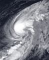
Hurricane Otto at peak intensity on October 9
|
|
| Formed | October 6, 2010 |
|---|---|
| Dissipated | October 18, 2010 |
| (Extratropical after October 10) | |
| Highest winds | 1-minute sustained: 85 mph (140 km/h) |
| Lowest pressure | 976 mbar (hPa); 28.82 inHg |
| Fatalities | None reported |
| Damage | $22.5 million (2010 USD) (Preliminary estimate) |
| Areas affected | Leeward Islands, Virgin Islands, Puerto Rico, Azores, Canary Islands |
| Part of the 2010 Atlantic hurricane season | |
Hurricane Otto was a powerful storm that brought heavy rain to the Caribbean in October 2010. It started as a special kind of storm called a subtropical cyclone near Puerto Rico on October 6.
The next day, it changed into a regular tropical storm. This made it the fifteenth storm of the 2010 hurricane season. Otto then moved northeast and became a Category 1 hurricane on October 8.
At its strongest, Otto had winds of 85 mph (140 km/h). The storm later weakened and became an extratropical cyclone (a different type of weather system) on October 10. Otto was special because it was the first Atlantic storm since 2008 to change from a subtropical storm.
Otto caused a lot of rain and flooding in the Leeward Islands, the Virgin Islands, and Puerto Rico. It also triggered many mudslides. The storm caused over $22.5 million (2010 USD) in damage to roads and buildings. Luckily, no one was reported to have died. After leaving the Caribbean, Otto moved across the open Atlantic without hitting any more land.
Contents
How Hurricane Otto Formed and Changed

In late September, a large area of stormy weather formed east of the Lesser Antilles. This weather system moved very slowly. By October 5, it had moved north over the Virgin Islands. Here, the weather conditions became better for a storm to grow.
The system started to look like a subtropical cyclone. This means it had features of both a tropical storm and a regular weather system. On October 6, weather experts officially named it a subtropical depression. It was about 265 mi (425 km) north-northwest of San Juan, Puerto Rico.
The storm then moved slowly northwest. Experts thought it might change into a full tropical storm. Soon, satellite pictures showed the storm getting stronger. Its winds reached 65 mph (105 km/h).
On October 6, the storm was upgraded to Subtropical Storm Otto. Even though it still looked subtropical, special aircraft called Hurricane Hunters found a warm center forming inside. This warm center is a key sign of a tropical storm.
As Otto moved north, its warm center grew stronger. On October 7, Otto officially became a tropical storm. This meant it had fully changed from a subtropical system.

On October 8, Otto started to speed up and move northeast. The conditions were still good for it to grow. The storm's thunderstorms became stronger and more organized around its center.
By midday, Otto's winds reached 75 mph (120 km/h). A part of the storm called an eyewall began to form. This led experts to upgrade Otto to a Category 1 hurricane. It was south of Bermuda at this time.
Otto continued to get stronger over the warm waters of the central Atlantic. It reached its strongest point with winds of 85 mph (140 km/h).
After reaching its peak, Otto moved into an area with cooler waters. The weather conditions also became less favorable. This caused the hurricane to weaken. Its cloud pattern broke apart, and its winds dropped below 70 mph (110 km/h).
By late October 9, Otto was reduced to a tropical storm. The next day, the storm started to lose its tropical features. It became an extratropical cyclone on October 10. After this, it slowly faded away near the Azores and finally disappeared west of Morocco on October 18.
Otto's Impact and Damage

Hurricane Otto and the weather system before it brought many days of heavy rain and strong winds. This affected the northern Leeward Islands, the Virgin Islands, and Puerto Rico. The heavy rain caused widespread flooding and rough seas.
Roads were damaged, and some buildings and services stopped working. Beaches also lost sand. Many people lost electricity and water during the storm. Several Caribbean nations declared a state of emergency.
Schools, businesses, and government offices in the Virgin Islands and Saint Kitts and Nevis closed. The storm caused over $22.5 million (2010 USD) in damage. Otto was known as one of the wettest storms ever in the northeastern Caribbean. It broke many rainfall records.
Impact on the Leeward Islands
| Precipitation | Storm | Location | Ref. | ||
|---|---|---|---|---|---|
| Rank | mm | in | |||
| 1 | 700.0 | 27.56 | Lenny 1999 | Meteorological Office, Phillpsburg | |
| 2 | 280.2 | 11.03 | Jose 1999 | Princess Juliana International Airport | |
| 3 | 165.1 | 6.50 | Luis 1995 | ||
| 4 | 111.7 | 4.40 | Otto 2010 | Princess Juliana International Airport | |
| 5 | 92.3 | 3.63 | Rafael 2012 | Princess Juliana International Airport | |
| 6 | 7.9 | 0.31 | Ernesto 2012 | Princess Juliana International Airport | |
| 7 | 7.0 | 0.28 | Chantal 2013 | Princess Juliana International Airport | |
| 8 | 6.6 | 0.26 | Dorian 2013 | Princess Juliana International Airport | |
In Saint Lucia, heavy rains caused big floods from October 5 to 6. In Dennery Quarter, about 500 homes were flooded or badly damaged. Some people had to leave their homes, and others were stuck inside.
Residents also had no drinking water or electricity. The area was declared a disaster zone. Money was approved to help the flood victims.

Saint Kitts and Nevis had heavy rain for at least four days. Up to 10.99 inches (279 mm) of rain fell. Many homes were flooded, and some people needed to be rescued. Strong winds caused rough seas, leading to some beach erosion. Roads and utility lines were also damaged, causing power outages.
In the U.S. Virgin Islands, Otto brought record-breaking rainfall for October. One area in Red Hook, Saint Thomas reported 21.52 in (547 mm) of rain. Roads were flooded, and shelters were opened on all three islands.
On Saint Croix, a road collapsed, cutting off a neighborhood temporarily. Floods and landslides affected low-lying areas. On Saint Thomas and Saint John, roads were closed due to flooding and rockslides. The storm caused about $2 million in damage across these islands.
The British Virgin Islands also had flash flood warnings. Heavy floods overturned cars and damaged utility lines. Many people in Tortola lost power and water. About 24.98 inches (634 mm) of rain fell. The government declared a state of emergency. Floods from Otto were considered the worst in the British Virgin Islands' history. Damage was estimated at US$10.5 million.
In Sint Maarten, widespread flooding from Otto added to damage caused by an earlier hurricane. This cost about NAƒ1.5 million ($838,000 USD). On the French side of Saint Martin, floods caused similar damage, costing about €800,000 ($1.12 million USD).
Puerto Rico's Challenges

Rain started in Puerto Rico on October 5 and lasted for up to five days in some areas. The most rain, 17.86 in (454 mm), was recorded in Rio Portugues in Ponce.
Because of the rain, the government closed over 40 roads. Another 19 streets were partly closed. In total, 295 roads were affected by flooding, with 14 suffering major damage. Road damage was estimated at US$6.5 million. The city of Ponce also lost about US$1.5 million in agriculture.
After the Arecibo River overflowed on October 7, a neighborhood in Utuado was cut off. A landslide also blocked the road, making it hard for emergency vehicles to get through.
Fourteen families in Ponce were trapped by landslides. A house by a road was badly damaged and had to be emptied. In Cayey, a district was cut off when a bridge collapsed. Flooding from burst riverbanks trapped dozens of families in their homes.
The severe flooding also polluted water supplies. About 45,000 people were left without drinking water. The government declared a state of emergency for the entire island. Authorities opened 120 shelters, and many flood victims were rescued.
Images for kids
-
Hurricane Otto at peak intensity on October 9
