
Image: Bolivia physical map

Size of this PNG preview of this SVG file: 568 × 600 pixels. Other resolution: 227 × 240 pixels.
Original image (SVG file, nominally 853 × 901 pixels, file size: 3.16 MB)
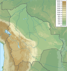
Description: Physical map of Bolivia, parameters are equal to Bolivia location map.svg
Title: Bolivia physical map
Credit: Own work
Author: Urutseg
Usage Terms: Creative Commons Zero, Public Domain Dedication
License: CC0
License Link: http://creativecommons.org/publicdomain/zero/1.0/deed.en
Attribution Required?: No
Image usage
The following 55 pages link to this image:
- Abuna River
- Acotango
- Cerro Capurata
- Cerro Columa
- Cerro Tinte
- Ch'iyar T'ikhi
- Chacaltaya
- Chachacomani
- Chaupi Orco (mountain)
- Chearoco
- Chorolque
- Cobija
- Cochabamba
- El Alto
- Huayna Potosí
- Hyloscirtus chlorosteus
- Irruputuncu
- Iñaq Uyu
- Jach'a Phasa
- Jatun Wila Qullu
- Kunturiri (Bolivia and Chile)
- Kunturiri (Los Andes)
- Lake Poopó
- Lake Tauca
- Layqa Qullu
- Licancabur
- Mount Nelly
- Mururata
- Nevado Anallajsi
- Nuevo Mundo volcano
- Ollagüe
- Pacha Qullu
- Pachat'aqa
- Parinacota (volcano)
- Paruma
- Pirwata
- Pomerape
- Puerto Rico, Pando
- Pukintika
- Pumiri
- Salar de Uyuni
- Santa Cruz, Bolivia
- Sillajhuay
- Sol de Mañana
- Sucre
- Tarija
- Tiwanaku
- Tunari (Bolivia)
- Tunupa
- Uqi Uqini
- Uru Uru Lake
- Uturuncu
- Wila Pukarani
- Wiñaymarka Lake
- Template:Location map Bolivia

All content from Kiddle encyclopedia articles (including the article images and facts) can be freely used under Attribution-ShareAlike license, unless stated otherwise.