
Image: Thurston Island - en

Size of this PNG preview of this SVG file: 800 × 454 pixels. Other resolution: 320 × 182 pixels.
Original image (SVG file, nominally 2,328 × 1,322 pixels, file size: 257 KB)
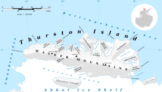
Description: Thurston Island map.
Title: Thurston Island - en
Credit: Own work Topographic map : ETOPO 1 (public domain) edited with Quantum GIS+GeoCart and vectorized with Inkscape; Lambert equal-area projection ; shaded relief; Other references used for additional data: The Geographic Names Information System (GNIS) Landsat Image Mosaic Of Antarctica (LIMA)
Author: Kaidor
Permission: You may select the license of your choice.
Usage Terms: Creative Commons Attribution-Share Alike 3.0
License: CC BY-SA 3.0
License Link: https://creativecommons.org/licenses/by-sa/3.0
Attribution Required?: Yes
Image usage
The following 49 pages link to this image:
- Barrett Island
- Bearman Glacier
- Bellisime Glacier
- Bulbur Glacier
- Cadwalader Inlet
- Cape Flying Fish
- Cape Petersen
- Craft Glacier
- Deadmond Glacier
- Dustin Island
- Foley Glacier
- Frankenfield Glacier
- Goff Glacier
- Hale Glacier
- Henry Inlet
- Hlubeck Glacier
- Isbrecht Glacier
- Kannheiser Glacier
- Koether Inlet
- Landfall Peak
- Levko Glacier
- List of glaciers on Thurston Island
- Litz Glacier
- Long Glacier
- Mahaffey Glacier
- Marck Glacier
- Mincer Glacier
- Morgan Inlet
- Mount Howell
- Mulroy Island
- Murphy Inlet
- Myers Glacier
- Payne Glacier
- Peale Inlet
- Pelter Glacier
- Rexford Glacier
- Rignot Glacier
- Robbins Glacier
- Rosanova Glacier
- Savage Glacier
- Seraph Bay
- Sessums Glacier
- Sherman Island (Antarctica)
- Sikorski Glacier
- Thurston Island
- Wagoner Inlet
- Walker Mountains
- Warr Glacier
- Zinberg Glacier

All content from Kiddle encyclopedia articles (including the article images and facts) can be freely used under Attribution-ShareAlike license, unless stated otherwise.