
King Island (Tasmania) facts for kids
 |
|

King Island
Location in Tasmania
Location of King Island in Tasmania
|
|
| Etymology | Philip Gidley King |
|---|---|
| Geography | |
| Location | Roaring Forties, Great Australian Bight and Bass Strait |
| Coordinates | 39°52′21″S 143°59′8″E / 39.87250°S 143.98556°E |
| Archipelago | New Year Group |
| Area | 1,098 km2 (424 sq mi) |
| Area rank | 3rd in Tasmania |
| Highest elevation | 162 m (531 ft) |
| Highest point | Gentle Annie |
| Administration | |
|
Australia
|
|
| State | Tasmania |
| LGA | Municipality of King Island |
| Largest settlement | Currie |
| Demographics | |
| Population | 1585 (2016 census) |
| Pop. density | 1.50 /km2 (3.88 /sq mi) |
King Island is an island in the Bass Strait, which is a sea passage between mainland Australia and Tasmania. It belongs to the Australian state of Tasmania. It is the second-largest island in Bass Strait, after Flinders Island.
King Island is part of a group of four islands called the New Year Group. In 2016, about 1,585 people lived on the island. The local government for the island is the King Island Council.
The island helps divide the waters of the Great Australian Bight and Bass Strait. It is located off the northwest tip of Tasmania. It is also about halfway to the state of Victoria on the mainland. The island has three smaller islands nearby: New Year Island and Christmas Island to the northwest, and Councillor Island to the east.
Europeans first visited King Island in the late 1700s. It was named after Philip Gidley King, who was the Governor of New South Wales. His territory included Tasmania at that time. People who hunted seals set up temporary camps on the island in the early 1800s. However, permanent towns were not built until the 1880s. The biggest town today is Currie, which is on the west coast. The island's economy now mostly relies on farming and tourism. It also has a wind farm called the Huxley Hill Wind Farm.
Contents
History of King Island
King Island was once part of a land bridge that connected Tasmania to mainland Australia. This land bridge went underwater about 12,000 years ago when sea levels rose. In 1989, a human skeleton was found in a cave on the island. It was about 14,000 years old.
However, there is no evidence that Aboriginal people lived on the island permanently. They might have passed through the area. When Europeans discovered the island, no one was living there.
European Discovery and Naming
Captain Reed was the first European known to find King Island in 1799. He was hunting seals in his ship, the Martha. Matthew Flinders made a map of "Van Diemen's Land" (Tasmania) and "Basses Strait" in 1800. This first map did not show King Island.
However, Captain Black told Flinders about the island before Flinders left Sydney in 1800. Flinders' second map, published in 1801, showed "Land of considerable extent has been seen about this situation."
Captain John Black also visited the island soon after Reed. He named it King's Island after Governor Philip Gidley King. Captain Black was sailing in a ship called the Harbinger. The dangerous Harbinger Rocks, off the island's northwest coast, are named after this ship.
Early visitors found many fur seals and Southern elephant seals on the island. These animals were hunted until they were almost gone from the area.
Claiming the Island
Governor King knew that a French explorer, Nicolas Baudin, was planning to visit the island. So, in 1800, King sent a ship called the Cumberland from Sydney. Its job was to officially claim the islands for Britain. The Cumberland arrived just before the French ships. The British quickly put up their flag in a tree.
Baudin still sailed around and mapped the island in 1802. He gave French names to some places, like "Phoques Bay" on the northwest coast. This name is still used today. Because of this event, British settlements were later started in Tasmania at the River Derwent and Port Dalrymple.
Early Settlements and Communication
Sealers continued to hunt on the island until the mid-1820s. After that, only a few old sealers and their Aboriginal wives lived there. They mostly hunted wallaby for skins. The last of these people left the island in 1854. For many years, hunters only visited the island sometimes. More often, shipwreck survivors ended up there.
In 1859, the first submarine communications cable was laid across Bass Strait. It went through King Island. This cable connected Cape Otway, Victoria, to Stanley Head in Tasmania. It then continued to George Town. However, it stopped working within a few weeks and completely failed by 1861. A later telephone and telegraph cable also went through King Island from 1936 to 1963.
In the 1880s, land on King Island was opened for farming and grazing. A town grew at Currie. The post office there opened on June 1, 1892. Currie is now the only town with a post office on the island. Other areas on King Island include Bungaree, Loorana, Lymwood, Nugara, Pegarah, Reekara, Sea Elephant, Surprise Bay, Wickham, and Yarra Creek. All of them share the postcode 7256.
Shipwrecks Around King Island

King Island is located in a dangerous spot at the western entrance to Bass Strait. Because of this, more than 60 known shipwrecks have happened near the island. Over 2,000 lives have been lost. Many people who live on King Island today are descendants of shipwreck survivors.
Some of the most famous shipwrecks include:
- 1801: A large, unknown three-masted ship, probably a whaler. No known survivors.
- 1835: The Neva, a convict ship. 225 lives were lost.
- 1845: The Cataraqui, a large sailing ship. 400 lives were lost, making it Australia's deadliest maritime disaster.
- 1854: The Brahmin, a sailing ship. 17 lives were lost.
- 1855: The Whistler, an American clipper ship. Two lives were lost.
- 1866: The Netherby, a large sailing ship. No lives were lost.
- 1874: The British Admiral, an iron clipper ship. 79 lives were lost.
- 1920: The Southern Cross, a timber ship. At least 9 lives were lost.
King Island Today

King Island has several towns and interesting places to visit.
Currie
Currie is the largest town on King Island. It is also the main administrative center. You can find it on the west coast of the island.
Grassy
The town of Grassy is on the east coast of the island. It is about 32 kilometres (20 mi) southeast of Currie. Grassy used to be a busy mining town. People mined a mineral called scheelite there until 1990. After the mine closed, the area was cleaned up, and the mine pit filled with water.
Recently, more people have moved to Grassy. It has local families, people looking for a change, and a campus of Ballarat Clarendon College. You can find a service station, a supermarket, and several shops and restaurants there. Grassy is also known for its little penguin colony near the port. You might also spot platypus at the Upper Grassy Dam. Ferries bring supplies to the island with weekly services between Victoria, Northern Tasmania, and Grassy Harbour.
A new $12.3 million wave power project is planned for Grassy. This project, called Uniwave 200, will sit partly underwater. It will use the movement of waves to create electricity.
Naracoopa
The village of Naracoopa is on the east coast. It is about 20 kilometres (12 mi) from Currie. Naracoopa is famous for its beach, fishing jetty, and places to stay for holidays. There is a sheltered BBQ area and public toilets near the beach.
Naracoopa was once the main port for fuel and a place where minerals were dug up. Between 1968 and 1977, minerals like rutile, zircon, and ilmenite were taken from the sand here. Naracoopa's attractions include its 100-year-old jetty, a blowhole, and calmer weather.
Economy and Culture
King Island is well-known for its delicious products. These include cheese, lobsters, bottled rain water, kelp, and beef. The island's beef industry faced challenges when its only meat processing plant closed in 2012.
The island is a safe place for yachts passing by. It is also home to the Huxley Hill Wind Farm, which creates electricity from wind.
King Island has its own football competition. It has three teams: Currie, Grassy, and North. The island also hosts the Stonehaven Cup boat races, the Imperial 20-foot race, and a pheasant hunting season on the Queen's Birthday Weekend.
There was a plan to build Australia's largest windfarm on the island. This idea caused some disagreement among the community. In the end, it was decided that the project would be too expensive, and the plan was stopped in late 2014.
The Dolphin mine, located on the southeast side of the island, holds one of Australia's largest reserves of tungsten. Tungsten is a strong metal used in many industries.
Environment
Birds of King Island

The King Island emu was a type of emu that lived only on this island. Many bones of this bird have been found. However, the only existing skin was collected by Nicolas Baudin in 1802. Soon after, this emu became extinct, probably because seal hunters used them for food.
About 193 square kilometers of the island's coastline is an Important Bird Area (IBA). This area includes the land from the low water mark to one kilometer inland. It also includes a larger area called Lavinia State Reserve in the northeast. This area is important because it supports a small number of critically endangered orange-bellied parrots. These parrots use King Island as a stopover during their migration. They fly between their breeding grounds in southwestern Tasmania and their winter homes in mainland southeastern Australia. Recently, Lake Flannigan was also identified as important for these birds.
The IBA also includes the nearby Christmas, New Year, and Councillor Islands. These islands are home to many breeding seabirds and waders (birds that feed in shallow water). The IBA has many hooded plovers, flame robins, and fairy terns. It also has over 1% of the world's population of short-tailed shearwaters, pied and sooty oystercatchers, black-faced cormorants, and pacific gulls. Additionally, it has ten bird species that are only found in Tasmania, including seven subspecies that are unique to King Island.
Climate of King Island
King Island has a climate that is a mix of Mediterranean and oceanic. This means it has mild summers and wet winters.
| Climate data for King Island | |||||||||||||
|---|---|---|---|---|---|---|---|---|---|---|---|---|---|
| Month | Jan | Feb | Mar | Apr | May | Jun | Jul | Aug | Sep | Oct | Nov | Dec | Year |
| Record high °C (°F) | 37.8 (100.0) |
37.6 (99.7) |
35.0 (95.0) |
30.0 (86.0) |
23.1 (73.6) |
18.6 (65.5) |
18.0 (64.4) |
19.6 (67.3) |
26.5 (79.7) |
29.5 (85.1) |
33.0 (91.4) |
36.0 (96.8) |
37.8 (100.0) |
| Mean daily maximum °C (°F) | 20.3 (68.5) |
20.6 (69.1) |
19.6 (67.3) |
17.2 (63.0) |
15.1 (59.2) |
13.5 (56.3) |
12.9 (55.2) |
13.2 (55.8) |
14.3 (57.7) |
15.6 (60.1) |
17.0 (62.6) |
18.7 (65.7) |
16.5 (61.7) |
| Mean daily minimum °C (°F) | 12.5 (54.5) |
13.1 (55.6) |
12.6 (54.7) |
11.2 (52.2) |
9.8 (49.6) |
8.5 (47.3) |
7.8 (46.0) |
7.8 (46.0) |
8.3 (46.9) |
9.0 (48.2) |
9.9 (49.8) |
11.3 (52.3) |
10.2 (50.4) |
| Record low °C (°F) | 6.4 (43.5) |
7.0 (44.6) |
6.1 (43.0) |
2.0 (35.6) |
1.1 (34.0) |
1.0 (33.8) |
−0.5 (31.1) |
−0.5 (31.1) |
1.7 (35.1) |
0.0 (32.0) |
0.6 (33.1) |
4.6 (40.3) |
−0.5 (31.1) |
| Average precipitation mm (inches) | 35.6 (1.40) |
38.8 (1.53) |
48.0 (1.89) |
67.8 (2.67) |
98.0 (3.86) |
102.4 (4.03) |
124.1 (4.89) |
114.7 (4.52) |
84.2 (3.31) |
74.8 (2.94) |
59.8 (2.35) |
52.3 (2.06) |
900.2 (35.44) |
| Average precipitation days | 6.4 | 6.2 | 8.3 | 11.6 | 15.3 | 16.5 | 19.3 | 18.8 | 15.4 | 13.1 | 10.3 | 8.7 | 149.9 |
| Source: Bureau of Meteorology." | |||||||||||||
Images for kids
-
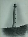
Built in 1861, the Cape Wickham Lighthouse is Australia's tallest lighthouse. It was officially opened in 2011.
-
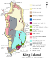
The surface geology of King Island.


See also
 In Spanish: Isla King (Australia) para niños
