Lincoln County, Nevada facts for kids
Quick facts for kids
Lincoln County
|
|||
|---|---|---|---|
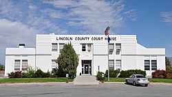
Lincoln County Courthouse in Pioche
|
|||
|
|||
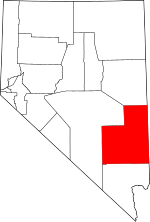
Location within the U.S. state of Nevada
|
|||
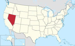 Nevada's location within the U.S. |
|||
| Country | |||
| State | |||
| Founded | 1866 | ||
| Named for | Abraham Lincoln | ||
| Seat | Pioche | ||
| Largest city | Caliente | ||
| Area | |||
| • Total | 10,637 sq mi (27,550 km2) | ||
| • Land | 10,633 sq mi (27,540 km2) | ||
| • Water | 3.8 sq mi (10 km2) 0.04% | ||
| Population
(2020)
|
|||
| • Total | 4,499 | ||
| • Estimate
(2023)
|
4,452 |
||
| • Density | 0.42296/sq mi (0.163305/km2) | ||
| Time zone | UTC−8 (Pacific) | ||
| • Summer (DST) | UTC−7 (PDT) | ||
| Congressional district | 4th | ||
Lincoln County is a large area of land called a county in the state of Nevada, United States. In 2020, about 4,499 people lived here. This makes it the fourth-least populated county in Nevada. The main town, or county seat, where the county government is located, is Pioche. Like many parts of Nevada, Lincoln County is very dry and doesn't have many people. It's famous for being home to Area 51, a secret U.S. Air Force base.
Contents
History of Lincoln County
Lincoln County was created in 1866. This happened after the U.S. Congress made Nevada bigger by moving its borders. They took land from the Utah and Arizona areas. The county was named after Abraham Lincoln, who was the 16th President of the United States.
The first main town of Lincoln County was Crystal Springs in 1866. Then it moved to Hiko in 1867, and finally to Pioche in 1871.
Long ago, a small ranch village and train stop called Las Vegas was part of Lincoln County. But in 1909, this area was separated to form Clark County. This is where the big city of Las Vegas is today.
Area 51, a well-known government Air Force base, is located in Lincoln County. The local county sheriff helps with security around its borders.
Geography and Landscape
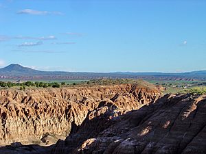
Lincoln County is a very large area. It covers about 10,637 square miles. Most of this is land, with only a small amount of water. Even though it's the third-largest county in Nevada, it's actually the seventh-largest county in the entire United States (not counting areas in Alaska).
The highest point in Lincoln County is on the south side of Mount Rummel. This mountain's very top is just outside the county line. The highest mountain completely inside Lincoln County is Shingle Peak. The most noticeable mountain, meaning it stands out the most from its surroundings, is Mormon Peak.
Main Roads and Highways
Neighboring Counties
- White Pine County - to the north
- Millard County, Utah - to the northeast
- Beaver County, Utah - to the east
- Iron County, Utah - to the east
- Washington County, Utah - to the east
- Mohave County, Arizona - to the southeast
- Clark County, Nevada - to the south
- Nye County, Nevada - to the west
Protected Natural Areas
Lincoln County is home to several important natural areas that are protected. These include:
- Desert National Wildlife Refuge (part of it)
- Humboldt National Forest (part of it)
- Pahranagat National Wildlife Refuge
The county also has 16 official wilderness areas. These are special places where the land is kept wild and untouched. They are managed by the Bureau of Land Management. Some of these wilderness areas also stretch into neighboring counties.
- Big Rocks Wilderness
- Clover Mountains Wilderness
- Delamar Mountains Wilderness
- Far South Egans Wilderness
- Fortification Range Wilderness
- Meadow Valley Range Wilderness
- Mormon Mountains Wilderness
- Mount Grafton Wilderness
- Mount Irish Wilderness
- Parsnip Peak Wilderness
- South Egan Range Wilderness
- South Pahroc Range Wilderness
- Tunnel Spring Wilderness
- Weepah Spring Wilderness
- White Rock Range Wilderness
- Worthington Mountains Wilderness
People and Population
| Historical population | |||
|---|---|---|---|
| Census | Pop. | %± | |
| 1870 | 2,985 | — | |
| 1880 | 2,637 | −11.7% | |
| 1890 | 2,466 | −6.5% | |
| 1900 | 3,284 | 33.2% | |
| 1910 | 3,489 | 6.2% | |
| 1920 | 2,287 | −34.5% | |
| 1930 | 3,601 | 57.5% | |
| 1940 | 4,130 | 14.7% | |
| 1950 | 3,837 | −7.1% | |
| 1960 | 2,431 | −36.6% | |
| 1970 | 2,557 | 5.2% | |
| 1980 | 3,732 | 46.0% | |
| 1990 | 3,775 | 1.2% | |
| 2000 | 4,165 | 10.3% | |
| 2010 | 5,345 | 28.3% | |
| 2020 | 4,499 | −15.8% | |
| 2023 (est.) | 4,452 | −16.7% | |
| U.S. Decennial Census 1790-1960 1900-1990 1990-2000 2010-2020 |
|||
In 2010, there were 5,345 people living in Lincoln County. These people lived in 1,988 homes, and 1,282 of these were families. The county has a very low population density, meaning there are not many people living in each square mile.
Most of the people in the county were white (91.1%). Other groups included Black or African American (2.3%), American Indian (1.1%), and Asian (0.7%). About 6.2% of the population was of Hispanic or Latino background. Many people had ancestors from England (39.8%), Germany (19.5%), or Ireland (12.4%).
About 28.9% of homes had children under 18 living there. More than half of the homes (53.0%) were married couples. The average age of people in the county was about 39.9 years old.
The average income for a family in the county was around $56,167 per year. About 10.6% of all people in the county lived below the poverty line. This included 12.5% of children under 18.
Education in Lincoln County
Public schools in Lincoln County are managed by the Lincoln County School District. Here are some of the schools in the area:
- Pioche Elementary School
- Caliente Elementary School
- Pahranagat Valley Elementary School
- Panaca Elementary School
- Meadow Valley Middle School
- Pahranagat Valley Middle School
- Lincoln County High School
- C. O. Bastian High School
- Pahranagat Valley High School
Towns and Communities
Cities
Census-Designated Places (CDPs)
These are areas that are like towns but are not officially incorporated as cities.
- Alamo
- Beaverdam
- Bennett Springs
- Dry Valley
- Hiko
- Mount Wilson
- Panaca
- Pioche (This is the county seat)
- Rachel
- Ursine
Unincorporated Communities
These are small settlements that are not officially part of a city or CDP.
Ghost Towns
These are towns that used to be active but are now mostly abandoned.
Future Developments
- Coyote Springs — This is a planned community that could one day have a very large population.
Notable People from Lincoln County
- Helen J. Stewart – At one point, she owned the most land in the county.
- Michael Heizer – A famous land artist who lives near his large artwork called City.
See also
 In Spanish: Condado de Lincoln (Nevada) para niños


