List of drainage basins of Australia facts for kids
A drainage basin is like a giant funnel on land. When rain or melting snow falls, all the water in that area flows downhill into a single body of water. This could be a river, a lake, or even the ocean! The basin includes all the streams and rivers that carry the water, plus the land around them. Imaginary lines called drainage divides separate one basin from another.
In Australia, these important water areas are organized into different levels. The biggest ones are called Level 1 drainage divisions. Smaller river areas within them are Level 2. This helps experts manage water resources. This article focuses on surface water, which is water you can see, not underground water like in the Great Artesian Basin.
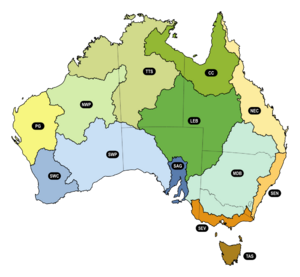
Australia has 13 main drainage divisions. These were defined by a water survey in 2012. Water from these divisions usually flows into the Pacific Ocean, the Indian Ocean, the Southern Ocean, or Lake Eyre.
Australia's Major Water Basins
Australia has 13 major drainage divisions. Each one collects water from a large area and sends it towards a specific ocean or lake. Here's a look at some of them:
| Name | Area (square km) | Where it Drains | Fun Facts |
|---|---|---|---|
| North East Coast (Queensland) | 451,000 | Coral Sea (Pacific Ocean) | This area gets a lot of rain. |
| South East Coast (New South Wales) | 129,500 | Tasman Sea (Pacific Ocean) | Includes important rivers like the Hawkesbury River. |
| South East Coast (Victoria) | 134,600 | Southern Ocean, Bass Strait | Home to the Yarra River in Melbourne. |
| Tasmania | 68,000 | Southern Ocean, Bass Strait, Tasman Sea (Pacific Ocean) | Much of its water is used to make hydroelectricity. |
| Murray-Darling Basin | 1,061,000 | Southern Ocean | Australia's largest river system, very important for farming. |
| South Australian Gulf | 117,700 | Great Australian Bight (Southern Ocean) | Includes rivers near Adelaide. |
| South Western Plateau | 1,093,000 | Great Australian Bight (Southern Ocean) | This is the driest part of Australia. |
| South West Coast | 326,000 | Indian Ocean, Great Australian Bight (Southern Ocean) | Located in Western Australia. |
| Pilbara-Gascoyne | 478,000 | Indian Ocean | Known for its dry, rugged landscape. |
| North Western Plateau | 716,000 | Indian Ocean | Another very dry region with no major water storage. |
| Tanami-Timor Sea Coast | 1,162,000 | Timor Sea (Indian Ocean) | This area gets a lot of rain during the wet season. |
| Lake Eyre Basin | 1,281,000 | Lake Eyre | This basin is unique because its water flows inland to a lake, not the ocean. |
| Carpentaria Coast | 647,000 | Gulf of Carpentaria, Arafura Sea | Located in northern Australia. |
Smaller Water Areas
Within these large divisions, there are many smaller river and island areas. These are called Level 2 drainage basins. They help manage water for local communities and ecosystems.
North East Coast Examples
Here are just a few examples of smaller water areas within the North East Coast division:
- Jacky Jacky Creek
- Barron River
- Mulgrave-Russel Rivers
- Johnstone River
- Tully-Murray Rivers
- Burdekin River
- Fitzroy River (QLD)
- Brisbane River
- Daintree River
See also
- List of reservoirs and dams in Australia
- List of rivers of Australia
- Geography of Australia
- Climate change in Australia
- Drought in Australia
- Great Artesian Basin


