
Luxembourg (Belgium) facts for kids
Quick facts for kids Luxembourg |
|||
| Province of Belgium | |||
 Arlon centre with bell tower of St. Martin's Church
|
|||
|
|||
| Country | |||
|---|---|---|---|
| Region | |||
| Capital | Arlon | ||
| - coordinates | 49°41′N 5°49′E / 49.683°N 5.817°E | ||
| Highest point | Baraque de Fraiture | ||
| - location | Vielsalm, Bastogne, Luxembourg | ||
| - elevation | 652 m (2,139 ft) | ||
| - coordinates | 50°15′04″N 5°43′55″E / 50.25111°N 5.73194°E | ||
| Area | 4,443 km² (1,715 sq mi) | ||
| Population | 281,972 (1 January 2017) | ||
| Density | 63 /km² (163 /sq mi) | ||
| Subdivisions | 5 Arrondissements 44 Municipalities |
||
| Governor | Olivier Schmitz | ||
| Timezone | CET (UTC+1) | ||
| - summer (DST) | CEST (UTC+2) | ||
| Postal codes | 6600–6999 | ||
| ISO 3166-2 | BE-WLX | ||


Luxembourg is the southernmost province in Belgium and part of the Wallonia region. It is also the largest province in Belgium, covering about 4,443 square kilometers.
Its capital city is Arlon, located in the southeast. This province is sometimes called "Belgian Luxembourg" to avoid confusion with the nearby independent country, the Grand Duchy of Luxembourg.
Contents
Geography of Luxembourg Province
This province shares borders with the Grand Duchy of Luxembourg to the east, France to the south, and other Belgian provinces like Namur and Liège to the west and north.
Even though it's the largest province in Belgium by area, it has the smallest population. This means it's not very crowded! It's also much bigger and less populated than the neighboring Grand Duchy of Luxembourg.
Natural Areas
The province has two main natural areas:
- The Belgian Lorraine in the southern part.
- The Ardennes forest in the center and north.
The highest point in the province is the Baraque de Fraiture, which is 652 meters (2,139 feet) tall. It's located in the town of Vielsalm.
Rivers in the Province
Several important rivers flow through Luxembourg province:
- The Semois river flows from east to west in the south. It eventually joins the Meuse river.
- The Sauer (also called Sûre) river is a tributary of the Moselle river.
- The Lesse river also flows into the Meuse river.
- The Ourthe river is another tributary of the Meuse river.
History of Luxembourg Province
The province of Luxembourg became separate from the Grand Duchy of Luxembourg in 1839. This happened after the Belgian Revolution, when Belgium became an independent country. The province then officially became part of Belgium.
Most people in Luxembourg province speak French. However, there is a small group of people who speak Luxembourgish in an area called Arelerland, which is close to the border with the Grand Duchy of Luxembourg.
How the Province is Organized
The province of Luxembourg is divided into 5 main areas called arrondissements. These arrondissements are then split into a total of 44 smaller towns and villages, known as municipalities.


Main Areas and Towns
Here are the five arrondissements and some of the towns within them:
| Arlon | Bastogne | Marche-en-Famenne |
|---|---|---|

|

|

|
| Neufchâteau | Virton | |

|

|
Population Changes
The population of Luxembourg province has been steadily growing. Here's how the population in each main area (arrondissement) has changed over a few years:
| Arrondissement | 2007 | 2008 | 2009 | 2010 | 2011 | 2012 |
|---|---|---|---|---|---|---|
| Arlon | 55,593 | 56,392 | 57,376 | 57,850 | 58,463 | 59,204 |
| Bastogne | 43,444 | 44,012 | 44,555 | 45,061 | 45,453 | 45,705 |
| Marche-en-Famenne | 53,123 | 53,593 | 54,003 | 54,214 | 54,797 | 55,228 |
| Neufchâteau | 58,151 | 58,726 | 59,385 | 59,861 | 60,368 | 60,791 |
| Virton | 50,867 | 51,361 | 51,631 | 52,037 | 52,271 | 52,710 |
| Province of Luxembourg | 261,178 | 264,084 | 266,950 | 269,023 | 271,352 | 273,638 |
Images for kids
-
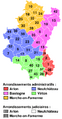
Province of Luxembourg composite map showing arrondissements (districts) and numbered municipalities.
-fr.png)
See also
 In Spanish: Provincia de Luxemburgo para niños
