Mayes County, Oklahoma facts for kids
Quick facts for kids
Mayes County
|
|
|---|---|

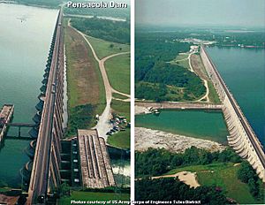
Pensacola Dam on the Neosho River in-between Disney and Langley on Oklahoma State Highway 28, creating Grand Lake o' the Cherokees.
|
|

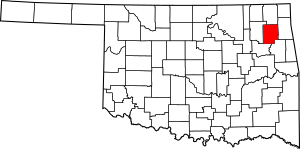
Location within the U.S. state of Oklahoma
|
|
 Oklahoma's location within the U.S. |
|
| Country | |
| State | |
| Founded | November 16, 1907 |
| Named for | Samuel Houston Mayes |
| Seat | Pryor Creek |
| Largest city | Pryor Creek |
| Area | |
| • Total | 684 sq mi (1,770 km2) |
| • Land | 655 sq mi (1,700 km2) |
| • Water | 28 sq mi (70 km2) 4.1%% |
| Population
(2020)
|
|
| • Total | 39,046 |
| • Density | 57.08/sq mi (22.041/km2) |
| Time zone | UTC−6 (Central) |
| • Summer (DST) | UTC−5 (CDT) |
| Congressional district | 2nd |
Mayes County is a county in the state of Oklahoma. In 2020, about 39,046 people lived there. The main town and county seat is Pryor Creek.
The county is named after Samuel Houston Mayes. He was a very important leader of the Cherokee Nation from 1895 to 1899. Mayes County was first created in August 1905 at a meeting called the Sequoyah Convention.
Contents
History of Mayes County
The land that is now Mayes County has a very long history. Experts have found many signs of people living here a long, long time ago. Some evidence shows humans were here even before 6,000 BC! There are also many sites from later periods, like the Archaic, Woodland, and Plains Village times.
Early Explorers and Settlers
In the early 1700s, French explorers called voyageurs traveled through this area. They gave French names to many rivers and places. Jean Pierre Chouteau set up a trading post in what is now Salina. He traded mostly with the Osage tribe who lived nearby. Later, in 1820, a place called Union Mission was started near the town of Chouteau, Oklahoma. In 1835, the first printing press in this part of the United States was set up there by Rev. Samuel Worcestor.
Cherokee Nation and Civil War
In 1828, some members of the Western Cherokee Nation moved to the area from their old lands in Arkansas. Later, in the 1830s, the Eastern Cherokee were forced to move here too. They came from their homes in Tennessee, Georgia, and North Carolina. By 1841, the Mayes County area became part of the Saline District of the Cherokee Nation.
During the American Civil War, there were some battles in this part of Oklahoma. In July 1862, Union Army soldiers surprised a Confederate unit near Locust Grove, Oklahoma. The Union side won and captured many soldiers. In July 1863, Confederate General Stand Watie tried to capture a Union supply train. But Union forces stopped him. This was called the First Battle of Cabin Creek. In September 1864, General Watie and General Richard Gano did capture a Union supply train in the same spot. This was known as the Second Battle of Cabin Creek.
Growth and Transportation
After the Civil War, new ways to travel helped the area's economy grow. The East Shawnee Trail, an early path for moving cattle, followed the Grand River. The Texas Road came through later. From 1871 to 1872, the Missouri-Kansas-Texas Railroad built its tracks through the county. Another railroad, the Missouri, Oklahoma and Gulf Railway, built a line in 1913.
Geography of Mayes County
Mayes County covers about 684 square miles. About 655 square miles are land, and 28 square miles (4.1%) are water.
The Grand River flows right through the middle of the county. The eastern part of the county is on the Ozark Plateau. This area has flat parts with deep valleys where streams flow. The western part is in the Prairie Plains.
Lakes and Waterways
Mayes County has several large man-made lakes. These include:
- Lake Fort Gibson
- Lake Spavinaw
- Grand Lake o' the Cherokees
- Lake Hudson
- Salina Pumped Storage Project
Lake Spavinaw provides water for the city of Tulsa. The other three big lakes were built by the government. They help control floods and create electricity. The Grand River Dam Authority (GRDA) manages these lakes and also runs a power plant that uses coal.
Main Roads
Neighboring Counties
- Craig County (north)
- Delaware County (east)
- Cherokee County (southeast)
- Wagoner County (south)
- Rogers County (west)
Population of Mayes County
| Historical population | |||
|---|---|---|---|
| Census | Pop. | %± | |
| 1910 | 13,596 | — | |
| 1920 | 16,829 | 23.8% | |
| 1930 | 17,883 | 6.3% | |
| 1940 | 21,668 | 21.2% | |
| 1950 | 19,743 | −8.9% | |
| 1960 | 20,073 | 1.7% | |
| 1970 | 23,302 | 16.1% | |
| 1980 | 32,261 | 38.4% | |
| 1990 | 33,366 | 3.4% | |
| 2000 | 38,369 | 15.0% | |
| 2010 | 41,259 | 7.5% | |
| 2020 | 39,046 | −5.4% | |
| U.S. Decennial Census 1790-1960 1900-1990 1990-2000 2010 |
|||
In 2020, Mayes County had a population of 39,046 people.
In 2010, the population was 41,259. Most people were white (68.0%). About 21.4% were Native American. Other groups included Asian, Black, and people of two or more races. About 2.7% of the population was Hispanic or Latino.
Most people in the county speak English. Some also speak Cherokee, Spanish, or German.
Economy of Mayes County
For a long time, farming has been the main way people make a living in Mayes County. Important crops grown here include corn, soybeans, sorghum, and hay. Raising cattle and dairy farming also happen, especially in the hillier parts of the Ozark Plateau.
Industry and Jobs
In 1941, a large factory called the Oklahoma Ordnance Works was built near Pryor. It made military supplies. After World War II, the factory closed for many years. In 1960, it became the MidAmerica Industrial Park. This park now has factories that make things like paper, cement, and fertilizer.
The Grand River Dam Authority (GRDA) is also a big employer. They run several power plants that use water to make electricity. They also have two power plants that burn coal to create electricity.
There is also a Google data center in the county, which is a big computer storage facility.
Communities in Mayes County
City
- Pryor Creek (This is the county seat, where the main government offices are.)
Towns
- Adair
- Chouteau
- Disney
- Grand Lake Towne
- Hoot Owl (This is a ghost town, meaning it's mostly abandoned.)
- Ketchum
- Langley
- Locust Grove
- Pensacola
- Salina
- Spavinaw
- Sportsmen Acres
- Strang
Census-Designated Places (CDPs)
These are areas that are like towns but are not officially incorporated as cities or towns.
- Ballou
- Cedar Crest
- Iron Post
- Kenwood
- Little Rock
- Mazie
- Murphy
- Pin Oak Acres
- Pump Back
- Rose
- Sams Corner
- Snake Creek
- Sportmans Shores
- Sportsmen Acres Community
- Wickliffe
Other Unincorporated Community
Education in Mayes County
Here are the school districts in Mayes County:
- Adair Public Schools
- Chelsea Public Schools
- Chouteau-Mazie Public Schools
- Inola Public Schools
- Jay Public Schools
- Ketchum Public Schools
- Locust Grove Public Schools
- Pryor Public Schools
- Salina Public Schools
- Vinita Public Schools
There are also two elementary school districts: Osage Public School and Wickliffe Public School.
The Big Cabin School District used to cover parts of the county until 1992. It then joined with the Vinita school district.
Historic Places in Mayes County
Several places in Mayes County are listed on the National Register of Historic Places. This means they are important historical sites.
- Cabin Creek Battlefield, Pensacola
- Farmers and Merchants Bank, Chouteau
- Lewis Ross/Cherokee Orphan Asylum Springhouse, Salina
- Pensacola Dam, Langley
- Territorial Commercial District, Chouteau
- Union Mission Site, Mazie
See also
 In Spanish: Condado de Mayes para niños

