
Mount Washington facts for kids
Quick facts for kids Mount Washington |
|
|---|---|

Mount Washington from Intervale
|
|
| Highest point | |
| Elevation | 6,288.3 ft (1,916.7 m) NAVD 88 |
| Prominence | 6,148 ft (1,874 m) |
| Listing |
|
| Geography | |

Location in New Hampshire

Location in the United States
|
|
| Location | |
| Parent range | Presidential Range |
| Topo map | USGS Mount Washington |
| Climbing | |
| First ascent | 1642 (first recorded) |
| Easiest route | Hike, ride cog railway, or drive via Mount Washington Auto Road. |
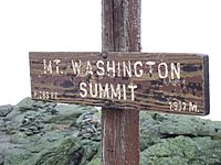
Mount Washington is a very tall mountain in New Hampshire, U.S.. It is the highest peak in the Northeastern United States, standing at 6,288.2 ft (1,916.6 m). It is also the most prominent mountain east of the Mississippi River. This means it stands out a lot from the land around it.
The mountain is famous for its wild and changing weather. On April 12, 1934, the Mount Washington Observatory measured a wind speed of 231 miles per hour (372 km/h) at the top. This was a world record until 1996. Mount Washington still holds the record for the highest wind speed measured that was not from a tornado or tropical cyclone.
Mount Washington is in the Presidential Range of the White Mountains. It is located in Coös County, New Hampshire. The very top of the mountain is in a place called Sargent's Purchase. Most of the mountain is part of the White Mountain National Forest. However, a small area of 60.3 acres (24.4 ha) around the summit is a special place called Mount Washington State Park.
You can reach the top of Mount Washington in a few ways. The Mount Washington Cog Railway goes up the western side. The Mount Washington Auto Road climbs to the summit from the east. Many hikers also visit the mountain using different trails, including the famous Appalachian Trail. Other fun activities include glider flying, backcountry skiing, and yearly races like the bicycle race and running race.
Contents
History of Mount Washington

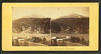
Stereoscopic photo of the summit of Mount Washington and a Glen House stage coach (around 1872). You can see the cog railway and the Summit House.
|
Before Europeans came, Native American people had different names for the mountain. Some called it Kodaak Wadjo, meaning "the top is so hidden." Others called it Agiochook, which meant "the place of the Great Spirit." The Abenaki people believed that mountain tops were where gods lived. Because of this, they did not climb them out of respect.
In 1524, Giovanni da Verrazzano was the first European to mention the mountain. He saw it from the Atlantic Ocean. He described it as "high interior mountains."
In 1642, Darby Field said he was the first European to climb Mount Washington. He climbed it to show the Abenaki chief Passaconaway that Europeans were not afraid of the mountain's gods. This helped colonists move north. Field climbed it again in October 1642 to help make maps of the land.
In 1784, a group of geologists led by Manasseh Cutler gave the mountain its current name.
In 1819, the Crawford Path was created. This path goes from Crawford Notch to the summit. It is the oldest hiking path in the United States that has been used continuously. Abel Crawford led the first group to use this path on September 10, 1819.
On August 31, 1821, three sisters from Jefferson, New Hampshire, became the first White women to reach the top. Their names were Eliza, Harriet, and Abigail Austin. This was likely the first time any Euro-American women climbed a major mountain in the U.S.
In 1821, Ethan Allen Crawford built a house on the summit. A storm destroyed this house in 1826.

Not much happened on the summit until the mid-1800s. Then, it became one of the first tourist spots in the country. More paths were built, along with two hotels. The Summit House opened in 1852. It was a 64-foot-long (20 m) stone hotel held down by heavy chains. In 1853, the Tip-Top House was built to compete. The Summit House was rebuilt in wood in 1872–1873 but burned down in 1908. A new granite Summit House was built in 1915. Only the Tip-Top House survived the fire. Today, it is a historic site with exhibits.
Other attractions from the Victorian era include a coach road (1861), now the Mount Washington Auto Road. The Mount Washington Cog Railway (1869) also opened. Both are still used today.
For 40 years, until 1917, a newspaper called Among the Clouds was printed on the summit each summer.
What is the weather like on Mount Washington?
| Weather chart for Mount Washington | |||||||||||||||||||||||||||||||||||||||||||||||
|---|---|---|---|---|---|---|---|---|---|---|---|---|---|---|---|---|---|---|---|---|---|---|---|---|---|---|---|---|---|---|---|---|---|---|---|---|---|---|---|---|---|---|---|---|---|---|---|
| J | F | M | A | M | J | J | A | S | O | N | D | ||||||||||||||||||||||||||||||||||||
|
6.4
14
-4
|
6.8
15
-2
|
7.7
21
5
|
7.4
30
17
|
8.2
41
30
|
8.4
50
40
|
8.8
54
44
|
8.3
53
43
|
8
47
36
|
9.3
36
24
|
9.9
28
13
|
7.7
18
2
|
||||||||||||||||||||||||||||||||||||
| temperatures in °F precipitation totals in inches source: NOAA |
|||||||||||||||||||||||||||||||||||||||||||||||
|
Metric conversion
|
|||||||||||||||||||||||||||||||||||||||||||||||
The top of Mount Washington has an alpine climate or tundra climate. This means it is very cold, like the Arctic. It also gets a lot of rain and snow. Lower parts of the mountain have a subarctic climate. Even lower down, it becomes a humid continental climate.
Mount Washington's weather is known for being very unpredictable. This is because different storm paths meet there. The mountain range also blocks westerly winds. This causes strong winds and ice at the top. These extreme conditions mean that trees cannot grow very tall, even at 4,400 feet (1,300 m) elevation.
Mount Washington once held the world record for wind speed. On April 12, 1934, winds of 231 mph (372 km/h) were measured. This is still the record for the Northern Hemisphere and Western Hemisphere. A new world record was set in 1996 by a tropical cyclone in Australia.
The first regular weather observations on Mount Washington started in 1870. The U.S. Signal Service ran the station. It was the first of its kind in the world. The coldest temperature ever recorded on Mount Washington was −50 °F (−45.6 °C) on January 22, 1885. Temperatures of 0 °F (−18 °C; 255 K) or below happen about 13 days a year.
On January 16, 2004, the temperature was −43.6 °F (−42.0 °C). Winds were 87.5 mph (140.8 km/h). This made the wind chill feel like −102.59 °F (−74.8 °C). For 71 hours in January 2004, the wind chill never went above −50 °F (−45.6 °C). The highest temperature ever recorded at the summit was 72 °F (22.2 °C) on June 26, 2003, and August 2, 1975.
In February 2023, the mountain set a new U.S. record for the lowest wind chill. It felt like −108 °F (−77.8 °C). This happened with winds over 100 miles per hour (160 km/h) and a temperature of −47 °F (−43.9 °C).
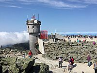
The main building on the summit is built to handle 300 mph (480 km/h) winds. Other buildings are chained to the mountain. The mountain is home to the Mount Washington Observatory. This is a non-profit group that studies the weather. They also test new weather tools. The Sherman Adams summit building is closed to the public in winter. Hikers can only go inside on special guided tours.
The Mount Washington Observatory was built in 1932. It has been collecting weather data ever since. They use a simple tool called a sling psychrometer to measure temperature and humidity. This helps keep their long-term weather records very accurate.
The observatory uses the slogan "Home of the World's Worst Weather." This idea came from an article in 1940. The article said Mount Washington probably did not have the absolute worst weather, but the slogan stuck!
Image gallery
-
Mount Washington Observatory
-
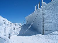
This building is chained to the ground. It is covered in rime ice in early April.
-
The top of Mount Washington is often hidden by clouds.


How much does it rain and snow?
_-_MOUNTWASHINGTON,_NH.svg)
Mount Washington gets a lot of rain and snow. This is because it is so tall and in a place where storm paths meet. It gets about 91.2 in (2,320 mm) of rain each year. The most rain in one year was 130.14 in (3,305.6 mm) in 1969. The least was 71.34 in (1,812.0 mm) in 1979.
A lot of this precipitation falls as snow. The mountain gets about 280 inches (7.1 m) of snow each winter. The most snow in one winter was 566.4 in (14.39 m) in 1968–69. The record for snow in 24 hours was 49.3 in (125.2 cm) in February 1969. That month was also the snowiest ever, with 172.8 in (4.39 m) of snow.
| Climate data for Mount Washington, elev. 6,267 ft (1,910.2 m) near the summit (1991–2020 normals, extremes 1933–present) | |||||||||||||
|---|---|---|---|---|---|---|---|---|---|---|---|---|---|
| Month | Jan | Feb | Mar | Apr | May | Jun | Jul | Aug | Sep | Oct | Nov | Dec | Year |
| Record high °F (°C) | 48 (9) |
48 (9) |
54 (12) |
60 (16) |
66 (19) |
72 (22) |
71 (22) |
72 (22) |
69 (21) |
62 (17) |
52 (11) |
47 (8) |
72 (22) |
| Mean maximum °F (°C) | 38.7 (3.7) |
35.6 (2.0) |
40.8 (4.9) |
49.0 (9.4) |
58.8 (14.9) |
64.5 (18.1) |
65.4 (18.6) |
64.2 (17.9) |
61.4 (16.3) |
53.8 (12.1) |
45.8 (7.7) |
39.8 (4.3) |
67.2 (19.6) |
| Mean daily maximum °F (°C) | 14.9 (−9.5) |
14.8 (−9.6) |
20.8 (−6.2) |
30.7 (−0.7) |
42.5 (5.8) |
51.4 (10.8) |
55.3 (12.9) |
54.2 (12.3) |
49.1 (9.5) |
37.7 (3.2) |
28.4 (−2.0) |
20.1 (−6.6) |
35.0 (1.7) |
| Daily mean °F (°C) | 5.8 (−14.6) |
5.9 (−14.5) |
12.9 (−10.6) |
23.7 (−4.6) |
36.3 (2.4) |
45.5 (7.5) |
49.9 (9.9) |
48.7 (9.3) |
43.1 (6.2) |
31.3 (−0.4) |
20.8 (−6.2) |
11.8 (−11.2) |
28.0 (−2.2) |
| Mean daily minimum °F (°C) | −3.2 (−19.6) |
−3.0 (−19.4) |
4.9 (−15.1) |
16.7 (−8.5) |
30.2 (−1.0) |
39.6 (4.2) |
44.5 (6.9) |
43.2 (6.2) |
37.1 (2.8) |
24.9 (−3.9) |
13.1 (−10.5) |
3.5 (−15.8) |
21.0 (−6.1) |
| Mean minimum °F (°C) | −28.6 (−33.7) |
−25.2 (−31.8) |
−19.4 (−28.6) |
−1.1 (−18.4) |
14.0 (−10.0) |
25.7 (−3.5) |
34.4 (1.3) |
31.4 (−0.3) |
21.3 (−5.9) |
8.3 (−13.2) |
−5.8 (−21.0) |
−20.8 (−29.3) |
−32.3 (−35.7) |
| Record low °F (°C) | −47 (−44) |
−47 (−44) |
−38 (−39) |
−20 (−29) |
−2 (−19) |
8 (−13) |
24 (−4) |
20 (−7) |
9 (−13) |
−5 (−21) |
−26 (−32) |
−46 (−43) |
−47 (−44) |
| Average precipitation inches (mm) | 5.74 (146) |
5.45 (138) |
6.72 (171) |
7.31 (186) |
7.68 (195) |
8.59 (218) |
8.93 (227) |
7.72 (196) |
7.66 (195) |
9.99 (254) |
8.09 (205) |
7.35 (187) |
91.23 (2,317) |
| Average snowfall inches (cm) | 41.4 (105) |
43.3 (110) |
46.2 (117) |
33.1 (84) |
12.9 (33) |
1.3 (3.3) |
0.0 (0.0) |
0.1 (0.25) |
1.2 (3.0) |
19.0 (48) |
35.6 (90) |
47.7 (121) |
281.8 (716) |
| Average extreme snow depth inches (cm) | 14.1 (36) |
16.3 (41) |
17.6 (45) |
14.5 (37) |
6.1 (15) |
0.5 (1.3) |
0.0 (0.0) |
0.0 (0.0) |
0.3 (0.76) |
5.7 (14) |
8.3 (21) |
12.7 (32) |
21.0 (53) |
| Average precipitation days (≥ 0.01 in) | 20.0 | 18.3 | 19.7 | 18.3 | 17.4 | 17.6 | 17.5 | 15.5 | 13.7 | 18.1 | 19.2 | 21.0 | 216.3 |
| Average snowy days (≥ 0.1 in) | 19.6 | 18.1 | 18.0 | 14.1 | 6.5 | 1.2 | 0.2 | 0.2 | 1.3 | 9.9 | 15.1 | 19.7 | 123.9 |
| Mean monthly sunshine hours | 92.0 | 106.9 | 127.6 | 143.2 | 171.3 | 151.3 | 145.0 | 130.5 | 127.2 | 127.1 | 82.4 | 83.1 | 1,487.6 |
| Percent possible sunshine | 32 | 36 | 34 | 35 | 37 | 33 | 31 | 30 | 34 | 37 | 29 | 30 | 33 |
| Source 1: NOAA (sun 1961–1990) | |||||||||||||
| Source 2: Mount Washington Observatory (extremes 1933–present) | |||||||||||||
What are the geographical features?
The western side of Mount Washington, where the Cog Railway goes, is quite straight. But the other sides are more complex. On the north side, the Great Gulf is a large bowl-shaped valley. It is surrounded by other tall peaks like Mounts Clay, Jefferson, Adams, and Madison. These peaks are so high that they are above the treeline. Chandler Ridge extends northeast from the summit. It forms the southern wall of this valley. The Mount Washington Auto Road climbs this ridge.
East of the summit is a flat area called the Alpine Gardens. It is about 5,200 feet (1,600 m) high. This area has special plants that grow in alpine meadows. These plants are also found in colder, arctic regions far to the north. The Alpine Gardens drop sharply into two other valleys. Craggy Huntington Ravine is a place for rock and ice climbing. More rounded Tuckerman Ravine is famous for spring backcountry skiing as late as June. It is also a beautiful hiking route.
South of the summit is another large alpine area called Bigelow Lawn. It is 5,000 feet (1,500 m) to 5,500 feet (1,700 m) high. Other peaks like Boott Spur and the Montalban Ridge extend south from it. The higher Southern Presidentials—Mounts Monroe, Franklin, Eisenhower, Pierce, Jackson, and Webster—go southwest. Oakes Gulf separates these two high ridges.
What can you do on Mount Washington?

Mount Washington is a popular place for hiking. The Appalachian Trail passes near the summit. One of the Appalachian Mountain Club's mountain huts, the Lakes of the Clouds Hut, is on one of the mountain's shoulders.
In winter, Tuckerman Ravine is a famous spot for skiing. People ski its 50-degree slopes as late as Memorial Day. This ravine is known for its avalanches. About 100 avalanches happen here every year. Six people have died in avalanches since 1849. Many hikers have also died on the mountain in all seasons. This is often due to bad weather, not enough gear, or not planning for the fast-changing conditions above the tree line.
The weather on Mount Washington also makes it a good place for glider flying. In 2005, it was named the 14th National Landmark of Soaring.
Hiking trails


The most common way to hike to the summit is using the 4.1-mile (6.6 km) Tuckerman Ravine Trail. It starts at the Pinkham Notch camp area. This trail climbs 4,280 feet (1,300 m) straight up the bowl of Tuckerman Ravine. It has steep rock steps and offers great views. Sadly, some people have died on this trail from ski accidents or hypothermia. You can refill water bottles at the base of the bowl, 2.1 miles (3.4 km) up the trail. There's a well pump near the Hermit Lake Shelters, which also has snacks and toilets. At the summit, there is a center with a museum, gift shop, and cafeteria.
Other trails on the eastern side include the Lion Head, Boott Spur, Huntington Ravine, and Nelson Crag trails. The Great Gulf Trail comes from the northeast. From the western side, you can use the Ammonoosuc Ravine and Jewell trails. The Crawford Path and Gulfside Trail are also popular.
Hiking Mount Washington in winter is very different from summer. There are no public buildings open on the summit in winter. The most common winter route is the Lion Head Winter Route. This trail starts on the Tuckerman Ravine Trail but then turns north. It goes up to Lion Head at 5,033 feet (1,534 m). This winter route helps climbers avoid dangerous avalanches. The exact path depends on how much snow there is.
Cog railway
Since 1869, the Mount Washington Cog Railway has taken tourists to the summit. It uses a special gear system called a Marsh rack system. It was the first successful rack railway in the U.S.
Races on the mountain
Every June, the Mount Washington Road Race takes place. Hundreds of runners compete in this event. In August, the Mount Washington Auto Road Bicycle Hillclimb is held. This bicycle race uses the same route as the running race. Famous cyclists like Tyler Hamilton have competed.
On August 7, 1932, Raymond E. Welch became the first one-legged man to climb Mount Washington. There was even a special race just for one-legged people. Mr. Welch climbed the "Jacob's Ladder" route. He then came down the carriage road.
The mountain also hosts one of the oldest car races in the country. The Mount Washington Hillclimb Auto Race has been held on and off since 1904. Travis Pastrana set new records in 2010, 2014, 2017, and 2021. He drove a Subaru WRX STi to a record time of five minutes and 28.67 seconds. In 2014, an electric car from Entropy Racing was the first electric car to race at Mount Washington.
Backcountry skiing
Tuckerman Ravine is a bowl-shaped valley on the mountain's southeast side. It is a very popular place for backcountry skiing. Tens of thousands of skiers visit it every year. People have skied down the headwall since 1931. The ravine quickly became an important spot for extreme skiing in New England.
In 1937, the mountain hosted the first giant slalom race in the United States. It was called the Franklin Edson Memorial Race.


Transmission facilities
.jpg)
Because Mount Washington is the highest point in the northeast U.S., it's a good place for radio and TV stations. These stations need to send signals over a large area. In 2003, it was reported that the summit was used by three commercial radio stations. It was also used by many state, federal, and private groups, like the state police.
Using the mountain for broadcasting started in the 1930s. People began to explore setting up radio stations that used "Very High Frequency" (VHF) signals. These signals usually only travel in a straight line. So, broadcasting from the top of Mount Washington was perfect for covering a wide area.
One of the first experimental stations was W1XER. It was moved to the mountain in 1937. It first helped relay weather information. With help from Edwin Howard Armstrong, it became an FM radio station. It started regular broadcasts on December 19, 1940. This station helped build the first broadcast tower and other buildings.
In 1954, WMTW, a TV station, built a TV tower and transmitter on the mountain. It started broadcasting from there. WMTW served as the ABC network station for many areas. This was thanks to its wide coverage. The station moved its transmitter away from the mountain in 2002.
Today, there are two FM radio stations on the mountain. In 1958, WMTW-FM 94.9 MHz (now WHOM) was built. Another station, WMOU (now WPKQ), moved to the summit in 1987. It built a new, taller broadcast tower.
On February 9, 2003, a big fire broke out in the generator room of a transmitter building. This building was owned by the state. The fire destroyed the building and the main generators. It also spread to another building, destroying it too. This cut off all power to the summit. Temporary generators had to be brought up the mountain. Later, power cables were installed in 2009. This brought electricity from the main power grid to the summit for the first time.
The original Armstrong tower still stands today. The Yankee Building also remains. It is still used for communications, including cell phone services and public safety radios.
The National Weather Service (NWS) operates NOAA Weather Radio station KZZ41 from the summit. This station can be heard in most of New Hampshire, western Maine, and parts of Vermont and Canada.
In 2008, there was talk of television returning to Mount Washington. New Hampshire Public Television wanted to move WLED-TV to the old WMTW mast on the summit.
Deaths on the mountain
More than 161 people have died in the Presidential Range since 1849. Author Nicholas Howe wrote a book called Not Without Peril. It talks about many of these deaths. The book says that many deaths happened because people did not plan well. They also did not understand how different the weather is in the mountains compared to cities. The mountains are farther north, inland, and much higher.
William Buckingham Curtis, who helped start American amateur sports, died on June 30, 1900. He died from exhaustion near Lakes of the Clouds Hut during a summer snowstorm.
Artistic tributes
Mount Washington has been featured in many famous paintings. These paintings are part of a style called White Mountain art. Artists in the Victorian era came to the White Mountains to paint nature. Train service made it easier for tourists to visit. The Glen House hotel was built, where artists like Albert Bierstadt stayed. Photographers also took many pictures of the scenery.
-
Mount Washington from Glen House in a stereographic image by John P. Soule.
-
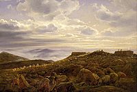
Painting by Ferdinand Richardt (1857).
-
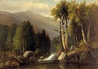
Painting by Benjamin Champney.
-
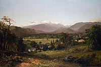
Painting by John F. Kensett (1869).
-
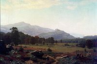
Painting by Albert Bierstadt (1858).


.jpg)

See also
 In Spanish: Monte Washington para niños
