North Stonington, Connecticut facts for kids
Quick facts for kids
North Stonington, Connecticut
|
||
|---|---|---|
|
Town
|
||
| Town of North Stonington | ||
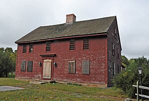
John Randall House, built in 1690
|
||
|
||
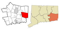 New London County and Connecticut New London County and Connecticut |
||
| Country | ||
| U.S. state | ||
| County | New London | |
| Region | Southeastern CT | |
| Incorporated | 1807 | |
| Government | ||
| • Type | Selectman-town meeting | |
| Area | ||
| • Total | 55.0 sq mi (142.4 km2) | |
| • Land | 54.3 sq mi (140.7 km2) | |
| • Water | 0.7 sq mi (1.7 km2) | |
| Elevation | 384 ft (117 m) | |
| Population
(2020)
|
||
| • Total | 5,149 | |
| • Density | 93.62/sq mi (36.159/km2) | |
| Time zone | UTC−5 (Eastern) | |
| • Summer (DST) | UTC−4 (Eastern) | |
| ZIP Code |
06359
|
|
| Area code(s) | 860/959 | |
| FIPS code | 09-55500 | |
| GNIS feature ID | 0213480 | |
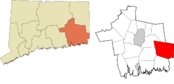
North Stonington is a town located in New London County, Connecticut, in the United States. It became its own town in 1724, splitting off from Stonington. This town is part of the Southeastern Connecticut Planning Region. In 2020, about 5,149 people lived here.
Contents
Geography of North Stonington
North Stonington covers a total area of about 55.0 square miles (142.4 km²). Most of this area, 54.3 square miles (140.7 km²), is land. Only a small part, 0.7 square miles (1.7 km²), is water.
Main Communities in North Stonington
The town includes several small communities:
- Clarks Falls
- Laurel Glen
- North Stonington Village
- Route 49
Historic Places in North Stonington
Several important places in North Stonington are listed on the National Register of Historic Places. This means they are recognized for their historical importance.
- John Randall House – This house is located southeast of North Stonington on Route 2. It was added to the list in 1978.
- North Stonington Village Historic District – This area includes Route 2, Main Street, Wyassup, Babcock, Caswell, and Rocky Hollow Roads. It was added on April 17, 1983.
- Samuel Miner House – This house is north of North Stonington, off Route 2 on Hewitt Road. It was added on July 18, 1976.
History of North Stonington
Let's explore the interesting history of North Stonington, from its early days to modern times.
Early Days: Before the 1600s
The land where North Stonington now stands is in the southeast corner of Connecticut. Before the 1600s, the Pequots, Niantics, and Narragansetts lived in this area. Not much is known about their daily lives in North Stonington before English settlers arrived.
The Pequot people left their mark on the town. The first European settlers kept many of their names for local natural features. These include Shunock Brook, Assekonk Swamp, and Wintechog and Cossaduck hills. Later, two reservations were set aside for the Pequot tribe. One was on the eastern side of Long Pond, near Lantern Hill, in 1683.
Colonial Times and the Revolutionary War: 1670s–1770s
For a long time in the 1600s, North Stonington was not very populated. English settlements started along the coast in the 1630s and 1640s. These were in places like Wequetequock (now Old Mystic) and Pawcatuck. As more people arrived, they began to move northward. After King Philip's War in 1676, and with border disputes settled, more settlers moved inland.
The first settlers in North Stonington were Ezekiel Main and Jeremiah Burch in 1667. They started communities in what became North Stonington Village and Clark's Falls. Other families soon followed in the 1670s and 1680s. These included the Mains, Miners, Wheelers, Browns, Palmers, Hewitts, and Averys. John Swan and his family arrived in 1707, and Swantown Road is named after them.
For most of the 18th century, people focused on building homes and farms. This was a slow process. They had to clear huge, old trees and move large rocks. Roads slowly began to appear, replacing old cattle paths and Pequot trails. In 1753, surveyors mapped out the future Route 49. One of the workers was 16-year-old Silas Deane. He later became an important diplomat for the United States in France. In 1768, a weekly stagecoach service started between Norwich, Connecticut and Providence, Rhode Island. This route went through North Stonington and Pawcatuck, becoming Route 2.
Settlers found it hard to travel far to church every Sunday. This led to a new Congregational church being planned in the northern part of Stonington in 1717. This "North Society" set a boundary line that is still the border between North Stonington and Stonington today. In 1724, the Connecticut Assembly officially named the new town "North Stonington." A church was built in 1727. It got its first permanent minister, Rev. Joseph Fish, in 1731. This church was known as the "Black Church" because its wooden walls were never painted and turned dark.
The First Great Awakening, a religious movement, spread through the American colonies in the 1740s. This led to the rapid growth of the Baptist Church. North Stonington became a strong center for Baptists in Connecticut. Many people left Rev. Fish's church to join the new Baptist church, which was built in 1743. This was the first Baptist church for both Stonington and North Stonington.
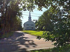
Another group left Rev. Fish's church in 1746 to form a "Strict Congregationalist Church." This caused a lot of sadness for Rev. Fish. Later, between 1817 and 1827, the Congregationalist and Strict Congregationalist churches joined together. They built a new church, which is the town's current Congregational Church.
The other two Baptist churches were formed more peacefully. The Second Baptist Church was started in 1765. The third Baptist Church was built in 1828. It served the many millworkers in North Stonington village.
Men from North Stonington fought in the French and Indian War in the 1760s. Many also joined the Revolutionary War. It's hard to know the exact number, as North Stonington was still part of Stonington. However, records show that many men joined the army. They fought in battles like the Battle of Long Island in 1776.
Three men from the North Society became important in the war:
- Thomas Wheeler helped defend Stonington Borough in 1775. He then led a company in New York in 1776.
- Elias Sanford Palmer was a lieutenant during the Long Island campaign. He continued to serve in the militia.
- Charles Hewitt was part of a group that captured British General Richard Prescott in Newport, Rhode Island, in 1777. Sadly, Hewitt died young from yellow fever in 1779.
Mills and Becoming a Town: Late 1700s to Mid-1800s
By the early 1700s, farmers in North Stonington began using the power of rivers and streams. They built grist mills (for grinding grain) and sawmills (for cutting wood). By the 1790s, after the United States became independent, many more mills appeared. Farmers were growing more crops and raising more livestock. They could sell these goods in other parts of Connecticut or even in Boston and the West Indies.
Mills grew quickly along the Shunock River in the village. This area became known as "Milltown." Landowners started selling plots for businesses and homes for millworkers. Smaller communities also grew, with their own churches, post offices, and stores. These included Clark's Falls, Laurel Glen, Ashwillet, and Pendleton Hill.
By the early 1800s, people in North Stonington felt different from those in the southern part of Stonington. The communities of Mystic, Stonington Borough, and Pawcatuck were far away. They were also more focused on the sea. The northern residents didn't want to pay for expensive projects along the coast. So, in April 1807, voters decided to split the town.
The State Assembly approved the split but did not like the proposed name "Jefferson." Instead, they named it "North Stonington." This was because the northern part of Stonington had been known by that name for almost a century. Some believe the Assembly's decision was also influenced by their dislike for President Thomas Jefferson.
In 1808, a survey of the town's assets showed it was mostly farmland. About 53% of the land was used for farming or pasture. The town had about 2,500 residents living in 750 homes. They owned many animals, including sheep, which were important for the growing wool business.
The survey also showed growing wealth. There were five stores, and some citizens owned fancy chaises (horse-drawn carriages) and clocks. Nine taverns served the townspeople and millworkers.
North Stonington played an active role in the War of 1812. Lieutenant Colonel William Randall, a resident, commanded the 30th regiment of Connecticut militia. His regiment helped defend Groton in 1813. In August 1814, they helped defend Stonington Borough when British warships attacked. During this battle, Lantern Hill got the nickname "Tar Barrel Hill." Soldiers lit barrels of pitch on its summit to signal alarms if British forces appeared in the Sound.
The 1820s and 1830s saw Milltown continue to grow as a business center. New mills were built for processing wool and leather. The town's population grew to over 2,800. In 1820, the New London-Providence Turnpike opened, which is now Route 184. This helped trade.
The Wheeler family became very wealthy during this time. Maj. Dudley Wheeler owned stores and was involved in the wool export business. The Wheelers later made large donations to the Congregational Church and the school system. In 1904, Wheeler's son Dwight donated one of the family's stores to become the town hall.
Another important businessman was Stephen A. Main. He owned mills and businesses. His home now houses the North Stonington Historical Society. Many beautiful homes were built during this time, and many still stand today.
However, the Industrial Revolution soon favored larger towns with bigger rivers. North Stonington's population began to drop after the 1830s. People moved to work in places like Westerly and Norwich. By 1870, the population was down to 1,759. Many young people also moved west to find new opportunities.
Civil War Era: Mills' Last Boom
Men from North Stonington joined several Connecticut regiments during the Civil War. Company "G" of the 21st Regiment of Connecticut Volunteers was made up entirely of North Stonington residents. This regiment fought in major battles like Battle of Fredericksburg and Battle of Drewry's Bluff. James F. Brown, from North Stonington, became the commander of the regiment. William S. Hubbel earned the Medal of Honor for capturing many Confederate soldiers.
The Civil War created a big demand for woolen products for the Army. This caused a temporary boom in mill activity in North Stonington. Alfred Clark built a large carding factory in Burch's Falls. This factory cost $34,000. It only lasted until 1895, but the community's name changed permanently to Clark's Falls. The old factory's foundation can still be seen today.
Quiet Rural Life: 1870s to 1930s
After the Civil War, North Stonington's population continued to shrink. By 1910, only 1,100 people lived there. Young people kept moving to cities or heading west. As people left, land prices dropped. Some farmers bought large areas of land. One such person, Lafayette Main, owned so much land that he said he had never even seen half of it.
Fewer people and new farming machines meant fewer farms. Forests slowly grew back, and today, much of the town is covered in trees.
Some people who left North Stonington became famous elsewhere. Samuel Prentice became Connecticut's Chief Justice. Otis Randall became a math professor and dean at Brown University. Ellen Fitz Pendleton was the sixth president of Wellesley College.
The Wheeler School and Library, built in 1901, offered free high school education. The library was on the second floor. In 1950, North Stonington replaced its 15 one-room schools with one main school for younger students. A new Wheeler High School opened in 1956. Today, the original building is still the town's library.
In the early 1900s, new transportation arrived. In 1906, a trolley line ran through North Stonington from Westerly to Norwich. The trolley ran for 15 years until the new Route 2 highway opened for cars. In 1933-34, Route 184 was built. This highway was very important for travel to Providence and Boston for many years.
North Stonington Today: 1940s and Beyond
The new paved highways helped North Stonington grow quickly after World War II. In the 1950s and 1960s, North Stonington became a "bedroom community." This means people lived there but worked in nearby defense industries and military bases. Companies like Electric Boat and Pfizer were in the area. The town's population grew a lot during these years.
In 1964, Interstate 95 was built with two exits in North Stonington. This made the town very easy to reach. Starting in the 1970s, "tech parks" opened near I-95. The rapid growth in population also meant the school system grew. Wheeler High School, however, remains one of the smallest high schools in Connecticut.
Because of this fast growth, citizens became worried about losing the town's rural feel. In 1963, planning and zoning rules were put in place. Population growth has continued, but at a slower pace. Today, the main challenge is balancing new commercial development with keeping the town's historic rural character.
North Stonington is close to Interstate 95 and, after 1992, to the Mashantucket casino in Ledyard. This has attracted many developers with ideas for entertainment parks. However, these plans have not yet been successful.
People who live in and visit North Stonington love its beauty and history. In 1983, the village was added to the National Register of Historic Places. This includes 58 homes and other buildings from the late 1700s and early 1800s. Two other houses in town, the homes of Luther Palmer and John Randall, are also on the register for their age and historical value.
Population Data
| Historical population | |||
|---|---|---|---|
| Census | Pop. | %± | |
| 1820 | 2,624 | — | |
| 1850 | 1,936 | — | |
| 1860 | 1,913 | −1.2% | |
| 1870 | 1,759 | −8.1% | |
| 1880 | 1,769 | 0.6% | |
| 1890 | 1,463 | −17.3% | |
| 1900 | 1,240 | −15.2% | |
| 1910 | 1,100 | −11.3% | |
| 1920 | 1,144 | 4.0% | |
| 1930 | 1,135 | −0.8% | |
| 1940 | 1,236 | 8.9% | |
| 1950 | 1,367 | 10.6% | |
| 1960 | 1,982 | 45.0% | |
| 1970 | 3,748 | 89.1% | |
| 1980 | 4,219 | 12.6% | |
| 1990 | 4,884 | 15.8% | |
| 2000 | 4,991 | 2.2% | |
| 2010 | 5,297 | 6.1% | |
| 2020 | 5,149 | −2.8% | |
| U.S. Decennial Census | |||
In 2000, there were 4,991 people living in North Stonington. These people lived in 1,833 households, with 1,424 of them being families. The town had about 91.9 people per square mile (35.5 per km²). There were 2,052 housing units.
About 35.0% of households had children under 18. Most households (65.7%) were married couples living together. About 7.7% were female-headed households with no husband present.
The population was spread out by age:
- 25.1% were under 18 years old.
- 6.4% were between 18 and 24.
- 29.8% were between 25 and 44.
- 28.3% were between 45 and 64.
- 10.4% were 65 years or older.
The average age in town was 40 years. For every 100 females, there were about 101.1 males.
The average income for a household in the town was $57,887. For families, it was $61,733. Males earned more than females on average. The average income per person in the town was $25,815. About 4.8% of the population lived below the poverty line. This included 5.1% of those under 18.
Images for kids
See also
 In Spanish: North Stonington para niños


