
Northland temperate forests facts for kids
Quick facts for kids Northland temperate forests |
|
|---|---|

Egmont National Park
|
|

Ecoregion territory (in purple)
|
|
| Ecology | |
| Realm | Australasian |
| Biome | temperate broadleaf and mixed forests |
| Borders | Northland temperate kauri forests |
| Geography | |
| Area | 84,041 km2 (32,448 sq mi) |
| Country | New Zealand |
| Regions | Bay of Plenty, Gisborne, Hawke's Bay, Manawatū-Whanganui, Taranaki, Waikato, and Wellington |
| Conservation | |
| Protected | 16,274 km² (19%) |
The Northland temperate forests, also called the North Island temperate forests, are a special type of forest found on New Zealand's North Island. These forests are known as temperate broadleaf and mixed forests, meaning they have a mix of trees that keep their leaves all year and trees that lose them. This amazing ecoregion covers most of the North Island, from the coast all the way up to tall volcanic mountains.
Contents
Exploring the Geography of North Island Forests
This forest area covers about 84,041 square kilometers (32,448 square miles). It stretches from the sea up to very high volcanic peaks. The very northern parts of the island, like the Northland Peninsula and Coromandel Peninsula, are part of a different forest type called the Northland temperate kauri forests.
Volcanoes and Lakes
The middle of the North Island has a large area called the North Island Volcanic Plateau. Here, you'll find Lake Taupō, which is New Zealand's biggest lake. It sits in a huge bowl-shaped hole called a caldera. This caldera was formed by a massive volcanic eruption about 2,000 years ago.
South of Lake Taupō, there are three important volcanic peaks:
- Mount Tongariro (1,978 meters or 6,490 feet tall)
- Mount Ngauruhoe (2,291 meters or 7,516 feet tall)
- Mount Ruapehu (2,797 meters or 9,177 feet tall)
Much of this plateau is covered by old lava flows, volcanic mudflows (called lahars), and ash from past eruptions.
Mount Taranaki
Mount Taranaki is an active volcano on the western side of the island. It stands 2,518 meters (8,261 feet) tall.
Mountain Ranges and Coasts
A chain of folded mountains runs along the east coast. These include the Tararua Range and the Kaimanawa Range. They stretch from Wellington in the south to East Cape in the northeast. These mountains are mostly made of sedimentary rock called greywacke. This is different from the volcanic rocks found on the plateau.
There are also flat coastal areas along the eastern, western, and northern shores of the island.
Amazing Plants of the North Island Forests
The forests here are home to many unique plants. Different types of trees grow at different heights.
Lowland Forest Trees
In the lower areas, you'll find tall podocarps like rimu (Dacrydium cupressinum) and mataī (Prumnopitys taxifolia). These trees stand above a canopy of evergreen broadleaf trees. Some of these broadleaf trees include kamahi (Weinmannia racemosa) and tawa (Beilschmiedia tawa).
Middle-Elevation Forest Trees
Forests on the volcanic plateau, at middle heights, are mostly made up of podocarps. These include:
- Rimu
- Miro (Prumnopitys ferruginea)
- Mataī
- Totara (Podocarpus totara)
- Kahikatea (Dacrycarpus dacrydioides)
On Mount Taranaki, middle-elevation forests also have Hall's totara (Podocarpus laetus) and kaikawaka (Libocedrus bidwillii).
High-Elevation Plant Life
Higher up the mountains, you'll find forests of southern beech (Nothofagus) and open areas of tussock grasslands. Near the treeline, where trees stop growing, there are shrublands with tough-leaved plants like Olearia colensoi and Brachyglottis rotundifolia. Their strong leaves help them survive the mountain winds. Even higher, above the treeline, you'll mostly see tussock grasslands.
Unique Animals of the North Island Forests
This ecoregion is a home for several native animals that are now rare.
Birds and Bats
Some of the special animals living here include:
- The North Island brown kiwi (Apteryx mantelli), a famous flightless bird.
- The lesser short-tailed bat (Mystacina tuberculata), one of New Zealand's only native land mammals.
- The North Island kōkako (Callaeas wilsoni), a beautiful native bird.
Reptiles
Native reptiles found in these forests include:
- Whitaker's skink (Cyclodina whitakeri)
- Forest gecko (Mokopirirakau granulatus)
- Wellington green gecko (Naultinus punctatus)
Protecting the North Island Forests
Sadly, most of the original forests in this ecoregion are gone. In the lowlands, much of the forest has been cleared for farming. On the plateau, it has been replaced by pastures for animals and large farms of radiata pine trees. These pine trees were brought from California in the 1800s.
Challenges from New Animals
Before humans arrived in New Zealand, birds were the largest land animals. The only land mammals were bats. This ecoregion was once home to huge flightless birds called moa, the powerful Haast's eagle (Hieraaetus moorei), the flightless New Zealand swan (Cygnus sumnerensis), and the North Island goose (Cnemiornis gracilis).
When the Maori arrived around 1280, they hunted many of these large birds, including the moa, native swan, and native goose, until they became extinct. They also brought the Polynesian rat (Rattus exulans).
Later, in the 1800s, Europeans settled and brought more animals. These included:
- Black rats (Rattus rattus)
- Domestic cats (Felis catus)
- Norway rats (Rattus norvegicus)
- Stoats (Mustela erminea)
These new animals are predators that have caused a lot of harm to native birds and insects. Some native species now only survive on offshore islands where these new predators are not present.
Other introduced animals like goats and Common brushtail possums (Trichosurus vulpecula) eat a lot of the plants in the lowland forests. Possums have especially damaged kamahi and rata trees in low areas, and kaikawaka and Hall’s totara in the southern mountains.
Protected Areas
In 2017, it was found that about 16,274 square kilometers (6,283 square miles), or 19%, of this ecoregion is protected. This means these areas are set aside to help nature. Even outside these protected areas, about 48% of the remaining land is still forested.
Important protected areas include:
- Tongariro National Park (788.53 km²) on the volcanic plateau.
- Egmont National Park (341.49 km²), which protects Mount Taranaki.
- Whanganui National Park on the western side of the plateau.
- Te Urewera (2090.72 km²) in the eastern highlands.
- Tararua Forest Conservation Park (1149.21 km²) in the south.
Images for kids
-
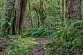
Egmont National Park
-
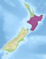
Ecoregion territory (in purple)
See also
 In Spanish: Bosques templados de la Isla Norte para niños
