
Partridge Island (Nova Scotia) facts for kids

Partridge Island is a cool place with lots of history, culture, and amazing rocks! It's located near the town of Parrsboro in Nova Scotia, right on the Minas Basin. Many people visit Partridge Island, including those who love sightseeing, swimming, taking photos, hiking, and even looking for cool rocks and fossils.
Partridge Island is actually a peninsula, which means it's land almost surrounded by water but connected to the mainland by a narrow strip of sand called an isthmus. People say this sandy connection was formed during a big storm called the Saxby Gale in 1869. If you hike to the top of the island, you'll get awesome views of famous spots like Cape Blomidon, Cape Split, and Cape Sharp.
There's a museum nearby called Ottawa House By-the-Sea. It has old items and displays that show what life was like in the village at Partridge Island, which started way back in the 1770s. Partridge Island is a favorite spot for "rockhounds" (people who love collecting rocks) because the strong tides of the Minas Basin constantly wear away its old sandstone and basalt cliffs. This erosion brings cool rocks and even gemstones, unique zeolite minerals, and fossils onto the beach. If you find fossils, remember that Nova Scotia law asks you to send them to a museum for study. You also can't dig fossils out of the solid rock without a special permit.
Contents
What's in a Name? Myths and Legends
Partridge Island got its name from a European translation of pulowech, which is the Mi'kmaq word for partridge. But the Mi'kmaq people themselves had a special name for the island: "Wa’so’q," meaning “Heaven.” This is because the island was a traditional place to gather amethyst, a beautiful purple stone they considered sacred.
The island was also believed to be the home of the grandmother of Glooscap, a legendary Mi'kmaq god-giant. According to Mi'kmaq artist Gerald Gloade, people also called Partridge Island "Glooscap's grandmother's cooking pot." This is because the water around the island looks like it's boiling twice a day! This happens when air trapped in holes in the basalt rocks is pushed out as the tide comes in.
Legend says Glooscap lived across the basin on Cape Blomidon. His amazing adventures explain many features of the landscape, including the huge tides of the Minas Basin. One story tells how his enemy, Beaver, built a giant dam across the Minas Channel. This dam flooded Glooscap's medicine garden and even the Annapolis Valley. Glooscap got angry, smashed the dam with his paddle, and released the trapped waters. This daily breaking and rebuilding of a giant beaver dam is a way to understand the powerful tides of the Minas Basin. It's not a real explanation, but a symbolic story about nature.
Early Days: A Crossroads by the Sea

For both the Mi'kmaq people and later European settlers, Partridge Island was a super important link to other parts of Nova Scotia. This was because it's located at one of the narrowest points on the Minas Basin. The Mi'kmaq name for the settlement at Partridge Island was Awokum, meaning "crossing-over point" or "short cut." In the 1730s, two French settlers even ran a ferry service that crossed the basin from Partridge Island.
A sign at the top of the Partridge Island hiking trail points out that many early Canadian historical events could have been seen from here. Imagine:
- The arrival of Nova Scotia's first peoples long ago.
- The French explorer Samuel de Champlain in 1607, who called the Minas Basin Le Bassin des Mines (The Basin of Mines) while looking for copper.
- The first Acadians sailing by in 1672 on their way to build dikes and farm the marshlands.
- The British ships arriving in 1755 to forcibly deport the Acadians.
- The arrival of New England Planters in the 1760s, who settled on the lands left empty by the Acadians.
A Busy Hub: Military and Trade
The village of Partridge Island started in the 1770s and was the original site of what is now Parrsboro. It had a military blockhouse (a small fort) on a high hill. This fort was important because it had a safe, deep-water spot for ships and a great view of any enemy ships in the Minas Basin.
After ferry service started again in 1764, Partridge Island stayed an important stop on the sea route to other parts of Nova Scotia, including the capital, Halifax. During the American Revolutionary War, an American privateer (a private ship allowed to attack enemy ships) captured the Partridge Island ferry. This cut off communication when American fighters were attacking Fort Cumberland. But British forces quickly got the ferry back and ended the attack, making sure Nova Scotia stayed loyal to Britain. The blockhouse at Partridge Island also got more weapons, like brass cannons, during the War of 1812.
Partridge Island was a busy and successful place in the late 1700s. The village had an inn, a tavern, a store, a school, and a church. It became a thriving trading center. Ships from all over the world would anchor there, bringing goods to the Ratchford family's store. This store then supplied manufactured products to every town and village on the Minas Basin.
Over time, the village started to decline. Politics played a big part. The Ratchfords were strong supporters of the Conservative party. When Joseph Howe from the Liberal party became the leader of Nova Scotia, the post office and customs house moved to Mill Village, which is where Parrsboro is today. Even after James Ratchford died in 1836, a Conservative Member of Parliament, Sir Charles Tupper, tried to help Partridge Island. He pushed for a large ferry wharf to be built there, which became known as "Tupper's Snag." Tupper even bought the Ratchford home and renamed it Ottawa House to show his support for Canadian Confederation. Today, not much is left of the old Partridge Island settlement, but the historic Ratchford/Tupper home is still there, now operating as the Ottawa House By-the-Sea Museum.
Amazing Rocks and Gems
Partridge Island sits on the edge of an ancient rift valley called the Fundy Basin. This valley formed when the huge supercontinent Pangaea started to break apart about 225 million years ago. As the continental plates moved away from each other, the Earth's crust cracked, and blocks of land dropped down along fault lines. These dropped areas became rift valleys, which then filled with sediments to form sedimentary basins. The Fundy Basin is the biggest of these basins in Eastern North America.
During the Triassic period (about 208 to 220 million years ago), heavy rains caused rivers to carry coarse sediments (now sedimentary rocks) from nearby highlands into the Fundy Basin. Other sediments came from wind-blown sand dunes. Later, large lakes formed in the middle of the basin, leaving behind finer sediments up to 1,000 meters thick. When these lakes dried up, they left behind salt and gypsum deposits.
The red sandstone at the base of Partridge Island is from the late Triassic period. The dark basalt layer on top was formed from magma and lava eruptions during the Jurassic period (about 175 to 208 million years ago). This happened as the continents continued to drift apart, further weakening the Earth's crust. Even though sandstone is soft and easily worn away, it forms tall, steep cliffs when it's covered by harder basalt.
The basalt cliffs of Partridge Island have small holes formed when gases escaped as the lava cooled. Water seeping through these holes deposited minerals, including gemstones like amethyst, agate, jasper, and calcite. You can also find zeolite minerals such as chabazite and stilbite at Partridge Island.
Dinosaur Footprints and Fossils
Since 1970, when a scientist named Paul E. Olsen found a neck bone from a long-necked dinosaur (a prosauropod) near Parrsboro, the north shore of the Minas Basin has been known as an important place for finding fossils. For example, in 1984, a rock collector named Eldon George found the world's smallest dinosaur footprints at Wasson Bluff, about 10 kilometers from Partridge Island. Then, in 1986, Olsen and his team announced they had found 100,000 fossilized bones, including some from the oldest dinosaurs ever found in Canada!
The cliffs at Partridge Island haven't had such huge fossil discoveries. However, Sarah Fowell, one of Olsen's students, found evidence in the rocks there about a mass extinction of ancient animals. This happened about 200 million years ago, at the time between the Triassic and Jurassic periods. She found a "rapid and dramatic change" from many different kinds of Triassic plants to far fewer kinds in the early Jurassic. Olsen thought her findings supported the idea that a giant asteroid hit the Earth, causing the mass extinction. This event then allowed dinosaurs to become the main animals on Earth. (Some scientists also think another asteroid collision wiped out the dinosaurs themselves much later.) More recently, however, scientists have suggested that huge volcanic eruptions might have caused these extinctions.
Hiking the Island Trail

The hiking trail on Partridge Island is about three kilometers (1.9 miles) round-trip. It climbs quickly to about 61 meters (200 feet) above sea level, but don't worry, there are four benches where you can rest! At the top of the trail, there's a viewing platform that gives you amazing views of over 60 kilometers (37 miles) of the Upper Minas Basin coastline. You can see famous spots like Cape Blomidon, Cape Split, Cape Sharp, Cape d'Or, and Cobequid Bay. At sunset, you can even spot many lighthouses around Partridge Island. Remember to stay on the trail and keep away from the edge of the cliffs, as they can be unstable.
Wildlife on Partridge Island
Partridge Island is home to many different kinds of wildlife, including both birds and mammals. You might see mammals like deer, weasels, skunks, porcupines, squirrels, and mice. Many types of birds also live here, such as owls, blue jays, hawks, eagles, and partridges. You can also hear various songbirds enjoying their time on the island.
The Amazing Tides
A sign at the Partridge Island hiking trail lookoff shares some incredible facts about the tides in the "Minas Gut." This is the section of the basin from Cape Blomidon to Cape Split and across to Partridge Island. The sign says that "100 billion tons of water" flow through this channel with each tide! It also mentions that more water passes through this channel every day than "the combined discharge of all the world's fresh water rivers." Imagine if we could use all that energy! The sign says harnessing this tidal energy could create enough electricity to power "250 medium sized nuclear power plants."
During each tide, more than eight cubic kilometers of water are pushed through a channel that's only about five kilometers (3.1 miles) wide. This causes the water levels inside the Minas Basin to rise and fall by 12 to 15 meters (39 to 49 feet)! The tidal currents in the channel can reach speeds of nearly 20 kilometers per hour (12.4 miles per hour).
The Bay of Fundy has the highest tides in the world, and the very highest of all happen right here in the Minas Basin. Several things make the Fundy tides so big, like the depth of the water and the shape of the coastline. These factors help create a natural "oscillation" or back-and-forth flow of water in Fundy that takes about half a day. This almost perfectly matches the half-day tidal cycle of the North Atlantic Ocean outside the bay. This matching cycle makes Fundy's tides incredibly high as water rushes in and out of the Bay.
Images for kids
-
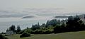
Partridge Island, shrouded in fog, viewed from the east across the mouth of Parrsboro Harbour from Greenhill

