Quinault Canyon facts for kids
Quick facts for kids Quinault Canyon |
|
|---|---|

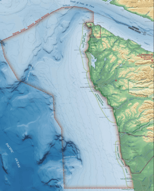
Quinault Canyon, at bottom, a bit left
|
|
| Coordinates | 47°21′00″N 125°08′00″W / 47.35°N 125.133333°W |
| Area | 378 square nautical miles |
The Quinault Canyon is a huge underwater valley, also known as a submarine canyon. It's located off the coast of Washington state in the Olympic Coast National Marine Sanctuary. Imagine a giant canyon on land, but deep under the ocean!
Contents
Where is Quinault Canyon?
This amazing underwater canyon is found right across from the Quinault Reservation. If you look at a map, you'll see the Quinault River flows into the Pacific Ocean right near the canyon.
Other places nearby include the Copalis National Wildlife Refuge and towns like Kalaloch, Queets, Taholah, Moclips, and Pacific Beach. You can also find Point Grenville, which is a piece of land sticking out into the sea. On land, Quinault, Washington and Lake Quinault are close by.
The Quinault Canyon is a very active place. Even though we can't easily see them, huge underwater landslides happen on its steep sides. The bottom of the canyon also collects lots of sand and mud that washes down from above.
How Big is the Canyon?
Quinault Canyon starts about 25 kilometres (16 mi) away from the shore. It covers a large area of 378 square nautical miles. That's a lot of underwater space!
Other Underwater Canyons Nearby
The Quinault Canyon is one of many underwater canyons in this area. If you travel from north to south, you'll find these other submarine canyons:
- Clayoquot Canyon
- Father Charles Canyon
- Loudon Canyon
- Barkely Canyon
- Nitinat Canyon
- Juan de Fuca Canyon
- Quileute Canyon
- Quinault Canyon
- Grays Canyon
- Guide Canyon
- Willapa Canyon
- Astoria Canyon
Among these local canyons, Quinault Canyon is the deepest. It reaches an amazing depth of 1,477 metres (4,846 ft)!
Volcanoes and the Canyon
Even though it's underwater, Quinault Canyon shows signs of past volcanic eruptions. Both the 1980 eruption of Mount Saint Helens and the ancient eruption of Mount Mazama (around 5677 BC) left behind layers of sediment called turbidites in the canyon. These layers are like clues telling us about those powerful events.
Quinault Canyon as a Pathway
Quinault Canyon acts like a giant funnel. It helps move sand and mud, called sediment, along Washington's continental shelf (the shallow part of the ocean floor near land). It's a main path connecting the continental shelf to the deep sea. Even tiny bits of silt and clay from the Columbia River travel all the way down into Quinault Canyon.
The canyon also brings cold, nutrient-rich seawater closer to shore. This process, called upwelling, brings important nutrients to the surface. These nutrients are like food for tiny ocean plants, which are at the very bottom of the ocean's food web.
Amazing Ocean Life
Because of the upwelling that brings so many nutrients, Quinault Canyon is a very important home for many different kinds of fish, invertebrates (like crabs and jellyfish), and even whales. The canyon has lots of boulders, tall walls, and ridges, which create great hiding spots and homes for sea creatures. Rockfish especially love these rocky areas.
Even though scientists haven't explored every part of the canyon yet, they have found at least 14 different types of animals, including:
- Corals
- Sponges
- Pennatulids (also known as sea pens), which include black coral and glass sponges.
Quinault Channel
The Quinault Canyon is connected to another deep-sea path called the Cascadia Channel by a special underwater route known as the Quinault Channel.
Exploring Quinault Canyon
As of August 2017, scientists started an exciting journey to explore Quinault Canyon, something that had never been done before! They used special underwater robots called Remotely operated underwater vehicles (ROVs) and autonomous underwater vehicles (AUVs) to explore Quinault and Quileute Canyons. These canyons are very interesting to scientists!
The main goals of this mission were:
- To map the homes of fish that the Quinault Nation relies on for fishing.
- To look for harmful algal blooms (when too many tiny plants grow in the water).
- To map the ocean floor.
- To check the levels of oxygen in the water.
- To study ocean acidification, which is when the ocean water becomes more acidic.
Methane Seeps
Scientists have also discovered methane seeps inside and near Quinault Canyon. These are places where natural gas (methane) bubbles up from the ocean floor.
 | Aaron Henry |
 | T. R. M. Howard |
 | Jesse Jackson |

