
Salem County, New Jersey facts for kids
Quick facts for kids
Salem County
|
|||
|---|---|---|---|

The Salem Nuclear Power Plant, as seen from Delaware Bay
|
|||
|
|||

Location within the U.S. state of New Jersey
|
|||
 New Jersey's location within the U.S. |
|||
| Country | |||
| State | |||
| Founded | 1694 | ||
| Named for | Hebrew word meaning "peace" | ||
| Seat | Salem | ||
| Largest municipalities | Pennsville Township (population) Lower Alloways Creek Township (area) |
||
| Area | |||
| • Total | 372.55 sq mi (964.9 km2) | ||
| • Land | 331.86 sq mi (859.5 km2) | ||
| • Water | 40.69 sq mi (105.4 km2) 10.9% | ||
| Population
(2020)
|
|||
| • Total | 64,837 | ||
| • Estimate
(2023)
|
65,338 |
||
| • Density | 174.036/sq mi (67.1956/km2) | ||
| Time zone | UTC−5 (Eastern) | ||
| • Summer (DST) | UTC−4 (EDT) | ||
| Congressional district | 2nd | ||


Salem County is a county located in the western part of New Jersey. It's known for being the westernmost county in the state. The Delaware River forms its western border. You can also find the start of the Delaware Memorial Bridge here, which connects New Jersey to New Castle, Delaware.
The main town, or county seat, is Salem. This county is part of the South Jersey area and is also close to the big city of Philadelphia. In 2020, Salem County had about 64,837 people, making it the least populated county in New Jersey. The town with the most people is Pennsville Township, while Lower Alloways Creek Township covers the largest area. Salem County is becoming a busy place for logistics (moving goods) and warehouse buildings.
Contents
History of Salem County
What Does "Salem" Mean?
The name "Salem" comes from the Hebrew word shalom, which means "peace". Early settlers, especially Quakers, chose this name because the area felt very calm and peaceful to them.
How Salem County Began
European settlers from England first arrived in the 1600s. They started a court here in 1681. Salem County was officially formed on May 17, 1694. It was part of an older area called the Salem Tenth within West Jersey.
The Old Salem County Courthouse is a very special building. It was built in 1735 and is the oldest courthouse still in use in New Jersey. It's also the second oldest courthouse in continuous use in the entire United States! The building has been made larger over the years, but its unique bell tower is still the same.
During the American Revolutionary War, an important event happened near here. A judge named William Hancock was killed by the British during the Salem Raid in 1778. After this, the courthouse was used for "treason trials." People suspected of helping the British were put on trial.
A fun legend from the courthouse involves tomatoes! Before 1820, many Americans thought tomatoes were poisonous. But in 1820, a man named Colonel Robert Gibbon Johnson supposedly stood on the courthouse steps and ate tomatoes in front of a big crowd to show they were safe to eat.
Salem County is also known for its special Quaker-style buildings from the 1700s. For a long time, it was mostly a farming area. In the early 1900s, many new people from Europe moved here. After World War II, more people moved to the county as towns grew. The Delaware Memorial Bridge was built to help with the increased traffic.
Geography and Climate
Where is Salem County Located?
Salem County covers about 372.55 square miles. Most of this area, about 331.86 square miles, is land. The rest, about 40.69 square miles, is water. The Delaware River is on its western side. Other smaller rivers and creeks, like the Salem River and Alloway Creek, also flow through the county.
The land in Salem County is mostly flat, like a coastal plain. The highest points are only about 160 feet above sea level. The lowest point is sea level itself.
What is the Weather Like?
Salem County has a humid subtropical climate. This means it has hot, humid summers and mild winters. In the county seat of Salem, average temperatures are around 33°F (0.5°C) in January and 77°F (25°C) in July.
| Weather chart for Salem, New Jersey | |||||||||||||||||||||||||||||||||||||||||||||||
|---|---|---|---|---|---|---|---|---|---|---|---|---|---|---|---|---|---|---|---|---|---|---|---|---|---|---|---|---|---|---|---|---|---|---|---|---|---|---|---|---|---|---|---|---|---|---|---|
| J | F | M | A | M | J | J | A | S | O | N | D | ||||||||||||||||||||||||||||||||||||
|
3
40
25
|
2.8
44
27
|
3.9
52
34
|
3.5
64
43
|
4
73
53
|
3.9
82
63
|
4.6
86
68
|
3.3
84
66
|
4.3
77
58
|
3.4
66
46
|
3.1
56
37
|
3.5
45
29
|
||||||||||||||||||||||||||||||||||||
| temperatures in °F precipitation totals in inches source: The Weather Channel |
|||||||||||||||||||||||||||||||||||||||||||||||
|
Metric conversion
|
|||||||||||||||||||||||||||||||||||||||||||||||
The average monthly rainfall ranges from about 2.78 inches in February to 4.57 inches in July. The coldest temperature ever recorded was -14°F (-25.5°C) in January 1985, and the hottest was 107°F (41.6°C) in August 1918.
Population of Salem County
| Historical population | |||
|---|---|---|---|
| Census | Pop. | %± | |
| 1790 | 10,437 | — | |
| 1800 | 11,371 | 8.9% | |
| 1810 | 12,761 | 12.2% | |
| 1820 | 14,022 | 9.9% | |
| 1830 | 14,155 | 0.9% | |
| 1840 | 16,024 | 13.2% | |
| 1850 | 19,467 | 21.5% | |
| 1860 | 22,458 | 15.4% | |
| 1870 | 23,940 | 6.6% | |
| 1880 | 24,579 | 2.7% | |
| 1890 | 25,151 | 2.3% | |
| 1900 | 25,530 | 1.5% | |
| 1910 | 26,999 | 5.8% | |
| 1920 | 36,572 | 35.5% | |
| 1930 | 36,834 | 0.7% | |
| 1940 | 42,274 | 14.8% | |
| 1950 | 49,508 | 17.1% | |
| 1960 | 58,711 | 18.6% | |
| 1970 | 60,346 | 2.8% | |
| 1980 | 64,676 | 7.2% | |
| 1990 | 65,294 | 1.0% | |
| 2000 | 64,285 | −1.5% | |
| 2010 | 66,083 | 2.8% | |
| 2020 | 64,837 | −1.9% | |
| 2023 (est.) | 65,338 | −1.1% | |
| Historical sources: 1790-1990 1970-2010 2010 2020 |
|||
In 2020, Salem County had 64,837 people. The population density was about 195 people per square mile. Most residents (79%) were White, and 13.1% were African American. About 9.8% of the population identified as Hispanic or Latino.
The average age of people in Salem County was 43.1 years old. About 21% of the population was under 18, and nearly 20% was 65 or older. The average household had 2.5 people.
Economy
In 2021, the total value of goods and services produced in Salem County was about $5.2 billion. This shows how much economic activity happens in the county.
Education
School Districts in Salem County
Salem County has several school districts that serve students from kindergarten through high school.
- Schools for all grades (K-12)
- Penns Grove-Carneys Point Regional School District
- Pennsville School District
- Pittsgrove Township School District
- Salem City School District
- Salem County Special Services School District
- Woodstown-Pilesgrove Regional School District
- High School Only
- Salem County Vocational Technical Schools
- Elementary Schools (K-8)
- Alloway Township School District
- Elsinboro Township School District
- Lower Alloways Creek Township School District
- Mannington Township School District
- Oldmans Township School District
- Quinton Township School District
- Upper Pittsgrove School District
Transportation

Salem County has many roads that help people get around. Major roads include U.S. Routes 40 and 130, and state routes like Route 45 and Route 49.
Two major highways, Interstate 295 and the New Jersey Turnpike, pass through the northern part of the county. The Turnpike has one exit in Salem County, Exit 1 in Carneys Point. There are also two rest stops on the Turnpike here: the John Fenwick Service Area and the Clara Barton Service Area.
The Delaware Memorial Bridge is a very important connection. It's actually two bridges that cross the Delaware River, linking Pennsville Township in Salem County to New Castle, Delaware. The first bridge opened in 1951, and the second in 1968.
NJ Transit also provides bus services in Salem County, with routes connecting to places like Philadelphia and other towns within the county.
Towns and Communities

Salem County has 15 different towns and townships, which are called municipalities. Some of these also have smaller, unincorporated communities or census-designated places (CDPs) within them.
- Alloway Township
- Communities: Aldine, Alloway CDP, Friesburg, Penton
- Carneys Point
- Community: Carneys Point CDP
- Elmer
- Elsinboro
- Lower Alloways Creek
- Community: Hancock's Bridge CDP
- Mannington Township
- Community: Marshalltown
- Oldmans Township
- Communities: Auburn CDP (part), Pedricktown CDP
- Penns Grove
- Pennsville Township
- Communities: Deepwater, Pennsville CDP
- Pilesgrove
- Community: Auburn CDP (part)
- Pittsgrove
- Communities: Brotmanville, Centerton, Norma, Olivet CDP
- Quinton Township
- Community: Quinton CDP
- Salem (the county seat)
- Upper Pittsgrove
- Communities: Daretown, Friendship, Monroeville, Whig Lane
- Woodstown
Fun Things to Do
Wineries
Salem County is home to several wineries where you can learn about and taste local wines:
- Auburn Road Vineyards
- Chestnut Run Farm
- Monroeville Vineyard & Winery
- Salem Oak Vineyards
Famous People from Salem County
- Whitey Witt – A former baseball player who was part of the New York Yankees team that won their first World Series in 1923.
Images for kids
-
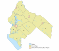
Index map of Salem County municipalities
See also
 In Spanish: Condado de Salem para niños
