
Somerton facts for kids
Quick facts for kids Somerton |
|
|---|---|
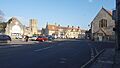
 Somerton's Market Square |
|

Somerton
|
|
| Population | 4,697 |
| OS grid reference | ST485285 |
| Civil parish |
|
| District | |
| Shire county | |
| Region | |
| Country | England |
| Sovereign state | United Kingdom |
| Post town | SOMERTON |
| Postcode district | TA11 |
| Dialling code | 01458 |
| Police | Avon and Somerset |
| Fire | Devon and Somerset |
| Ambulance | South Western |
| EU Parliament | South West England |
| UK Parliament |
|
Somerton is a historic town and civil parish in the English county of Somerset. It's special because the county of Somerset actually got its name from this town! For a short time around the early 1300s, Somerton was even the main county town. Around 900 AD, it might have been the capital of Wessex, an important Anglo-Saxon kingdom.
Somerton has had a weekly market since the Middle Ages. Its main square, with a special market cross, is a lovely spot for visitors today. The town sits near the River Cary, about 8.8 miles (14.2 km) north-west of Yeovil. Somerton has its own town council and was home to 4,697 people in 2011. People who live here are often called Somertonians. The area also includes small villages like Etsome, Hurcot, Catsgore, and Catcombe.
Somerton's history goes way back to the Anglo-Saxon times, when it was a key place for politics and business. After the Norman conquest of England, the town became less important. However, it was still the county town of Somerset for a while in the late 1200s and early 1300s. After losing its county town status, Somerton became a busy market town. Its economy grew thanks to transport on the River Parrett and later by train with the Great Western Railway. Local industries like glove making and gypsum mining also helped the town thrive.
In the heart of Somerton, you'll find a wide market square with an octagonal (eight-sided) roofed market cross. Old houses surround this square. Nearby is the Church of St Michael and All Angels, which dates back to the 1200s. Somerton also had connections with Muchelney Abbey during the Middle Ages. If you've ever seen the BBC show The Monocled Mutineer, you might recognize Somerton, as parts of it were filmed here between 1985 and 1986.
Contents
A Look Back: Somerton's History
The first mention of Somerton is in the Anglo-Saxon Chronicle. This old record says that in 733, King Æthelheard of Wessex lost control of Somerton to King Æthelbald of Mercia. Somerton was also the place where the witan (an Anglo-Saxon parliament) met in 949.
The town returned to West Saxon control in the 800s. It was listed in the Domesday Book of 1086 as "Sumertone". The name "Somerton" might come from Old English words meaning "sea-lake enclosure," "summer town," or "summer farmstead." The name "Somerton" was used for the people in the area it controlled, and this area became known as Somerset. Even though Somerton didn't become a huge city, it was briefly the county town of Somerset from the late 1200s to the early 1300s.
Old Buildings and Industries
The Abbots of Muchelney Abbey were in charge of Somerton's church during the Middle Ages. They built a tithe barn to store the tithes (a share of crops or produce) paid to the church. When the Abbey was closed in 1539 during the English Reformation, the barn became owned by Bristol Cathedral. In the 1900s, the barn was turned into private homes.

In the early 1800s, making gloves was a big industry in Somerton. Rope and twine were also produced. The Somerton Brewery, owned by Thomas Templeman, started around 1841. It became a large brewery in Somerset before closing around 1935. Before national health services, the Somerton Men's Club helped people in the area like a local insurance group.
Gypsum was dug out by hand at the Hurcott mine from the Victorian era until it closed in 1953. In 1906, a train station opened on the Castle Cary Cut-Off line, built by the Great Western Railway. The train line is still used today, but the station closed in 1962. In the 1920s, the Marconi Company built a radio receiving station in Somerton as part of a large wireless network.
Somerton During World War II
Somerton was bombed by four Luftwaffe planes on September 29, 1942, during World War II. The bombs were aimed at the Cow and Gate milk factory, which was mostly destroyed. Ten nearby houses were also badly damaged. Nine people died, and thirty-seven were injured. A memorial at the old factory site remembers those who were killed. The factory site later became a council depot and was recently bought by the town council. They might use it for a new town hall.
Somerton's Location and Climate
Somerton is located on a flat area of land, south of the deep valley of the River Cary. The river flows west and north through the Somerton Moor, eventually joining the River Parrett near Bridgwater. The town is 116 miles (187 km) from London, 28 miles (45 km) south of Bristol, and 9 miles (14 km) north-west of Yeovil. It's also close to the border with Dorset.
Small areas around Somerton include Etsome, Hurcot, Lower Somerton, Littleton, and Midney. Great Breach Wood is a special place for wildlife, called a biological Site of Special Scientific Interest (SSSI). It's just 1.4 miles (2.3 km) north-east of Somerton, near Littleton.
Somerton has a typical climate for south-west England. This means cool winters and warmer summers. It rains throughout the year, with more rain usually falling in winter.
 |
Somerset Levels | Glastonbury | Mendip Hills | |
| Bridgwater | Mendip Hills | |||
| Langport | Martock, South Petherton | Yeovil |
How Many People Live Here?
In 2002, the Somerton parish had a population of 4,706 people. In 1801, the town had 1,145 residents. The population grew a lot in the first half of the 1800s, reaching 2,140 in 1851. However, it then started to drop, falling to 1,917 by 1861. The population continued to fall until 1921. After that, it slowly started to grow again. It wasn't until 1961 that Somerton's population was higher than it was in 1851. Since then, the number of people living in Somerton has continued to increase steadily.
Famous Places in Somerton

The main square, called Market Place, with its market cross, is a popular spot for visitors. Market crosses have been in the square since before 1390. The current Butter Cross, which has a roof, was rebuilt in 1673. It's one of Somerton's most famous features. This structure used to belong to the Earls of Ilchester, who sold it to the town in 1916. It's now a Scheduled Ancient Monument, meaning it's protected for its historical importance.
Next to the Butter Cross is the "Market Hall," once called the "Town Hall." However, this building has never actually been used for either of those purposes! Around the square, you'll also find the church, the Lady Smith Memorial Hall (also known as the "Parish Rooms," built in 1902), and the 1600s Market House, which is now a restaurant. The Red Lion was a famous coaching inn opened in 1768. It closed in 1995 and has since been turned into town houses.
Since the early 1980s, efforts have been made to make Somerton more appealing for filming. The market square was updated, creating a central parking area close to local shops and services. As mentioned before, the BBC drama The Monocled Mutineer was filmed in Somerton from 1985 to 1986.
Somerton Court
Somerton Court was originally known as "Somerton Erleigh." This house has had many different owners. These include Edward IV's brother, the Duke of Clarence, and Henry Percy, 6th Earl of Northumberland. Henry Percy sold the estate in 1530. It changed hands several times until 1597, when James Fisher bought it. His son later rebuilt the house in 1641.
The Fisher family owned Somerton Court until 1808, when it was sold. The new owner renamed it "Somerton Court." They also changed its look, adding Gothic battlements and turrets instead of the original gabled dormers. The Hall-Stephenson family later made the house even bigger. During World War II, members of the Royal Navy WRENS stayed there. In the 1970s, a local businessman, Stuart Pattemore, bought it. In 1987, Roger Byron-Collins bought Somerton Court, along with its 55 acres of land and four cottages. He made many improvements and additions. It was sold again in 2005. The Dower House, one of the cottages, was built in the early 1800s. Today, Somerton Court is used for wedding receptions and stands on 55 acres of land.
Getting Around Somerton
Somerton's only train station was on the Castle Cary Cut-Off line, which was part of the Great Western Railway. Even though the train line is still used today, the station closed to passengers in 1962 and for goods in 1964. The closest train station now is at Castle Cary. On the edge of town, you can see the impressive Somerton Viaduct.
Even though Somerton is in a rural area, the closest main road is the A303. This road runs near the town and goes all the way into northern Hampshire, ending at Basingstoke. A smaller road, the B3165 road, goes through the town. However, it's not as commonly used and doesn't connect to the A303 for another 4 miles (6.4 km). Two B roads, the B3153 and B3165, pass through Somerton. The B3165 starts in town and goes south to the A372 Langport road. The A372 itself goes south-east to where the A303 and A37 roads meet at Podimore services.
Places of Worship

The Anglican Church, St Michael's and All Angels, began in the 1200s. It was largely reshaped in the mid-1400s and restored again in 1889. It's built from local lias stone with Hamstone decorations. English Heritage has given it a Grade I listed building status, meaning it's a very important historic building.
The church is famous for its carved roof, which features lions and a small cider barrel. People say monks from Muchelney Abbey carved them. The writer Sir John Betjeman was also inspired by words written on the candelabra (a large candle holder). The outside of the church looks quite simple, but inside, it has one of the most beautiful wooden carved roofs in the county. The roof is shallow with huge, richly decorated beams and short posts. The entire roof area is divided into 640 square carved panels, each with the same quatrefoil (four-leaf clover) design. In the triangular spaces above each beam, you can see dragon-like creatures. It's said that there are bullet holes in the timbers from soldiers who camped in the church in 1646 before the Battle of Langport. The pulpit (where the preacher stands) and altar table from the 1600s are examples of Jacobean woodwork. Somerton also has five other churches, including Catholic and Methodist groups.
Twin Towns
Somerton has special connections with two towns in other countries:
 Licciana Nardi, in Tuscany, Italy
 Sillé-le-Guillaume, in Pays-de-la-Loire, France
Images for kids
-
Somerton's Market Square
-
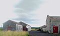
Disused radio station built by the Marconi Company around 1925
-
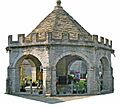
The Butter Cross which was rebuilt in 1673
-
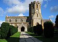
St Michael's and All Angels church has origins which date from the 13th century.
See also
 In Spanish: Somerton para niños
