South Petherton facts for kids
Quick facts for kids South Petherton |
|
|---|---|
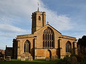 Church of St Peter and St Paul showing the octagonal tower. |
|
| Population | 3,737 |
| OS grid reference | ST435165 |
| • London | 131 mi (211 km) ENE |
| Civil parish |
|
| District | |
| Shire county | |
| Region | |
| Country | England |
| Sovereign state | United Kingdom |
| Post town | SOUTH PETHERTON |
| Postcode district | TA13 |
| Dialling code | 01460 |
| Police | Avon and Somerset |
| Fire | Devon and Somerset |
| Ambulance | South Western |
| EU Parliament | South West England |
| UK Parliament |
|
South Petherton is a large village in Somerset, England. It is located about 5 miles (8 km) east of Ilminster. The village is also 5 miles (8 km) north of Crewkerne. In 2021, about 3,737 people lived here. The area includes smaller places like Over Stratton and hamlets such as Compton Durville. The River Parrett flows along the eastern edge of the village.
Many buildings in South Petherton are made from a special local stone called hamstone. In 2005, South Petherton won the 'Somerset Village of the Year' award. Long ago, South Petherton was a market town. This means it had a regular market where people bought and sold goods. Today, it is known as a village, but it still has some features of a town.
Contents
Village History
The name South Petherton might come from old English words. Pared meant boundary, and ton meant settlement. So, it could mean 'boundary settlement'.
Archaeologists have found old items from the Iron Age near Lightgate Road. These show people lived here a very long time ago. Roman coins have also been found. This suggests Romans were in the area. The village is only 2 miles (3 km) from an old Roman road called the Fosse Way.
In 680, an old record called the Anglo-Saxon Chronicle mentions a big battle here. Later, Ine of Wessex, a Saxon king, built a palace on what is now Silver Street.
South Petherton was once a large royal estate. It was called Sudperetone, meaning 'the southern settlement on the Parrett river'. It had a church, a royal palace, and even a place to make coins for a short time. In 1086, after William the Conqueror took over England, most of this land still belonged to the King.
In 1213, King John allowed South Petherton to hold a market and a fair. Over time, the land was given to different families. The Daubeney family owned it for many years. Later, it went back to the Crown. Then, it was owned by the Arundell family until 1792.
During the English Civil War in the 1640s, soldiers from both sides stayed in the village. South Petherton also played a part in the Monmouth rebellion in 1680. Some villagers were put on trial after the rebellion.
It was recently found that in the 1600s, South Petherton was a main place for making bronze cooking pots. These pots were used all over the UK.
How South Petherton is Governed
South Petherton has a parish council. This council is made up of local people. They help manage local issues in the village. For example, they decide how much local tax (called a precept) is needed. They also check building plans and work with the police on safety and traffic. The council helps keep local facilities in good shape. They also talk to the larger district council about roads, paths, and public transport.
South Petherton is part of the South Somerset local government area. This is part of the bigger Somerset County Council area.
The village is also part of the Yeovil area for national elections. This area chooses one MP to represent them in the House of Commons in London. Since July 2024, the MP for Yeovil is Adam Dance. He is a member of the Liberal Democrats. He also lives in the village and is a local councillor.
Village Geography
South Petherton is located in a lovely area. To the west are the Blackdown Hills. To the north are the flat, wet lands of the Somerset Levels. To the south are the hills of Dorset. About 3 miles (5 km) east is Ham Hill. This is where much of the stone used for buildings in the village comes from.
The village sits on low, rolling land made of Yeovil Sands. It is at the bottom of a limestone ridge. This ridge has been used to get stone for building. It also has sands and clays for making bricks and tiles.
Weather in South Petherton
South Petherton has a mild and often wet climate. This is typical for South West England. The average yearly temperature is about 10°C (50°F). Summers are warmest in July and August, with temperatures around 21°C (70°F). In winter, temperatures can drop to 1°C or 2°C (34-36°F).
The area gets about 700 mm (28 inches) of rain each year. Most rain comes from storms moving in from the Atlantic Ocean. Snowfall is not very common, usually only 8 to 15 days a year. The wind usually blows from the south-west.
Local Economy
Farming has always been important in South Petherton. In the past, the village was also known for making gloves and cider. Many small home-based businesses existed here.
Making cloth was also a big industry until the late 1700s and 1800s. Later, this changed to making sailcloth and then working with leather. You can still see old mills that show how important this industry was. These include the former flax mill in Hayes End and Joylers Mill.
Important Landmarks
On Silver Street, there is a manor house from the 1300s. It was fixed up in the 1800s and is sometimes called 'King Ina's Palace'.
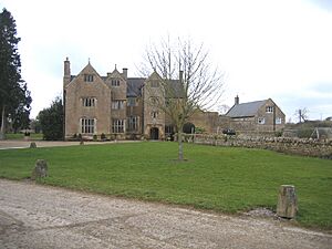
Wigborough Manor House was built in the 1400s or 1500s. It was never finished as planned and has been changed many times. It is a very important historic building.
About 1 mile (1.6 km) from South Petherton are the East Lambrook Manor Gardens. These gardens were created by Margery Fish. She was a famous gardener from the 1950s. The gardens have a special collection of geraniums and snowdrops.
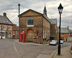
The "David Hall" is a local community center. It is in an old church building. The Petherton Arts Trust runs it. They are a charity that puts on different events. There is also "The Blake Hall." It has a social club and a hall upstairs. A market is held there once a month, along with other activities.
An old wall for playing Fives (a type of handball) still stands near Crown Lane. It is also a protected historic building.
Getting Around (Transport)
The main road, the A303, passes just south of South Petherton. You can get to the village from this road at Hayes End Roundabout.
The closest train stations are in Crewkerne and Yeovil. In the past, there were closer stations, but they closed in the 1960s. South Petherton has a coach service that goes to London twice a day. There is also a regular bus service to nearby towns like Montacute and Yeovil.
National Cycle Network Route 339 goes through the village. This route connects Langport with another cycle route. The River Parrett Trail, a walking path along the river, also passes through South Petherton.
Churches and Religious Sites
The Church of England Church of St Peter and St Paul has very old Saxon parts. It has a 13th-century section. Most of the church was built in the 1400s. It was also repaired a lot in the late 1800s and early 1900s. It is a very important historic building. The church tower is shaped like an octagon. It is thought to be the tallest octagonal church tower in the UK. It has twelve bells.
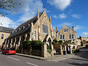
The Coke Memorial Methodist Church was built in 1881–82. It replaced an older church from 1809. It is named after Thomas Coke. He was a priest in the village from 1772 to 1776. He was very important in starting Methodism with John Wesley.
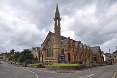
A United Reformed Church was built in 1863. This building is now the 'David Hall' and hosts many public events.
The village also has a Roman Catholic church. It is called St Michael's Church and is on Lightgate Road.
Sports and Activities
The South Petherton Walking Group is for people over 50. It helps residents and visitors enjoy walking and being social.
The Recreation Ground has fields for football and cricket clubs. There are also places to play tennis and bowls. A children's play area is also available. The football field is very large for the level of football played there. South Petherton Football Club was moved down a league in 2013 but quickly got promoted back up.
The Vaux Park Polo Club is located at Wigborough Manor. They use the grounds of the house for polo matches.
Famous People from South Petherton
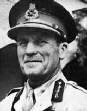
- John Harding, 1st Baron Harding of Petherton (1896–1989) was a famous soldier.
- John Brunner (1934–1995) was a science fiction writer.
- John Weston Parsons Peters (1864-1924) was a soldier and administrator.
See also
 In Spanish: South Petherton para niños
 | Madam C. J. Walker |
 | Janet Emerson Bashen |
 | Annie Turnbo Malone |
 | Maggie L. Walker |


