Ham Hill, Somerset facts for kids
Quick facts for kids Ham Hill |
|
|---|---|
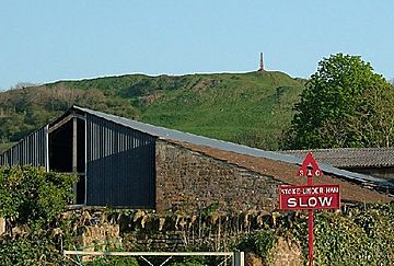
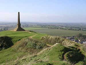
Ham Hill summit and war memorial seen from Stoke-sub-Hamdon
|
|
| Highest point | |
| Elevation | c. 125 m (c. 410 ft) |
| Prominence | < 5 m |
| Geography | |
| Location | Somerset, England |
| OS grid | ST479172 |
| Topo map | OS Landranger 183 |
Ham Hill is a very special place in Somerset, England, located west of Yeovil. It's famous for its rich history, unique rocks, and beautiful nature. Ham Hill is an ancient Iron Age hill fort, a Roman site, and a popular country park. It's also a Site of Special Scientific Interest (SSSI) and a Scheduled monument, which means it's protected for its important geology and history.
The hill gives its name to the special honey-coloured building stone called hamstone. It also named two nearby villages: Stoke-sub-Hamdon and Norton Sub Hamdon. Their names mean "under-Ham-hill," with "Ham" being an old English word for a small settlement.
From Ham Hill, especially near its war memorial, you can see amazing views of the Mendip Hills, Blackdown Hills, Quantock Hills, and Dorset Downs. It's a great spot for picnics, walks, and mountain biking in the grassy areas of the old quarry sites.
The unique rocks and soil at Ham Hill support many different kinds of fauna, like mammals, birds, invertebrates, reptiles, and amphibians. These animals live among various lichens, fungi, ferns, and flowering plants.
Contents
What is Ham Hill Made Of?
Ham Hill is part of a ridge made of sandy limestone rock. This rock stands higher than the lower clay valleys and the nearby Somerset Levels. The sedimentary rocks here formed during the early Jurassic period. They get their special colour from iron in the stone, which changes as it's exposed to the weather. You can also find fossils in these rocks, like the ammonite called Dumortieria moorei.
The hamstone is a unique honey-coloured building stone. It has been used to build many local villages and famous buildings like Montacute House and Sherborne Abbey. The many old quarry workings have turned the landscape into a maze of stony ridges and grassy hollows. While quarrying has uncovered important historical items, it has also destroyed some of the original archaeological sites.
Ham Hill is an 11.1 hectare Site of Special Scientific Interest (SSSI). It was given this protection in 1971 because it's very important to geologists. It contains special groups of fossils, shows unique rock features, and helps us understand other rocks of the same age nearby.
Wildlife and Nature at Ham Hill
Ham Hill is managed as a Local Nature Reserve. This means it's protected because it has rare types of grassland that support a wide variety of plants and animals. It also features beautiful wild flower meadows and open grassy areas, such as Witcombe Valley.
The animals you might find here include mammals, birds, invertebrates (like insects), reptiles, and amphibians. The plants include lichens, fungi, ferns, and many different flowering plants.
Ham Hill's Long History
The name Ham Hill might come from old English words meaning "the settlement hill." However, its first name was Hamdon, which meant "the hill among the water meadows." People have lived here for a very long time, with signs of occupation from the mesolithic (Middle Stone Age) and neolithic (New Stone Age) periods.
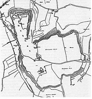
Ham Hill is the site of a huge Bronze Age and Iron Age hill fort. This fort belonged to the Durotriges tribe and dates back to the 1st century BC. Its walls stretch for about 3 miles (5 km) and enclose an area of 210 acres (85 hectares). Most of the fort's edge has a double bank and ditch, making it a "multivallate" hill fort.
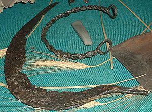
There are two main entrances. One is to the south-east, where the modern road is now. The other is to the north-east, following a path from the Church of St Mary the Virgin in Stoke-sub-Hamdon. Archaeologists have found many interesting items here. These include bronze objects, parts of chariots, iron currency bars, gold and silver coins, and evidence of cremations and burials.
Romans at Ham Hill
Around AD 45, the Roman Second Legion (Augusta) captured Ham Hill. This legion was led by Vespasian, who later became an emperor. They had already taken other hill forts to the south, like Maiden Castle. Many Roman military items have been found here. It's likely the Second Legion set up a temporary camp on the hill, similar to what they did at Hod Hill.
After these early battles, a more permanent Roman camp was built nearby in Ilchester. The Fosse Way, an important Roman military road, was built within 1 mile (1.6 km) of Ham Hill. This road went towards Axminster and the Roman base at Exeter.
The area around Ham Hill was very rich during the Roman period. Several large Roman villas (country houses) have been found nearby. One was on the eastern part of the hill in a field called "Warren," with a large mosaic floor. Other villas were found at Stoke-sub-Hamdon, Odcombe, Lufton, and West Coker. Just east of the main hill is St. Michael's Hill. This "pointed hill" gave its name to the village of Montacute. The Normans later built a motte-and-bailey castle there.
South of the main hill, you can see "strip lynchets." These are low terraces created by ancient farming and ploughing. There's also the deserted medieval village of Witcombe (or Whitcombe) nearby. This village was finally abandoned in the 17th century.
Quarrying History
In the 1800s, there were 24 small quarry operations on Ham Hill, employing about 200 men. This continued into the Victorian era, with over 200 small family-run quarries and stone businesses. Many of these smaller quarries stopped working by 1910.
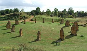
Today, hamstone is only quarried in two areas at the top of Ham Hill. The North quarry, near the modern stone circle and war memorial, has been operating the longest. The southern, Norton Quarry, gets its stone from about 20–30 metres below the surface. This quarry is run by Harvey Stone. It reopened about 15 years ago, after being closed in the 1930s because people thought there was "no good quality stone left." Both quarries are owned by the Duchy of Cornwall.
War Memorial
The northern end of Ham Hill has a war memorial. It honours the people from the nearby village of Stoke-sub-Hamdon who died in the two World Wars and later conflicts. The memorial was designed in 1920 and unveiled in 1923. It has four steps leading to a square base and a tall, four-sided obelisk with a flat top.
The memorial is easy to see from the surrounding countryside, including the A303 road, which follows the old Fosse Way near the base of the hill. Just below the Monument, there is a bench dedicated to the memory of a local student.
Fun Activities at Ham Hill
Ham Hill and its country park offer many fun things to do. You can go walking, horse riding, or mountain biking. It's also a popular spot for orienteering and dog walkers. Ham Hill is the end point of the Leland trail, a 28-mile (45 km) footpath that starts at King Alfred's Tower.
For those who like climbing, Ham Hill has about 20 climbing routes. These are mostly "top roped" routes because of the type of rock and to protect the geological features. There are also several bouldering problems.
You can try two compass trails for orienteering: one in the stone circle area and another in Witcombe Valley. These trails have letters from A to J marked on small squares attached to posts, signs, gates, and rocks.
Ham Hill is also close to the Monarch's Way, a 615-mile (990 km) long-distance footpath. This path follows the escape route taken by King Charles II in 1651 after he lost the Battle of Worcester. It's also the start of the Liberty Trail, which covers 28 miles (45 km) to Lyme Regis in Dorset.
Ham Hill Country Park
Ham Hill is managed as a 390-acre (158 hectare) country park by South Somerset District Council. Over 250,000 people visit it every year.
Before Ham Hill became a country park, three local farms used to let their animals graze freely on the main grassy area. When it became a country park, more visitors came, and especially more dogs. The dogs made it impossible to graze sheep. This has changed the plants growing there over the last forty years.
Areas that used to have short grass with small plants like wild thyme and clover are now covered in tall bracken, gorse, bramble, and wild parsley. Without sheep grazing, woodland has also grown and covered the old Iron Age earthworks, especially on the north side of the hill.
A big fire on the south-west side of the hill in the dry summer of 1976 destroyed all the plants there. When new plants grew back, bracken was the main one. In some places, this has now turned into woodland, but the nice grassland from before the fire has not returned.
Farming practices have also caused changes. In the past, the flat fields on top of the hill were mostly used for grazing animals or growing spring wheat. They were left empty in winter. Sometimes, the fields were lightly ploughed, and mangold plants were grown for winter animal food.
In the 1980s, the ownership changed, and farmers started planting grain in winter with deep ploughing. This immediately changed the wildlife. Winter flocks of finches disappeared, yellowhammers vanished, and skylarks almost did too. The deep ploughing also brought millions of poppy seeds to the surface, making it hard to harvest the grain. This was something an older farmer had warned about years before. It was around this time that deep ploughing likely damaged the remains of a Roman mosaic at Batemore. The site was ploughed over, and small pieces of tile came to the surface.
Now, the park authorities control the plateau fields. They are trying to restore them by letting natural grassland grow back, with controlled sheep grazing.
 | Isaac Myers |
 | D. Hamilton Jackson |
 | A. Philip Randolph |


