Texarkana, Texas facts for kids
Quick facts for kids
Texarkana, Texas
|
|
|---|---|

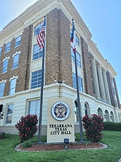
Texarkana Texas City Hall
|
|
| Nickname(s):
The Texas Side, T-Town, TK, Kana, Twin City
|
|
| Motto(s):
Twice as Nice
|
|

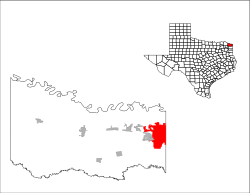
Location of Texarkana, Texas
|
|
| Country | United States |
| State | Texas |
| County | Bowie |
| Government | |
| • Type | Council-Manager |
| Area | |
| • Total | 29.47 sq mi (76.33 km2) |
| • Land | 29.03 sq mi (75.20 km2) |
| • Water | 0.44 sq mi (1.13 km2) |
| Elevation | 325 ft (99 m) |
| Population
(2020)
|
|
| • Total | 36,193 |
| • Density | 1,228.13/sq mi (474.16/km2) |
| Time zone | UTC−6 (Central (CST)) |
| • Summer (DST) | UTC−5 (CDT) |
| ZIP codes |
755XX.
|
| Area codes | 903, 430 |
| FIPS code | 48-72368 |
| GNIS feature ID | 2412054 |
Texarkana is a city in Bowie County, Texas, located in a special area called Ark-La-Tex. This region gets its name because it's where Arkansas, Louisiana, and Texas meet! Texarkana, Texas, is like a twin city to Texarkana, Arkansas, right next door.
The Texas city is about 180 miles (290 km) from Dallas. In 2020, about 36,193 people lived in Texarkana, Texas. Both Texarkana cities together form the main part of the Texarkana metropolitan area. This area includes all of Bowie County in Texas and Miller County, Arkansas. In 2020, the two cities had a combined population of 65,580 people. The entire metropolitan area had about 149,482 residents.
Contents
History of Texarkana
Railroads were very important for connecting different places. In the late 1850s, the Cairo and Fulton Railroad was building its tracks south through Arkansas. By 1874, their line reached the Texas state border.
Trains started running between the Texas border and the Red River in early 1874. Passengers and goods then used a ferry to cross the river to Fulton, Arkansas. From there, they could continue their journey by train. The Red River Bridge opened on March 20, 1874. After this, trains could travel directly from Texarkana to St. Louis, Missouri.
There was a big competition between railroad builders in the 1870s. The Texas and Pacific Railroad was building its line across Texas to the Arkansas state line. The border was the perfect spot for these different railway lines to connect. On December 8, 1873, the Texas and Pacific company sold the very first pieces of land for the new city. The first person to buy land was J. W. Davis. He bought the spot where the Hotel McCartney now stands on the Texas side. This was right across from Union Station, which is built right on the border between Texas and Arkansas.
What Does the Name Texarkana Mean?
The name Texarkana is a portmanteau. This means it's a word made by blending parts of other words. Texarkana comes from Texas, Arkansas, and nearby Louisiana.
However, there are different stories about how the name first appeared. It was used even before the city was officially founded.
- The most popular story says that a railroad surveyor named Col. Gus Knobel made up the name. He was working for the St. Louis, Iron Mountain and Southern Railway. He supposedly painted the name on a wooden plank and nailed it to a tree. He said, "This is the name of a town which is to be built here."
- Another story suggests the name came from a steamboat called The Texarkana, around 1860. This boat traveled on the Red River.
- A third story tells of a store owner named Swindle in Red Land, Louisiana. He made a drink called "Texarkana Bitters."
Geography and Location
Texarkana is located in the very northeast corner of Texas. It sits right where Interstate 30 meets several US highways, including 59, 67, 71, and 82.
The city of Texarkana, Arkansas, is right next to it on the east. To the west, you'll find smaller Texas cities like Nash, Wake Village, and Liberty Eylau. Texarkana is in the Central Time Zone.
The Texas city covers a total area of about 29.47 square miles (76.3 square kilometers). Most of this is land, with a small part (about 1.39%) covered by water. The city is roughly 180 miles (290 km) northeast of Dallas.
Several creeks flow through the area. These include Wagner Creek, Cowhorn Creek, Swampoodle Creek, and Days Creek.
Texarkana's Climate
Texarkana has a humid subtropical climate (Cfa). This means it has hot, humid summers and mild winters.
- The hottest month is usually August.
- The highest temperature ever recorded was 117 °F (47 °C) in 1936.
- January is typically the coolest month.
- The lowest temperature ever recorded was –6 °F (–21 °C) in December 1989.
- December usually gets the most rain.
| Climate data for Texarkana, Texas (1991–2020 normals, extremes 1968–present) | |||||||||||||
|---|---|---|---|---|---|---|---|---|---|---|---|---|---|
| Month | Jan | Feb | Mar | Apr | May | Jun | Jul | Aug | Sep | Oct | Nov | Dec | Year |
| Record high °F (°C) | 81 (27) |
89 (32) |
89 (32) |
95 (35) |
98 (37) |
105 (41) |
105 (41) |
112 (44) |
108 (42) |
95 (35) |
87 (31) |
83 (28) |
112 (44) |
| Mean maximum °F (°C) | 73.3 (22.9) |
76.9 (24.9) |
83.6 (28.7) |
86.9 (30.5) |
91.1 (32.8) |
95.8 (35.4) |
99.9 (37.7) |
100.8 (38.2) |
97.2 (36.2) |
89.7 (32.1) |
80.1 (26.7) |
74.8 (23.8) |
102.0 (38.9) |
| Mean daily maximum °F (°C) | 54.3 (12.4) |
58.6 (14.8) |
66.7 (19.3) |
74.8 (23.8) |
82.0 (27.8) |
89.3 (31.8) |
93.3 (34.1) |
93.5 (34.2) |
87.2 (30.7) |
76.7 (24.8) |
64.8 (18.2) |
56.3 (13.5) |
74.8 (23.8) |
| Daily mean °F (°C) | 43.7 (6.5) |
47.6 (8.7) |
55.2 (12.9) |
63.1 (17.3) |
71.8 (22.1) |
79.6 (26.4) |
83.2 (28.4) |
82.8 (28.2) |
76.2 (24.6) |
64.9 (18.3) |
53.6 (12.0) |
46.1 (7.8) |
64.0 (17.8) |
| Mean daily minimum °F (°C) | 33.1 (0.6) |
36.6 (2.6) |
43.8 (6.6) |
51.4 (10.8) |
61.7 (16.5) |
69.8 (21.0) |
73.0 (22.8) |
72.1 (22.3) |
65.2 (18.4) |
53.2 (11.8) |
42.4 (5.8) |
35.8 (2.1) |
53.2 (11.8) |
| Mean minimum °F (°C) | 19.8 (−6.8) |
24.9 (−3.9) |
29.2 (−1.6) |
37.7 (3.2) |
48.7 (9.3) |
61.8 (16.6) |
67.3 (19.6) |
65.8 (18.8) |
53.4 (11.9) |
38.9 (3.8) |
28.8 (−1.8) |
23.9 (−4.5) |
17.9 (−7.8) |
| Record low °F (°C) | 2 (−17) |
−3 (−19) |
15 (−9) |
28 (−2) |
38 (3) |
52 (11) |
57 (14) |
55 (13) |
38 (3) |
27 (−3) |
16 (−9) |
−6 (−21) |
−6 (−21) |
| Average precipitation inches (mm) | 4.26 (108) |
4.58 (116) |
4.70 (119) |
4.88 (124) |
5.25 (133) |
4.39 (112) |
3.40 (86) |
2.77 (70) |
3.89 (99) |
4.78 (121) |
4.33 (110) |
5.18 (132) |
52.41 (1,331) |
| Average snowfall inches (cm) | 1.0 (2.5) |
1.0 (2.5) |
0.0 (0.0) |
0.0 (0.0) |
0.0 (0.0) |
0.0 (0.0) |
0.0 (0.0) |
0.0 (0.0) |
0.0 (0.0) |
0.0 (0.0) |
0.0 (0.0) |
0.1 (0.25) |
2.1 (5.3) |
| Average precipitation days (≥ 0.01 in) | 11.0 | 11.2 | 10.8 | 9.7 | 10.3 | 8.5 | 6.8 | 6.5 | 6.7 | 8.6 | 9.1 | 10.6 | 109.8 |
| Average snowy days (≥ 0.1 in) | 0.3 | 0.4 | 0.0 | 0.0 | 0.0 | 0.0 | 0.0 | 0.0 | 0.0 | 0.0 | 0.0 | 0.1 | 0.8 |
| Source: NOAA | |||||||||||||
On May 22, 2008, a strong wind event called a microburst hit the area. Winds reached up to 100 mph (160 km/h). This happened when two severe thunderstorms crashed into each other south of downtown Texarkana.
On May 16, 2020, a waterspout tornado formed over nearby Lake Wright Patman.
A very unusual weather event happened on December 31, 2021. Fish fell from the sky and landed in people's yards and on sidewalks! This rare phenomenon is sometimes called "animal rain."
People of Texarkana
| Historical population | |||
|---|---|---|---|
| Census | Pop. | %± | |
| 1880 | 1,833 | — | |
| 1890 | 2,852 | 55.6% | |
| 1900 | 5,256 | 84.3% | |
| 1910 | 9,790 | 86.3% | |
| 1920 | 11,480 | 17.3% | |
| 1930 | 16,602 | 44.6% | |
| 1940 | 17,019 | 2.5% | |
| 1950 | 24,753 | 45.4% | |
| 1960 | 30,218 | 22.1% | |
| 1970 | 30,497 | 0.9% | |
| 1980 | 31,271 | 2.5% | |
| 1990 | 31,656 | 1.2% | |
| 2000 | 34,782 | 9.9% | |
| 2010 | 36,411 | 4.7% | |
| 2020 | 36,193 | −0.6% | |
| U.S. Decennial Census 1850–1900 1910 1920 1930 1940 1950 1960 1970 1980 1990 2000 2010 |
|||
In 2020, the city had 36,193 people living there. There were 14,148 households and 8,767 families. The population density was about 1,228 people per square mile (474 per square kilometer).
Here's a look at the different groups of people living in Texarkana in 2020:
| Group | Number of People | Percentage |
|---|---|---|
| White (not Hispanic) | 16,825 | 46.49% |
| Black or African American (not Hispanic) | 13,565 | 37.48% |
| Native American or Alaska Native (not Hispanic) | 164 | 0.45% |
| Asian (not Hispanic) | 736 | 2.03% |
| Pacific Islander (not Hispanic) | 25 | 0.07% |
| Other Race (not Hispanic) | 173 | 0.48% |
| Mixed/Multi-Racial (not Hispanic) | 1,613 | 4.46% |
| Hispanic or Latino | 3,092 | 8.54% |
| Total | 36,193 |
About 26% of the population was under 18 years old. The average age in the city was 36 years. For every 100 females, there were about 89 males.
The average income for a household in the city was about $29,727. For families, it was about $39,119. About 24% of the population lived below the poverty line. This included 34.8% of those under 18 and 13.2% of those 65 or older.
Texarkana's Economy
Texarkana has many important employers. Here are the top employers in the Texarkana area as of 2021:
| # | Employer | Number of Employees |
|---|---|---|
| 1 | Red River Army Depot and related businesses | 2,225 |
| 2 | Christus St. Michael Health Care | 1,800 |
| 3 | Cooper Tire & Rubber Company | 1,793 |
| 4 | Wal-Mart/Sam's Club | 875 |
| 5 | Texarkana Independent School District | 846 |
| 6 | Graphic Packaging (International Paper) | 829 |
| 7 | Wadley Regional Medical Center | 652 |
| 8 | Domtar | 548 |
| 9 | Texarkana Arkansas School District | 370 |
| 10 | City of Texarkana, Texas | 365 |
Education in Texarkana
Public Schools
Schools in Texarkana, Texas, are managed by several different school districts:
- Texarkana Independent School District
- Liberty-Eylau Independent School District
- Pleasant Grove Independent School District
- Red Lick Independent School District
Colleges and Universities
Texarkana is home to two higher education institutions:
- Texas A&M University–Texarkana: This is a four-year university that is part of the Texas A&M University System.
- Texarkana College: This is a community college that offers two-year programs.
Media in Texarkana
Television
Texarkana is part of the Shreveport-Texarkana media market. This is the 89th largest media market in the United States.
- KTAL-TV 6 is the NBC channel for the area.
- Other channels include KTBS-TV 3 (ABC), KSLA 12 (CBS), KTSH-CD 19 (Telemundo), KPXJ 21 (CW), KMSS-TV 33 (Fox), KSHV-TV 45 (MyNetworkTV), and two PBS stations: KETG 9 and KLTS-TV 24.
Radio
Texarkana has 4 AM radio stations and 19 FM stations. Most stations are owned locally. However, Townsquare Media also owns several stations in the area.
Transportation in Texarkana

- Texarkana Regional Airport is located in Texarkana, Arkansas. It serves smaller planes and offers American Eagle flights to Dallas/Fort Worth International Airport.
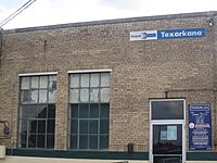
- Texarkana Union Station is in downtown Texarkana, right on the state line. Amtrak's Texas Eagle train stops here daily. It travels east to Chicago and west to San Antonio. Three days a week, it continues all the way to Los Angeles.
- The Texarkana Urban Transit District provides bus service around the city. There are nine different bus routes. Buses run from 5:30 am to 6:20 pm, Monday through Saturday.
- Jefferson Lines provides bus service between cities.
- Interstate 30 runs through the north side of Texarkana.
- Loop 151 is on the west side of the city. It's part of the Texarkana Loop, which goes around the west, south, and east parts of both Texarkana cities. I-30 completes the loop on the north.
- Interstate 369 shares the western part of Loop 151.
- Interstate 49 is a newer highway on the Arkansas side of the city. It connects Texarkana to Shreveport, Louisiana.
Famous People from Texarkana
- McTelvin Agim, NFL defensive end
- Joe Anderson, NFL wide receiver
- Miller Barber, former PGA Tour golfer
- Jesse Belvin, singer, pianist, and songwriter
- Footsie Blair, (1900–1982) - was a Major League Baseball second baseman for the Chicago Cubs.
- J.B. Bobo, magician
- Ben M. Bogard, clergyman, founder of American Baptist Association in Texarkana in 1924
- Willie Buchanon, former NFL football player
- Melvin Bunch, former MLB baseball player
- David Crowder, musician
- James C. Dodd, architect
- Robert Ealey, electric blues singer
- Carl Finch, musician, founder of Brave Combo
- Corinne Griffith, silent-film actress
- Harmonica Slim, blues harmonicist, singer, and songwriter
- Rich Houston, former New York Giants NFL football player
- V. E. Howard, clergyman who founded the International Gospel Hour
- LaMichael James, football player for the San Francisco 49ers and Miami Dolphins
- Brandon Jones, NFL wide receiver
- Parnelli Jones, race car driver in International Motorsports Hall of Fame
- Scott Joplin, ragtime music composer and pianist
- Jeff Keith, lead singer of rock band Tesla
- Jarrion Lawson, American sprinter and long jumper
- Joshua Logan, film and stage director, Tony Award and Pulitzer Prize winner
- Ryan Mallett, NFL quarterback for Baltimore Ravens
- Eddie Mathews, baseball player in Hall of Fame
- Will Middlebrooks, baseball player for the Milwaukee Brewers
- Craig Monroe, baseball player
- Mac Morgan, opera singer
- Dustin Moseley, baseball player
- Ross Perot, businessman and politician
- Charles B. Pierce, movie producer
- Molly Quinn, actress
- John D. Raffaelli, American lobbyist
- James Theodore Richmond, writer, conservationist
- Joscelyn Roberson, USA artistic gymnast
- Bill Rogers, golfer
- Dame Marjorie Morris Scardino, Pulitzer Prize-winning publisher and CEO of Pearson PLC
- Michael Jarboe Sheehan, Roman Catholic Archbishop of Santa Fe
- Rod Smith, NFL player for Denver Broncos
- Drew Stubbs, baseball player for the Cincinnati Reds and Colorado Rockies
- Marshall Terrill, author
- Aysel Teymurzadeh, singer, performer
- Michael Trimble, opera singer, voice teacher
- Nathan Vasher, football player
- Michael Wacha, baseball player for the San Diego Padres
- Frank D. White, governor of Arkansas from 1981 to 1983
- Otis Williams, musician, founding member of The Temptations
See also
 In Spanish: Texarkana (Texas) para niños


