Truro, Massachusetts facts for kids
Quick facts for kids
Truro, Massachusetts
|
|||
|---|---|---|---|
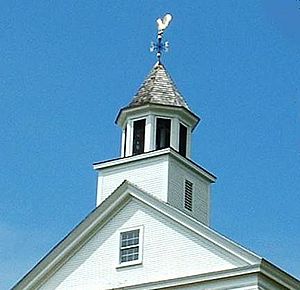
Truro Town Hall
|
|||
|
|||
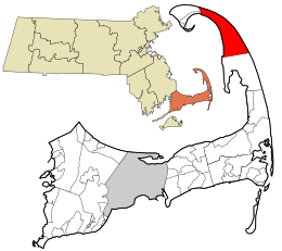
Location in Barnstable County and the Commonwealth of Massachusetts.
|
|||
| Country | United States | ||
| State | Massachusetts | ||
| County | Barnstable | ||
| Settled | 1700 | ||
| Incorporated | 1709 | ||
| Government | |||
| • Type | Open town meeting | ||
| Area | |||
| • Total | 26.3 sq mi (68.2 km2) | ||
| • Land | 21.1 sq mi (54.5 km2) | ||
| • Water | 5.3 sq mi (13.6 km2) | ||
| Elevation | 25 ft (8 m) | ||
| Population
(2020)
|
|||
| • Total | 2,454 | ||
| • Density | 116.3/sq mi (45.0/km2) | ||
| Time zone | UTC-5 (Eastern) | ||
| • Summer (DST) | UTC-4 (Eastern) | ||
| ZIP code |
02666
|
||
| Area code(s) | 508 | ||
| FIPS code | 25-70605 | ||
| GNIS feature ID | 0618260 | ||
| Website | truro-ma.gov | ||
Truro is a small town in Barnstable County, Massachusetts. It has two main parts: Truro and North Truro. The town is about 100 miles (160 km) from Boston.
Truro is a popular place for summer vacations. It is located near the very tip of Cape Cod. English settlers named the town after Truro in Cornwall, United Kingdom.
The Wampanoag, who are Native American people, lived here first. They called the area Pamet or Payomet. This name is still used for the Pamet River and the harbor area. In 2020, about 2,454 people lived in Truro.
More than half of Truro's land is part of the Cape Cod National Seashore. This special area was created in 1961 by President John F. Kennedy. The U.S. National Park Service takes care of it.
Contents
Truro's Story: A Look Back in Time
Long before Europeans arrived, indigenous peoples lived on Cape Cod for thousands of years. When English settlers came, the Wampanoag tribe was the main group on Cape Cod. There were about 7,000 Wampanoag people at that time.
They used the land and water for hunting, fishing, and gathering shellfish. They also grew maize (corn) to eat and store for winter.
The English Pilgrims first stopped in Truro and Provincetown in 1620. They were looking for a place to settle. They found fresh water and corn stored by the Wampanoag. This place became known as Corn Hill.
English immigrant colonists began settling in Truro in the 1690s. It was the northern part of the town of Eastham back then. Truro officially became its own town in 1709.
Early industries in Truro included fishing, whaling, and shipbuilding. However, strong ocean tides changed the town's main port in the 1850s. This made these industries move to other places. In the late 1800s and early 1900s, many artists came to Cape Cod. They loved the special light here.
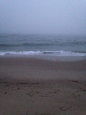
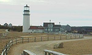
Today, Truro is known for its beautiful homes and rolling hills. It has sand dunes along the coast. Truro is also home to the Highland Light, also called the Cape Cod Light. This is the oldest lighthouse on Cape Cod. The first lighthouse was built in 1797. The one you see today was built in 1857. In 1996, the entire 430-ton lighthouse was moved. It was moved about 1⁄10 of a mile (160 meters) inland because the cliffs were eroding.
Where Truro Is Located
Truro covers about 26.3 square miles (68.2 km2). About 21.0 square miles (54.5 km2) is land, and 5.3 square miles (13.6 km2) is water.
Truro is located just south and east of the "tip" of Cape Cod. It shares a border with Provincetown to the northwest. The Atlantic Ocean is to its north and east. Wellfleet is to the south, and Cape Cod Bay is to the west.
The town is about 38 miles (61 km) from Barnstable. It is 105 miles (169 km) from Boston.
The land in Truro generally slopes down from the Atlantic Ocean side to the Cape Cod Bay side. It also slopes from south to north. There are several small ponds in town. Pilgrim Lake is just east of the Provincetown town line. It is south of the sand dunes that make up most of the northern tip of the Cape.
Pamet Harbor is a small inlet on the Cape Cod Bay side. It leads to the Pamet River. Near the lighthouse, there is a Coast Guard radar station. It has a Doppler radar tower. This is close to the Jenny Lind Tower.
Weather in Truro
Truro has a mild summer Humid continental climate. This means it has warm summers and cold, snowy winters. The average yearly snowfall is about 30 inches (76 cm). February usually gets the most snow.
| Climate data for Truro, Barnstable County, Massachusetts (1981–2010 averages). | |||||||||||||
|---|---|---|---|---|---|---|---|---|---|---|---|---|---|
| Month | Jan | Feb | Mar | Apr | May | Jun | Jul | Aug | Sep | Oct | Nov | Dec | Year |
| Mean daily maximum °F (°C) | 38.5 (3.6) |
39.6 (4.2) |
44.7 (7.1) |
53.7 (12.1) |
62.9 (17.2) |
73.4 (23.0) |
79.4 (26.3) |
78.0 (25.6) |
71.5 (21.9) |
61.9 (16.6) |
53.0 (11.7) |
44.4 (6.9) |
58.5 (14.7) |
| Daily mean °F (°C) | 31.8 (−0.1) |
32.9 (0.5) |
37.9 (3.3) |
46.5 (8.1) |
55.3 (12.9) |
65.2 (18.4) |
71.4 (21.9) |
70.6 (21.4) |
64.3 (17.9) |
54.7 (12.6) |
46.2 (7.9) |
37.4 (3.0) |
51.3 (10.7) |
| Mean daily minimum °F (°C) | 25.1 (−3.8) |
26.2 (−3.2) |
31.0 (−0.6) |
39.2 (4.0) |
47.8 (8.8) |
56.9 (13.8) |
63.4 (17.4) |
63.2 (17.3) |
57.0 (13.9) |
47.5 (8.6) |
39.4 (4.1) |
30.3 (−0.9) |
44.0 (6.7) |
| Average precipitation inches (mm) | 3.73 (95) |
3.23 (82) |
4.35 (110) |
4.21 (107) |
3.32 (84) |
3.54 (90) |
2.86 (73) |
3.68 (93) |
3.59 (91) |
4.09 (104) |
4.36 (111) |
3.87 (98) |
44.83 (1,139) |
| Average relative humidity (%) | 68.2 | 66.9 | 66.7 | 67.7 | 70.3 | 71.6 | 73.8 | 74.2 | 74.4 | 70.0 | 67.9 | 66.6 | 69.9 |
| Source: PRISM Climate Group | |||||||||||||
| Month | Jan | Feb | Mar | Apr | May | Jun | Jul | Aug | Sep | Oct | Nov | Dec | Year |
|---|---|---|---|---|---|---|---|---|---|---|---|---|---|
| Average Dew Point °F | 22.5 | 23.1 | 27.8 | 36.4 | 45.8 | 55.8 | 62.6 | 62.0 | 56.0 | 45.1 | 36.2 | 27.3 | 41.8 |
| Average Dew Point °C | −5.3 | −4.9 | −2.3 | 2.4 | 7.7 | 13.2 | 17.0 | 16.7 | 13.3 | 7.3 | 2.3 | −2.6 | 5.4 |
|
Source = PRISM Climate Group
|
|||||||||||||
People of Truro
| Historical population | ||
|---|---|---|
| Year | Pop. | ±% |
| 1850 | 2,051 | — |
| 1860 | 1,583 | −22.8% |
| 1870 | 1,269 | −19.8% |
| 1880 | 1,017 | −19.9% |
| 1890 | 919 | −9.6% |
| 1900 | 767 | −16.5% |
| 1910 | 655 | −14.6% |
| 1920 | 554 | −15.4% |
| 1930 | 513 | −7.4% |
| 1940 | 585 | +14.0% |
| 1950 | 661 | +13.0% |
| 1960 | 1,002 | +51.6% |
| 1970 | 1,234 | +23.2% |
| 1980 | 1,486 | +20.4% |
| 1990 | 1,573 | +5.9% |
| 2000 | 2,087 | +32.7% |
| 2010 | 2,003 | −4.0% |
| 2020 | 2,454 | +22.5% |
| 2023* | 2,479 | +1.0% |
| * = population estimate. Source: United States Census records and Population Estimates Program data. |
||
In 2000, there were 2,087 people living in Truro. There were 907 households and 515 families. The population density was about 99 people per square mile (38 per km2).
Most people in Truro were White (95.11%). There were also small numbers of African American, Native American, Asian, and Pacific Islander residents. Some people identified as being from other races or from two or more races. About 1.15% of the population was Hispanic or Latino.
About 21.2% of households had children under 18. Nearly half (46.3%) were married couples. About 12.5% of households had someone aged 65 or older living alone. The average household had 2.18 people.
The median age in Truro was 46 years old. This means half the people were older than 46 and half were younger. About 17.4% of the population was under 18. About 17.0% were 65 or older.
The median income for a household was $42,981. For a family, it was $51,389. The average income per person was $22,608. About 11.2% of the population lived below the poverty line. This included 8.5% of those under 18.
Learning in Truro
Truro has the Truro Central School for students from pre-kindergarten through eighth grade. Truro does not have its own high school. Students go to Nauset Regional High School through a special agreement. Usually, students above grade 6 go to Nauset schools.
There are no private high schools on the lower Cape. High school students can also choose to attend the Cape Cod Regional Technical High School in Harwich. They can also go to Monomoy Regional High School in Harwich, or Sturgis Charter School in Hyannis.
There are special scholarships for students from Truro and Provincetown. These are the John Anderson Francis Family Scholarship Fund and the Captain Joseph F. Oliver Scholarship Fund.
The Truro Public Library is a busy place in the community. It often has puppet shows. Outside the library, there is a pavilion. Many parents see the library as a "home away from home."
Getting Around Truro
U.S. Route 6 (US 6) is the main road through Truro. It runs from south to north towards Provincetown. Massachusetts Route 6A (Route 6A) also starts in Truro. It follows the old path of US 6.
There are no train services or airports directly in Truro. The closest small airport is in nearby Provincetown. For bigger flights, the nearest major airport is Logan International Airport in Boston.
Famous People from Truro
- Marshall Ayres, a pioneer in the American west
- Edward Knight Collins, a shipping leader from the 1800s
- Lee Falk, a writer
- L. Thomas Hopkins, an education expert
- Edward Hopper, a famous artist
- Patty Larkin, a singer-songwriter
- Lucy L'Engle, an artist
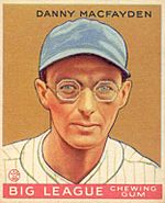
- Danny MacFayden, a Major League Baseball pitcher
- Nick Minnerath, a professional basketball player
- Steve Nelson, a political activist
- Anthony Perkins, an American actor
- Josh Taves, an American football player
Shipwrecks Near Truro
Off Head of the Meadow beach in Truro, you can sometimes see the remains of a shipwreck. This is the Frances, a three-masted barque (a type of sailing ship). The ship was from Hamburg, Germany. It wrecked off Truro on December 27, 1872. It was on its way from the Far East to Boston. The wreck is usually underwater, but it can be seen when the weather and tides are just right.
Images for kids
See also
 In Spanish: Truro (Massachusetts) para niños
 | Anna J. Cooper |
 | Mary McLeod Bethune |
 | Lillie Mae Bradford |


