Tuscola County, Michigan facts for kids
Quick facts for kids
Tuscola County
|
|
|---|---|

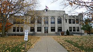
Tuscola County Courthouse in Caro
|
|

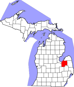
Location within the U.S. state of Michigan
|
|
 Michigan's location within the U.S. |
|
| Country | |
| State | |
| Founded | April 1, 1840 organized March 2, 1850 |
| Seat | Caro |
| Largest city | Caro |
| Area | |
| • Total | 914 sq mi (2,370 km2) |
| • Land | 803 sq mi (2,080 km2) |
| • Water | 111 sq mi (290 km2) 12% |
| Population
(2020)
|
|
| • Total | 53,323 |
| • Density | 66/sq mi (25/km2) |
| Time zone | UTC−5 (Eastern) |
| • Summer (DST) | UTC−4 (EDT) |
| Congressional districts | 8th, 9th |
Tuscola County (pronounced TUSS-koh-lə) is a county located in the "Thumb" region of the U.S. state of Michigan. If you look at a map of Michigan, this area looks like a thumb sticking out!
As of the 2020 census, about 53,323 people lived in Tuscola County. The main town, or county seat, is Caro. The county was officially created by Michigan law on April 1, 1840. People living there were allowed to set up their own government on March 2, 1850.
Tuscola County is one of five counties in the Thumb area. Just like the rest of the Thumb, Tuscola County is a popular place for tourists. Many visitors come from cities like Flint, Detroit, and Saginaw to enjoy the area.
Contents
History of Tuscola County
What's in a Name? The Story of "Tuscola"
The name "Tuscola" was made up by a man named Henry Schoolcraft. He often created names using parts of Native American words. For "Tuscola," he likely used an Ojibwe word, "desakamigaa," which means "flat level ground" or "flat country."
For the ending, Mr. Schoolcraft used a part of the Latin word "colo," which means "to cultivate," "till," or "farm." So, "Tuscola" can mean "the flat cultivated land." Henry Schoolcraft himself once said that Tuscola came from Native words and meant "level lands."
The Thumb Region's Old Names
In the 1600s, the Thumb region of Michigan was called "Skenchioe" by the Iroquois-speaking people. This name might be related to an Onondaga word meaning "a large, open plain."
Later, in the early 1700s, the French called this area "Le Pays Plat," which means "The Flat Country." The English also called it the "Flat Country" in the late 1700s.
Even though it's called "Flat Country," the Thumb of Michigan actually has some small hills, or "knolls," especially in the middle part along the Cass River. Caro, the county seat of Tuscola, is located north of the Cass River on one of these larger knolls. The land around Caro is very flat and used a lot for farming. The township where Caro is located is called Indianfields because it used to have many Native American gardens.
Treaties and Land Sales
In 1819, a special agreement called the Treaty of Saginaw was made. A Native American leader named Chief Otusson represented the Cass River and Tuscola area. Chief Otusson's Reservation was located where the town of Frankenmuth, Michigan, is today. This reservation, along with a lot of the land around it, was sold in another treaty in 1837.
Geography of Tuscola County
According to the U.S. Census Bureau, Tuscola County covers a total area of 914 square miles. Most of this, 803 square miles, is land. The remaining 111 square miles (about 12%) is water.
Neighboring Counties
Tuscola County shares its borders with several other counties:
- Huron County (to the north)
- Sanilac County (to the east)
- Saginaw County (to the west)
- Lapeer County (to the southeast)
- Genesee County (to the southwest)
- Bay County (to the west)
Main Roads
Several important highways run through Tuscola County, helping people travel around:
 M-15 (runs north and south)
 M-24 (runs north and south)
 M-25 (runs north and south)
 M-46 (runs east and west)
 M-81 (runs east and west)
- M-138 (runs east and west)
Airport
- Tuscola Area Airport
Population of Tuscola County
| Historical population | |||
|---|---|---|---|
| Census | Pop. | %± | |
| 1850 | 291 | — | |
| 1860 | 4,886 | 1,579.0% | |
| 1870 | 13,714 | 180.7% | |
| 1880 | 25,738 | 87.7% | |
| 1890 | 32,508 | 26.3% | |
| 1900 | 25,890 | −20.4% | |
| 1910 | 34,913 | 34.9% | |
| 1920 | 33,320 | −4.6% | |
| 1930 | 32,934 | −1.2% | |
| 1940 | 35,694 | 8.4% | |
| 1950 | 38,258 | 7.2% | |
| 1960 | 43,305 | 13.2% | |
| 1970 | 48,603 | 12.2% | |
| 1980 | 56,961 | 17.2% | |
| 1990 | 55,498 | −2.6% | |
| 2000 | 58,266 | 5.0% | |
| 2010 | 55,729 | −4.4% | |
| 2020 | 53,323 | −4.3% | |
| 2023 (est.) | 52,826 | −5.2% | |
| U.S. Decennial Census 1790-1960 1900-1990 1990-2000 2010-2018 |
|||
The 2010 United States Census showed that Tuscola County had a population of 55,729 people. This was a small decrease from the year 2000. In 2010, there were 21,590 households and 15,423 families living in the county.
About 96.1% of the people were White, 1.1% Black or African American, and 0.5% Native American. About 2.8% of the population was of Hispanic or Latino background. Many people in the county have German, English, Polish, or Irish family roots.
In terms of age, about 23.5% of the population was under 18 years old. The average age in the county was 42 years.
Religion
The main Catholic Church organization in the region is the Roman Catholic Diocese of Saginaw.
Towns and Villages in Tuscola County
Cities
Villages
Census-designated place
Other Communities
These are smaller, unincorporated communities in the county:
- Bay Park
- Bach
- Bradleyville
- Colling
- Colwood
- Dayton
- Deford
- Denmark Junction
- East Dayton
- Ellington
- Elmwood
- Gilford
- Juniata
- Karrs Corner
- Oakhurst
- Quanicassee
- Richville
- Silverwood
- Thomas
- Tuscola
- Wahjamega
- Watrousville
- Wisner
- Wilmot
Townships
A township is a type of local government area.
- Almer Charter Township
- Akron Township
- Arbela Township
- Columbia Township
- Dayton Township
- Denmark Township
- Elkland Township
- Ellington Township
- Elmwood Township
- Fairgrove Township
- Fremont Township
- Gilford Township
- Indianfields Township
- Juniata Township
- Kingston Township
- Koylton Township
- Millington Township
- Novesta Township
- Tuscola Township
- Vassar Township
- Watertown Township
- Wells Township
- Wisner Township
See also
 In Spanish: Condado de Tuscola para niños
 | James B. Knighten |
 | Azellia White |
 | Willa Brown |

