Typhoon In-fa facts for kids
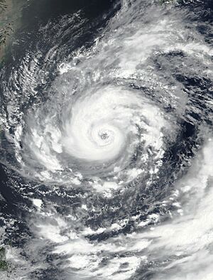
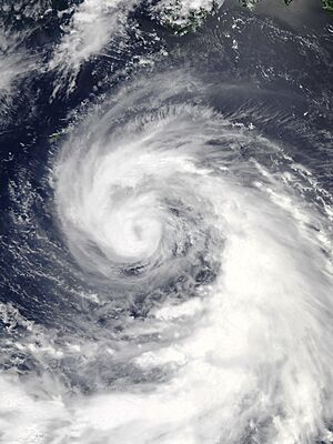
Typhoon In-fa near its peak intensity south of Okinawa on July 21
|
|
| Meteorological history | |
|---|---|
| Formed | July 15, 2021 |
| Extratropical | July 29, 2021 |
| Dissipated | July 31, 2021 |
| Unknown strength tropical cyclone | |
| 10-minute sustained (JMA) | |
| Highest winds | 155 km/h (100 mph) |
| Lowest pressure | 950 hPa (mbar); 28.05 inHg |
| Category 2 typhoon | |
| 1-minute sustained (SSHWS/JTWC) | |
| Highest winds | 175 km/h (110 mph) |
| Lowest pressure | 951 hPa (mbar); 28.08 inHg |
| Overall effects | |
| Fatalities | 6 total |
| Damage | >$1 billion (2021 USD) |
| Areas affected | |
|
Part of the 2021 Pacific typhoon season |
|
Typhoon In-fa, also called Typhoon Fabian in the Philippines, was a huge and expensive tropical cyclone. It caused a record amount of rain in China in July 2021. In fact, it was the second-wettest tropical cyclone ever recorded in China. It was also the first big storm to hit Shanghai since Typhoon Mitag in 2019.
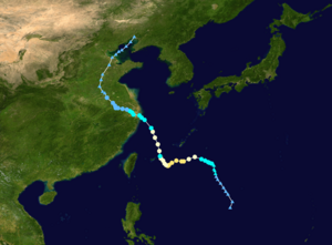
In-fa started as a low-pressure area near the Philippines on July 14. It slowly grew stronger, becoming a tropical depression and then a tropical storm by July 17. The Japan Meteorological Agency (JMA) gave it the name In-fa. The storm moved slowly and struggled to get organized at first. But it kept moving west, getting stronger and becoming a typhoon. On July 21, it reached its strongest point with winds of about 175 km/h (109 mph).
After passing the Ryukyu Islands, In-fa entered the East China Sea. It slowly weakened as it moved towards land. It made landfall twice, first in Zhoushan and then in Pinghu, China, on July 25 and 26. For the next few days, the storm moved slowly inland and got weaker. By July 29, it turned into a leftover low-pressure area over northern China. Its remnants then moved north and disappeared near North Korea on July 31.
Typhoon In-fa caused big waves and heavy rain in the Japanese islands. It damaged many buildings and caused one death there. In the Philippines, heavy rain led to floods and some strong winds, causing five deaths. China faced widespread problems in farming, buildings, and transportation. The typhoon brought huge amounts of rain and storm surges, with some areas getting a month's worth of rain in just a day or two. Rivers overflowed, and floodwaters reached the roofs of cars.
The storm also made the 2021 Henan floods much worse. These floods killed at least 302 people and caused about US$12.7 billion in damage. At least 50 people were also reported missing. The typhoon itself caused at least US$1 billion in damage and six deaths.
Contents
How Typhoon In-fa Formed
Early Days of the Storm
On July 14, weather experts started watching an area of low pressure near Guam. The conditions were good for a storm to form, with warm ocean water and helpful air currents. The next day, they saw a high chance of a tropical cyclone forming.
Early on July 16, the Japan Meteorological Agency (JMA) said the storm was now a depression. A few hours later, the PAGASA in the Philippines named it Tropical Depression Fabian. It was the sixth tropical cyclone in the Philippines that season. The storm moved slowly, first northwest, then north. It looked like a monsoon depression, which is a type of low-pressure system.
Later, some dry air and winds from above made the storm's center less clear. But it slowly kept getting stronger. On July 17, PAGASA called it a tropical storm, and the JMA named it In-fa. The storm continued to move slowly because the winds guiding it were weak.
Growing Stronger
Typhoon In-fa was very large, and dry air kept entering it. This made it hard for the storm to grow quickly, even over warm ocean waters. But as it moved towards the Ryukyu Islands, its rainbands became more organized. A clear "eye" (the calm center of a hurricane) started to appear.
On July 19, the JMA upgraded In-fa to a severe tropical storm. The storm slowed down again as it reached the Ryukyus. Its thunderstorms grew deeper, and the eye became clearer. Six hours later, PAGASA announced that In-fa had become a typhoon. The JMA followed suit a few hours after that. As it passed south of the Daito Islands, a 65 km (40 mi) wide eye was visible on satellite images.
On July 21, In-fa reached its strongest point, with winds of about 175 km/h (109 mph). Radar from Okinawa Island showed a large, clear eye. However, the storm's eyewall (the ring of strong thunderstorms around the eye) was sometimes broken up by dry air.
As In-fa moved west-southwest, its eye became less clear due to more dry air. It also started an "eyewall replacement cycle," where a new eyewall forms around the old one. The storm began to weaken as its eye grew larger and its rainbands became less strong. This was because it was moving over cooler waters and its outflow (air flowing out from the top of the storm) was reduced.
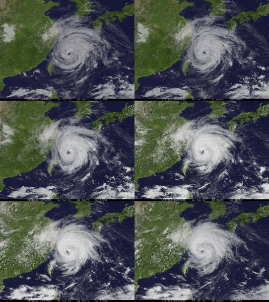
By July 23, In-fa passed between Tarama Island and Miyako-jima Island. Its large eye moved over Miyako-jima. The storm weakened to a tropical storm as it moved away from the Ryukyu Islands and entered the East China Sea. However, it briefly got stronger again on July 24, becoming a low-end typhoon with a ragged eye. PAGASA issued its last update on In-fa that day as it left the Philippine area. The JMA then said In-fa reached its peak strength with winds of about 150 km/h (93 mph) and a minimum pressure of 950 hPa.
Landfalls in China and End of the Storm
In-fa continued to move north-northwest, staying at a low-end typhoon strength. This was because it was moving over cooler waters. On July 25, the storm made its first landfall in Zhejiang province, China, in the Putuo District of Zhoushan.
After landfall, the storm quickly weakened to a tropical storm. Its eye became less clear, and its strong thunderstorms spread out more. Even though it moved inland, In-fa kept its strong winds. On July 26, it made its second landfall near Pinghu, Jiaxing, with winds of about 75 km/h (47 mph). After this, weather experts stopped issuing warnings because it was moving far inland and wouldn't get stronger.
The JMA downgraded In-fa to a tropical storm, then to a tropical depression by July 27. It continued to move west-northwest, then north, and finally northeast. By July 29, the JMA said it was just a low-pressure area. The remnants of In-fa entered the Bohai Sea and then disappeared near North Korea on July 31.
Getting Ready for the Storm
People living near the sea were worried about storm surges (when water levels rise higher than normal) and big waves.
Japan's Preparations
In the Ryukyu Islands, weather officials met on July 17 to talk about the storm. They warned people to be careful. Strong winds and heavy rains were expected. Warnings for waves were issued for islands like Okinawa, Miyako Islands, and Amami Islands. Lightning and wind warnings were also put in place for the Daitō Islands. Later, sea warnings were issued for the East China Sea and coastal areas of Kagoshima Prefecture and Shikoku.
Schools in Kitadaitō, Okinawa closed temporarily, and roads were shut down starting July 19. Fishing boats had to stay in port. Airlines like Japan Airlines and All Nippon Airways canceled many flights across the Ryukyus and mainland Japan, affecting over 16,600 people. About 50 ships were also stopped from traveling. The city of Nanjō even postponed its vaccination activities because of the storm.
Philippines' Preparations
Even though the storm was far from the Philippines, it was expected to make the usual southwest monsoon stronger. This meant heavy rains for Luzon and the Visayas. PAGASA issued heavy rainfall warnings for Metro Manila and nearby provinces. As the typhoon moved closer, PAGASA raised a warning for Batanes and Babuyan to prepare for strong winds and heavy rain.
Taiwan's Preparations
The Central Weather Bureau in Taiwan warned about heavy rain for Kaohsiung, Pingtung County, and the Hengchun Peninsula. They also issued a sea warning for the northern and eastern coasts. Experts warned that Taiwan's mountains could lead to bad floods and landslides from In-fa's rain. Up to 30 to 50 cm (12 to 20 inches) of rain was expected.
On July 22, a heavy rain advisory was issued for northern Taiwan. COVID-19 vaccination appointments were canceled on July 23. Many offices and schools in northwest Taiwan closed temporarily because of the risk of landslides and heavy rains. The sea warning was lifted on July 24 as In-fa moved away.
China's Preparations
The China Meteorological Administration (CMA) issued a blue typhoon warning for eastern China on July 22, which was upgraded to an orange warning the next day. People were told to stock up on food and water.
Forecasts predicted 46 to 61 cm (18 to 24 inches) of rain and winds of 100-130 km/h (62-81 mph). Some isolated areas in Zhejiang and Jiangsu could get up to 122 cm (48 inches) of rain. There was a big concern about widespread damage from flooding and power outages. Low-lying beaches were also at risk from storm surge. Port operations in Shanghai and Ningbo were expected to stop.
Several dams and reservoirs in Zhejiang were drained to prepare. The province raised its emergency response level. Over 100 trains were canceled, and other ports and railways were shut down. Officials in Shanghai told residents to stay indoors and closed parks and museums. They advised against large gatherings. All container ship docks at Yangshan port were shut down, and 150 vessels were moved away. Shanghai also canceled international flights. At least 815,000 people were moved to safety because of the 2021 Henan floods, which were partly linked to Typhoon In-fa.
It was estimated that over 200 million people, including almost everyone in Shanghai, were at risk from Typhoon In-fa. Officials worried that In-fa's impact would make it harder to recover from the ongoing floods. Mudslides were also a concern. People in coastal areas were advised to "guard against the combined impact of 'wind, rain, and tides'". Shanghai Disneyland was closed from July 25 to 26. About 330,000 residents of Fengxian District were moved when winds reached over 90 km/h (56 mph) on July 25. Hundreds of flights at Shanghai Pudong and Hongqiao airports were canceled. The famous Bund district was closed. In total, over 1.5 million people were moved to safety. Six large construction projects also moved their workers.
Impact of the Storm
Typhoon In-fa caused widespread problems in several countries because it was so large. Flooding affected many areas, damaging thousands of buildings and greatly harming farms. Strong winds made the destruction even worse. Overall, In-fa caused over US$1 billion in damage.
Japan's Experience
Big waves started hitting the coast of the Daitō Islands on July 18. Rain began to fall heavily in Minamidaitō and Kitadaitōjima on July 19, with wind gusts of about 90 km/h (56 mph). On July 21, sustained winds of about 63 km/h (39 mph) with gusts of 78 km/h (48 mph) were felt at Kadena Air Base. Three days later, gusts of 131 km/h (81 mph) were reported at Kumejima Airport. Kumejima received 310.5 mm (12.2 inches) of rain that day.
An office in Nanjō lost power, internet, and phone service because of In-fa. A disaster center in Naha urged people to evacuate as conditions worsened. Winds of about 52 km/h (32 mph) were recorded in Nanjō on July 21. These winds knocked down power lines, affecting 860 people in Okinawa and the villages of Iheya and Izena. Many sugarcane crops were also damaged. A vinyl house collapsed in Yonagusuku, Yaese, and a telephone line in Nanjō City was cut. By July 23, 4,720 homes had no power. A 10-year-old stone pile collapsed, and large branches of a 250-year-old tree on Ishigaki Island were broken by the strong winds. Walls of an empty building also fell onto the streets, but no one was hurt.
Sadly, one person died in Japan after being found bleeding. Nine people were injured, including an elderly woman who fell in a parking lot. Damages in Okinawa Island and Daitō Islands totaled about US$421,000, mostly from lost sugarcane. Total farm losses across Okinawa Prefecture were about US$3.89 million.
Philippines' Experience
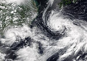
Heavy rainfall was recorded in the Philippines as In-fa, along with another storm called Cempaka, made the southwest monsoon stronger. From July 20 to 21, Iba in Zambales received 198 mm (7.8 inches) of rain. From July 19 to 23, Iba recorded 711.5 mm (28 inches) of rain.
Some roads in Metro Manila were flooded on July 21, but the water was mostly shallow. Light vehicles got stuck. The Supreme Court of the Philippines even stopped work that day because of the floods. The Prinza Dam San Nicolas 1 in Cavite overflowed. Two fishermen in Calatagan, Batangas were rescued after their boat overturned in rough waters.
Continuous rain in Zambales forced 11 families in Castillejos to leave their homes. A landslide made four more families leave their shelters in Olongapo. Widespread flooding also caused work to be canceled in the Freeport Area of Bataan and other government services. Rivers in Pampanga overflowed. In Batac, Ilocos Norte, 25 COVID-19 patients had to be moved from a temporary hospital due to the worsening rain. On July 24, the Marikina River overflowed, reaching 16 meters high, due to the combined effects of In-fa and the monsoon.
Five deaths were reported in the Philippines due to In-fa. Two people in Aguilar, Pangasinan died in a swelling river. Two others in the Ilocos Region died from lightning strikes. One person died in a car accident on Kennon Road, where two others were also injured. Over 202,000 people and 480 villages across Luzon and Visayas were affected by the monsoon rains. Damages to farms were estimated at US$1.98 million. Damages to buildings and roads were US$47,707.
572 houses were damaged, with 143 completely destroyed. 26 cities and towns had power outages. Seven ports stopped working. Over 72,000 people had to leave their homes, and 38,472 people stayed in 365 evacuation centers.
Taiwan's Experience
The large size of In-fa caused heavy rains in Taiwan, leading to many landslides and rockfalls. Trees were knocked down by strong winds, damaging cars and blocking traffic. Power outages were reported in Shilin and Beitou districts. Many boats and ships were guided to ports for safety. From July 21 to 22, Hsinchu County received 269.5 mm (10.6 inches) of rain. Waves of 5 meters (16 feet) were seen in the Matsu Islands.
China's Experience
Before Landfall
The air currents and moisture from In-fa caused record-breaking rainfall and terrible floods in Henan. These floods killed 302 people, and 50 were missing, including 14 in a flooded subway line in Zhengzhou. A high-pressure system combined with In-fa to bring huge amounts of water into the province. The shape of the land in Zhengzhou made the problem worse. A year's worth of rain fell in the city in just over three days. At least 215,200 hectares of land were damaged. Over 90 villages in Xinxiang were flooded. A dam on the Wei River reportedly burst on July 23.
The floods caused 29 out of 30 reservoirs in Zhengzhou to overflow. Many areas were filled with mud, and many riverbanks broke. Some people were trapped without food or water for days. The floods caused over 69 deaths and an estimated US$12.7 billion in damage. At least 1.1 million people were moved to safety, and over 9.3 million people were affected. It's likely that tens of millions were impacted. The Jiangguang Road Tunnel flooded in just five minutes during extreme rain, trapping hundreds of vehicles. A bridge in one area also collapsed.
During Landfall
| Precipitation | Storm | Location | Ref. | ||
|---|---|---|---|---|---|
| Rank | mm | in | |||
| 1 | 1629.0 | 64.13 | Nina 1975 | Banqiao Dam | |
| 2 | 951.0 | 37.4 | In-fa 2021 | Yuyao | |
| 3 | 831.1 | 32.72 | Fitow 2001 | Changjiang County | |
| 4 | 806.0 | 31.73 | Soudelor 2015 | Wenzhou | |
| 5 | 744.8 | 29.32 | Doksuri 2023 | Wangjiayuan Reservoir | |
| 6 | 662.0 | 26.01 | Chanthu 2021 | Dinghai District, Zhoushan | |
| 7 | 600.0 | 24.00 | Haikui 2012 | Anhui Province | |
| 8 | 555.0 | 21.85 | Chanchu 2006 | Zhangpu County | |
Coastal villages and towns experienced major flooding. Subway lines above ground were stopped, and roads in many areas were underwater. A roof outside a subway station blew off and landed on train tracks, causing traffic problems. Workers had trouble getting to their jobs because of In-fa's winds and heavy rain. Much of Shanghai was shut down. The city's weather bureau said Shanghai received over 100 mm (3.9 inches) of rain from July 25 to 26, almost as much as the total rainfall for July (120 mm) in just one day.
Warehouses in Zhengzhou had to stop loading containers and making deliveries. A lot of cargo was stuck at Pudong port because the weather prevented ships from moving. Traffic and road transport were affected by flooding across the region, with at least 6 km (3.7 miles) of road underwater due to storm surge. A freight train going from China to Europe was delayed. In Shanghai, 268 signs and billboards were blown down by July 26. Many businesses closed temporarily, and nearly 500,000 people were moved to shelters. Over 12,700 people were still without power, with over 100,000 having lost power in total. Farm losses were expected to be very high.
Waves several meters high were reported on the Qiantang river in Haining. Heavy rain and strong winds also affected coastal areas in Qidong, Jiangsu, damaging properties. Six very large offshore construction platforms were also affected. Streets in Shanghai were waterlogged. Pictures showed floodwaters reaching the tops of cars. Up to 300 mm (11.8 inches) of rain fell in Jiangsu province. An underground parking garage was flooded.
What Happened After
Philippines' Recovery
On July 26, about US$58,200 worth of food packs were given to affected families in Calabarzon, Central Luzon, Mimaropa, and Western Visayas. About US$16.6 million was set aside for quick response, and US$3.3 million was saved for future aid. Local disaster management groups worked closely with the government to help with recovery.
China's Recovery
There were questions about how well China was prepared for damaging weather events, especially with climate change.
As the floods slowly went down before the typhoon's landfall, authorities began to help clean up. A Henan emergency official said on July 24 that the province would need a big cleaning and disinfecting effort to prevent common outbreaks that happen after floods. Pictures showed workers shoveling mud and removing fallen trees. At least 12,000 temporary shelters opened across Zhejiang Province. Emergency anti-typhoon vessels were used to protect six construction projects. By July 25, a total of 97,915 people were moved to safe areas in Jiangsu when the typhoon hit. Photos showed migrant workers staying in shelters during In-fa.
Because of In-fa's impact, Salmon prices in Shanghai jumped to 135 yuan (US$20.75) per kilogram. Firefighters rescued people trapped by flooding in Zhejiang province. Videos showed firefighters saving 45 trapped locals and a driver stuck in an overturned vehicle. Pumps were used to drain rainwater from floods in Weihui city. Health authorities started a campaign on July 28 to help prevent Mosquitoes. Because In-fa's flooding made conditions very wet, many areas became perfect breeding grounds for insects. This campaign ran from July 29 to 31. Wet markets, old neighborhoods, and construction sites were special concerns.
Coal mining in China was made a priority after the typhoon, due to widespread blackouts. State-run mining companies sent more thermal coal to 27 power plants around Henan province. Over 340,000 tons of thermal coal reached the province on July 26, much more than needed daily. Coal operations were also sped up in other regions, like the Yangtze River Delta Area. Videos from Jiangsu Fire showed rescue crews working to drain floodwater.
China's top economic planner collected 795 million yuan (US$122.4 million) for rebuilding in areas affected by the typhoon and floods. Earlier, China had already given over 3 billion yuan to help with flood control and disaster recovery.
|


