Washington County, Tennessee facts for kids
Quick facts for kids
Washington County
|
|||
|---|---|---|---|
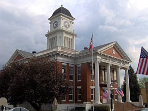
Washington County Courthouse in Jonesborough
|
|||
|
|||

Location within the U.S. state of Tennessee
|
|||
 Tennessee's location within the U.S. |
|||
| Country | |||
| State | |||
| Founded | 1777 | ||
| Named for | George Washington | ||
| Seat | Jonesborough | ||
| Largest city | Johnson City | ||
| Area | |||
| • Total | 330 sq mi (900 km2) | ||
| • Land | 326 sq mi (840 km2) | ||
| • Water | 3.3 sq mi (9 km2) 1.0%% | ||
| Population
(2020)
|
|||
| • Total | 133,001 | ||
| • Estimate
(2023)
|
138,420 |
||
| • Density | 403/sq mi (155.6/km2) | ||
| Time zone | UTC−5 (Eastern) | ||
| • Summer (DST) | UTC−4 (EDT) | ||
| Congressional district | 1st | ||
Washington County is a county in Tennessee. In 2020, about 133,000 people lived here. Its main town, or county seat, is Jonesborough. The biggest city in the county is Johnson City. It is a major center for schools, hospitals, and businesses. Washington County is the oldest county in Tennessee. It was created in 1777 when Tennessee was still part of North Carolina. The county is part of the "Tri-Cities" area, which includes Johnson City, Kingsport, and Bristol.
Contents
History of Washington County
Early Settlements and the Washington District
Washington County's story began in the early 1770s. This was when the Watauga settlements were formed. They were near what is now Elizabethton. When the Revolutionary War started in 1776, the Watauga settlers created the "Washington District." A group called a "committee of safety" governed it. North Carolina first did not accept these settlements. But it later added the district after the settlers stopped attacks from the Cherokee people. The Washington District included all of what is now Tennessee. It became Washington County in 1777.
The State of Franklin and North Carolina
From 1777 to 1784, North Carolina had control over the county. But the people living there felt North Carolina did not help them much. So, in 1784, they formed their own area called the State of Franklin. This was an early try to create a new state, before Kentucky and Vermont joined the United States. However, the State of Franklin did not last. The county returned to North Carolina's control in 1788.
Becoming Part of Tennessee
In 1790, the area became part of the Southwest Territory. Then, in 1796, it joined the United States as the 16th state, Tennessee. Jonesborough, the county seat, is the oldest town in Tennessee. Many of its buildings have been fixed up. They show what life was like between 1790 and 1870.
During the American Civil War, people in Washington County had mixed feelings. Some supported the Union, and some supported the Southern states that wanted to leave. In 1861, Washington County voted to stay in the Union. One of the bridges that was attacked by Union supporters in 1861 was near Watauga. Landon Carter Haynes, a senator for the Confederate side, was from Washington County.
Johnson City, first known as Johnson's Depot, was a big railway hub. It connected the region for moving goods and people. It was home to two important railroads. One was the Carolina, Clinchfield, and Ohio (Clinchfield Railroad). Building it needed 17 tunnels to be dug. The other was the East Tennessee and Western North Carolina Railroad (Tweetsie). Today, many historic railroad buildings in Johnson City are being restored. They show the city's important past as a railway center.
Geography of Washington County
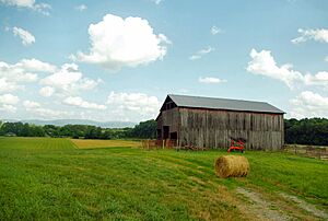
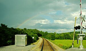
Washington County covers about 330 square miles. Most of this is land, with a small part being water. The western part of the county has long, narrow mountains and valleys. These are part of the Ridge-and-Valley Appalachians. The eastern part of the county is in the Blue Ridge Mountains. This area includes the Bald Mountains and the Unaka Range.
Buffalo Mountain is a long ridge on the county's eastern edge. It has the highest point in the county, Pinnacle Knob, which is 3,520 feet high. A large part of the eastern county is protected by the Cherokee National Forest. Sampson Mountain, in the southeast, has a special wilderness area.
The Nolichucky River flows through the southern part of Washington County. The Watauga River flows through the northern part. It also forms part of the border with Sullivan County. The lower part of the Watauga River is now part of Boone Lake.
Neighboring Counties
- Sullivan County (north)
- Carter County (east)
- Unicoi County (south)
- Greene County (west)
- Hawkins County (northwest)
Protected Natural Areas
- Cherokee National Forest (part)
State Historic Sites
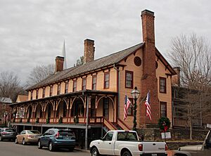
- Chester Inn (state historic site)
- Tipton-Haynes State Historic Site
Main Roads
Population Data
| Historical population | |||
|---|---|---|---|
| Census | Pop. | %± | |
| 1790 | 5,872 | — | |
| 1800 | 6,379 | 8.6% | |
| 1810 | 7,740 | 21.3% | |
| 1820 | 9,557 | 23.5% | |
| 1830 | 10,995 | 15.0% | |
| 1840 | 11,751 | 6.9% | |
| 1850 | 13,861 | 18.0% | |
| 1860 | 14,829 | 7.0% | |
| 1870 | 16,317 | 10.0% | |
| 1880 | 16,181 | −0.8% | |
| 1890 | 20,354 | 25.8% | |
| 1900 | 22,604 | 11.1% | |
| 1910 | 28,968 | 28.2% | |
| 1920 | 34,052 | 17.6% | |
| 1930 | 45,805 | 34.5% | |
| 1940 | 51,631 | 12.7% | |
| 1950 | 59,971 | 16.2% | |
| 1960 | 64,832 | 8.1% | |
| 1970 | 73,924 | 14.0% | |
| 1980 | 88,755 | 20.1% | |
| 1990 | 92,315 | 4.0% | |
| 2000 | 107,198 | 16.1% | |
| 2010 | 122,979 | 14.7% | |
| 2020 | 133,001 | 8.1% | |
| 2023 (est.) | 138,420 | 12.6% | |
| U.S. Decennial Census 1790-1960 1900-1990 1990-2000 2010-2019, 2017 |
|||
2020 Census Information
| Race | Number | Percentage |
|---|---|---|
| White (non-Hispanic) | 112,606 | 84.67% |
| Black or African American (non-Hispanic) | 5,511 | 4.14% |
| Native American | 289 | 0.22% |
| Asian | 1,980 | 1.49% |
| Pacific Islander | 53 | 0.04% |
| Other/Mixed | 6,426 | 4.83% |
| Hispanic or Latino | 6,136 | 4.61% |
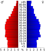
In 2020, Washington County had 133,001 people. There were 55,817 households and 33,838 families living in the county.
Education in Washington County
Washington County has two school districts. The Washington County School District covers most of the county. The Johnson City School District covers most of Johnson City.
Here are some of the schools in Washington County:
- Elementary schools
|
|
- Middle schools
- Boones Creek Middle School
- Jonesborough Middle School. This school was built in 1950 as a high school. It became a middle school in 1971. It has about 500 students in grades 5 through 8.
- High schools
- Asbury Optional High School
- Daniel Boone High School
- David Crockett High School
- Science Hill High School
- University School
Communities in Washington County
Cities
- Johnson City (a small part is in Carter County and Sullivan County)
- Watauga (mostly in Carter County)
Town
- Jonesborough (the county seat)
Census-designated places
These are areas that are like towns but are not officially incorporated as cities or towns.
- Embreeville
- Fall Branch (partial)
- Gray
- Oak Grove
- Spurgeon (partial)
- Telford
Unincorporated communities
These are smaller communities that are not part of any city or town.
- Austin Springs
- Boone
- Boones Creek
- Bowmantown
- Bumpus Cove (partial)
- February
- Lamar
- Limestone
- Midway
- Mountain Home
- South Central
- Stewart Hill
- Sulphur Springs
- Washington College
Notable Residents
- Joseph Hardin, Sr. – A hero from the Revolutionary War. He was a colonel for North Carolina's militia in 1788.
See also
 In Spanish: Condado de Washington (Tennessee) para niños
 | Bessie Coleman |
 | Spann Watson |
 | Jill E. Brown |
 | Sherman W. White |


