
Waterfalls in Ricketts Glen State Park facts for kids

Ricketts Glen State Park in Pennsylvania, USA, is famous for its amazing waterfalls. There are 24 named waterfalls along Kitchen Creek, which flows through three deep, narrow valleys called glens. These waterfalls vary in height, from 9 feet (2.7 m) to the tallest, Ganoga Falls, which is 94 feet (29 m) high!
The park is named after R. Bruce Ricketts, a colonel from the American Civil War. He owned a huge amount of land here in the late 1800s and early 1900s. Luckily, he protected the old, tall trees in the glens from being cut down. The park opened in 1944 and is managed by the Pennsylvania Department of Conservation and Natural Resources (DCNR).
You can see almost all the waterfalls from the Falls Trail. Colonel Ricketts built this trail between 1889 and 1893. The state park later rebuilt it in the 1940s and again in the late 1990s. Many people call the Falls Trail "the most magnificent hike in the state" and one of "the top hikes in the East."
The waterfalls are located where Kitchen Creek flows down the Allegheny Front. This is a steep slope between the Allegheny Plateau in the north and the Ridge-and-Valley Appalachians in the south. The glens are made of sedimentary rocks. These rocks formed up to 370 million years ago during the Devonian and Carboniferous periods. The waterfalls exist because glaciers from the last Ice Age increased the amount of water flowing in Kitchen Creek.
Colonel Ricketts named 21 of the waterfalls. Most are named after Native American tribes and places, or his family and friends. There are ten named falls in Ganoga Glen, eight in Glen Leigh, and between four and six in Ricketts Glen. Different groups, like the DCNR and the United States Geological Survey (USGS), count the falls slightly differently.
Contents
How the Waterfalls Formed
The waterfalls at Ricketts Glen State Park are on the Allegheny Front. This is a natural border between the Allegheny Plateau to the north and the Ridge-and-Valley Appalachians to the south. Kitchen Creek starts on the plateau. It then drops about 1,000 feet (300 m) over 2.25 miles (3.62 km) as it flows down the steep Allegheny Front.
Most of this big drop happens in Glen Leigh and Ganoga Glen. These are two narrow valleys carved by different branches of Kitchen Creek. They meet at a spot called Waters Meet. The Glen Leigh branch has eight named waterfalls. The Ganoga Glen branch has ten named waterfalls. South of Waters Meet, the land is less steep, and there are fewer named waterfalls in the area called Ricketts Glen.
Ancient Rocks and Land Changes
The rocks you see in the park formed between 370 and 340 million years ago. Back then, this area was a coastline of a shallow sea. Over time, high mountains to the east wore down. This created a lot of sediment like clay, sand, and gravel. Huge pressure on this sediment turned it into the rocks found in the park: sandstone, shale, siltstone, and conglomerates.

About 300 to 250 million years ago, the Allegheny Plateau, Allegheny Front, and Appalachian Mountains all formed. This happened when the land that became Africa crashed into what became North America. This collision formed a supercontinent called Pangaea. Since then, streams and weather have worn away up to 5,000 feet (1,500 m) of rock.
The last major factor in shaping the park was the Ice Age. Over the past million years, at least three big ice ages have occurred.
How Glaciers Created the Falls
The glaciers made Kitchen Creek special. It's the only stream in the area with "an almost continuous series of waterfalls." Before the last Ice Age, Kitchen Creek and Phillips Creek (to the east) were similar. Both had small drainage areas and flowed down the Allegheny Front.
But then, about 20,000 years ago, the glaciers started to melt and retreat. They formed temporary dams on two nearby streams on the Allegheny Plateau. These were South Branch Bowman Creek to the northeast and Big Run to the northwest.
As the glaciers moved away, melting ice and lakes cut new channels. This sent the water from South Branch Bowman Creek into the Glen Leigh branch of Kitchen Creek. The glaciers also left piles of debris 20 to 30 feet (6.1 to 9.1 m) thick. This blocked water from draining into Big Run. Instead, water from Ganoga Lake and the area that became Lake Jean was sent into the Ganoga Glen branch of Kitchen Creek.
These changes added about 7 square miles (18 km²) to Kitchen Creek's drainage area. This increased its size by over 50 percent!
The Future of the Falls
More water flowing in Kitchen Creek meant it started cutting into the rock more. This is how the waterfalls formed. Before, Kitchen Creek's slope was good for its smaller water flow. But with more water, the creek in the glens is now too steep.
As Kitchen Creek keeps cutting into the rock, its slope will become less steep. Eventually, its flow and slope might become similar to other nearby creeks. This process could take so long that another ice age might happen before it's finished!
Waterfall Types and Rocks
The park's waterfalls show two main types of rock. The newer rock is the Huntley Mountain Formation. It has layers of olive green to gray sandstone and gray to red shale. The older rock is the Catskill Formation. It's made of red shale and siltstone. The harder Huntley Mountain Formation sits on top. It has protected the Allegheny Front from eroding as much as the softer Catskill Formation below.

Geologists group the waterfalls into different types:
- Wedding-cake falls: These falls look like a wedding cake, with water flowing down a series of small steps. In the park, these usually flow over thin layers of Huntley Mountain Formation sandstone.
- Bridal-veil falls: Water falls straight down over a ledge into a deep pool below called a plunge pool. In the park, these falls are often over Catskill Formation rocks or the red shale and sandstone of the Huntley Formation. The hard rock that forms the ledge is usually grey sandstone. The softer red shale below gets worn away by the water, sand, and gravel, creating the plunge pool.
Another book, Pennsylvania waterfalls: a guide for hikers and photographers, uses four types:
- Falls: Same as bridal-veil, where water drops freely from a ledge.
- Cascade: Water flows down a very steep surface with terraces (like steps).
- Slide: Water flows down a wide, smooth, steep surface.
- Chute: Water is squeezed by rocks as it falls down a narrow slide.
Park History

The land where Ricketts Glen State Park is located was once home to the Susquehannock people. Their numbers dropped due to disease and wars. By 1675, they had either died out or joined other tribes. Later, the Iroquois controlled the land. They allowed other tribes, like the Shawnee and Lenape, to settle there.
In 1768, the British bought this land from the Iroquois. After the American Revolutionary War, Native Americans mostly left Pennsylvania. In 1890, a Native American pot was found under a rock ledge on Kitchen Creek. It was found by Murray Reynolds, for whom a waterfall is named.
The Ricketts Family and the Park
The Ricketts family started buying land in this area in 1851. Elijah Ricketts and his brother Clemuel bought about 5,000 acres (2,000 ha). They built a stone house by what is now Ganoga Lake. They ran it as a lodge and tavern.
Elijah's son, R. Bruce Ricketts, became a colonel in the Union Army during the American Civil War. After the war, he bought land from his father. Eventually, he owned over 80,000 acres (32,000 ha), including the glens and waterfalls.
The Ricketts family and other settlers didn't know about the glens and waterfalls until about 1865. Two of the Ricketts' guests discovered them while fishing. In 1872, Ricketts added a three-story wooden part to the stone house. It opened as the North Mountain House hotel in 1873.

Colonel Ricketts named 21 of the waterfalls. Many have Native American names, while others are named after his family and friends. In 1889, Ricketts hired Matt Hirlinger and five other men to build the trails along Kitchen Creek. It took them four years to finish the trails and stone steps through the glens.
Ricketts made his money by cutting down trees on most of his land. But he made sure to save the glens and their old-growth forests. He died in 1918. His family later sold much of the land.
Becoming a State Park
In 1942, the Commonwealth of Pennsylvania bought 1,261 acres (510 ha) from the Ricketts family. This included the glens and their waterfalls, for $82,000. Ricketts Glen State Park officially opened in 1944. The state bought even more land from the family later. Today, the park covers about 10,000 acres (4,000 ha) from the Ricketts family and 3,000 acres (1,200 ha) from others.

When the park opened, the state rebuilt the Falls Trail. They replaced all the stone steps and added signs. For safety, they replaced old log bridges with new footbridges that had handrails. They also removed some overhanging rocks and changed parts of the trail.
In 1969, the Glens Natural Area was named a National Natural Landmark. This means it's a special place that will be protected. In 1996, heavy rains washed out two bridges on the Falls Trail. The Army National Guard even used a helicopter to drop poles into the glens to help rebuild them!
In 1997, ice climbing was allowed in Ganoga Glen for the first time. Local fire companies also trained to rescue people who might get hurt in icy conditions. A big four-year project started in 1998 to fix and improve the Falls Trail. Workers carried materials in on foot to make the trail safer and reduce erosion.
In 2001, a book called the Falls Trail "the most magnificent hike in the state." Backpacker magazine readers also voted it the best hike in Pennsylvania in 2009.
Exploring the Waterfalls

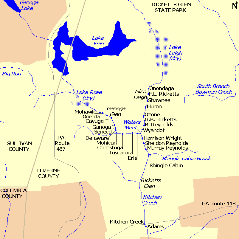
Kitchen Creek flows through the park's three glens: Ricketts Glen, Glen Leigh, and Ganoga Glen. The waterfalls are listed in order as you would see them if you hiked upstream along Kitchen Creek.
The Falls Trail is a 7.1-mile (11.4 km) loop hike.
- Starting at PA 118, you hike 1.8 miles (2.9 km) north through Ricketts Glen to Waters Meet.
- At Waters Meet, the trail splits. If you go through Glen Leigh, it's 1.2 miles (1.9 km) north to the Highland Trail.
- Then, you walk 1.0 mile (1.6 km) west along the Highland Trail to Ganoga Glen.
- From there, it's 1.3 miles (2.1 km) through Ganoga Glen back to Waters Meet.
- Finally, you retrace your steps 1.8 miles (2.9 km) through Ricketts Glen back to PA 118.
Each waterfall description includes its name, height, elevation (how high it is above sea level), and coordinates (its exact location). We also mention its type (falls, cascade, slide, or chute). There are notes with more information about each waterfall, its name's origin, and its location on the trail.
Ricketts Glen Waterfalls
Ricketts Glen is the part of Kitchen Creek valley south of Waters Meet. It's the longest glen on the Falls Trail, at 1.8 miles (2.9 km) between Pennsylvania Route 118 and Waters Meet. The three northernmost waterfalls are close to Waters Meet.
The southern part of this glen has large areas of old-growth forest, especially hemlock trees. Ricketts Glen is mostly in the Catskill Formation rock, and all the falls here have plunge pools.
The number of named waterfalls in Ricketts Glen varies depending on the source. Only one book names Shingle Cabin Falls, which is on a smaller stream that flows into Kitchen Creek. The names of the waterfalls at the southern end, near PA 118, are also debated. The official park map only names Adams Falls.
| Name | Height | Elevation | Coordinates | Type | Photo |
|---|---|---|---|---|---|
| Adams | 36 feet (11.0 m) |
1,214 feet (370 m) |
41°17′54″N 76°16′23″W / 41.29833°N 76.27306°W | chute | |
| Adam Kale was a watchman on Kitchen Creek. Adams Falls is the most beautiful and easiest to reach waterfall in the park. It's the only named waterfall south of Pennsylvania Route 118 and not on the Falls Trail. You can reach it from the parking lot on the 1-mile (1.6 km) Evergreen Trail. Adams Falls has carved a narrow chute in the rock. Its lower plunge pool, Leavenworth Pool, is 30 feet (9.1 m) wide and 8 to 10 feet (2.4 to 3.0 m) deep. | |||||
| Kitchen Creek | 9 feet (2.7 m) |
1,234 feet (376 m) |
41°17′57″N 76°16′26″W / 41.29917°N 76.27389°W | falls | |
| Kitchen Creek Falls is right under the Pennsylvania Route 118 (PA 118) bridge. It has carved a narrow chute, less than 3 feet (0.91 m) wide. It's the shortest named waterfall in the park. While visible from the Falls Trail, it's not one of the DCNR's 22 named waterfalls. | |||||
| Shingle Cabin | 25 feet (7.6 m) |
1,378 feet (420 m) |
41°18′56″N 76°16′23″W / 41.31556°N 76.27306°W | cascade | |
| Shingle Cabin Falls is on Shingle Cabin Brook, a small stream that flows into Kitchen Creek. The Falls Trail is on the opposite side of the creek from the falls. Leaves on the trees often block the view. This waterfall is not officially named by the DCNR. | |||||
| Murray Reynolds | 16 feet (4.9 m) |
1,447 feet (441 m) |
41°19′06″N 76°16′26″W / 41.31833°N 76.27389°W | chute | |
| G. Murray Reynolds (1838–1904) was a colonel and politician. He was also the brother-in-law of R. B. Ricketts. This waterfall was once called "Pulpit Falls" because of a rock shaped like a pulpit in the middle of the chute. It's the first DCNR-named waterfall you see when hiking north on the Falls Trail. | |||||
| Sheldon Reynolds | 36 feet (11.0 m) |
1,476 feet (450 m) |
41°19′09″N 76°16′28″W / 41.31917°N 76.27444°W | falls, then cascade | |
| Sheldon Reynolds (1845–1895) was a lawyer and historian, and also R. B. Ricketts' brother-in-law. As you approach this waterfall from the south, you can see Harrison Wright Falls in the distance above it. | |||||
| Harrison Wright | 27 feet (8.2 m) |
1,519 feet (463 m) |
41°19′14″N 76°16′31″W / 41.32056°N 76.27528°W | falls | |
| Harrison Wright (1850–1885) was a lawyer and mineralogist who worked with R. Bruce Ricketts. This waterfall is often called "perhaps the most photogenic falls in the park." It's just a short distance south of Waters Meet. | |||||


Glen Leigh Waterfalls

Many people call Glen Leigh "the loveliest part of the entire trail." It's rugged and steep, with rock walls on one side and rushing water on the other. It has some of the most amazing waterfalls in the park.
Glen Leigh was named after Lake Leigh. R. B. Ricketts named the lake for his second daughter, Frances Leigh. In 1907, R. B. Ricketts built a dam upstream of the waterfalls. He hoped to use Lake Leigh to make electricity. But the dam wasn't built well and couldn't make power. The lake was drained in 1956. Most of Glen Leigh is in the Huntley Mountain Formation rock.
Glen Leigh has eight named waterfalls in 0.64 miles (1.03 km). You can reach it from Waters Meet in the south or from the Lake Leigh trailhead parking lot in the north. The Highland Trail connects the northern ends of Glen Leigh and Ganoga Glen.
| Name | Height | Elevation | Coordinates | Type | Photo |
|---|---|---|---|---|---|
| Wyandot | 15 feet (4.6 m) |
1,608 feet (490 m) |
41°19′20″N 76°16′29″W / 41.32222°N 76.27472°W | falls | |
| Wyandot Falls is one of two named waterfalls visible from Waters Meet. It's the first named falls in Glen Leigh. The Wyandots (also known as Hurons) were an Iroquoian-speaking people. They once lived in Ontario, Canada. | |||||
| B. Reynolds | 40 feet (12.2 m) |
1,637 feet (508 m) |
41°19′24″N 76°16′29″W / 41.32333°N 76.27472°W | falls | |
| Benjamin Reynolds (1840–1913) was a banker and R. B. Ricketts' brother-in-law. This is the second named falls in Glen Leigh. When the water is low, it looks like a "horse tail" falls. | |||||
| R. B. Ricketts | 36 feet (11.0 m) |
1,676 feet (510 m) |
41°19′27″N 76°16′27″W / 41.32417°N 76.27417°W | cascade, then cascade | |
| Robert Bruce Ricketts (1839–1918) was a colonel in the Union Army. He fought at Gettysburg. He owned a lot of land and saved the old-growth forest in what became Ricketts Glen State Park, which is named for him. This is the third named falls in Glen Leigh. | |||||
| Ozone | 60 feet (18.3 m) |
1,752 feet (534 m) |
41°19′32″N 76°16′29″W / 41.32556°N 76.27472°W | cascade | |
| This waterfall is named for the Ozone hiking club. Ozone Falls is the tallest in Glen Leigh and the second tallest in the park. It's the fourth named falls in Glen Leigh. The Falls Trail climbs a switchback next to the falls and crosses Kitchen Creek just above it. | |||||
| Huron | 41 feet (12.5 m) |
1,795 feet (547 m) |
41°19′36″N 76°16′27″W / 41.32667°N 76.27417°W | slide | |
| Huron Falls makes a 90-degree turn as it slides down sandstone rock. It's the fifth named falls in Glen Leigh. The Hurons were an Iroquoian-speaking people, also known as the Wyandots. They once lived in Ontario, Canada. | |||||
| Shawnee | 30 feet (9.1 m) |
1,880 feet (570 m) |
41°19′40″N 76°16′26″W / 41.32778°N 76.27389°W | falls, then falls | |
| Shawnee Falls is the sixth named falls in Glen Leigh. Shawnee and Huron falls are carving a large overhanging cliff. Some think they were once one waterfall. The Shawnee were an Algonquian-speaking people who came to Pennsylvania as refugees. | |||||
| F. L. Ricketts | 38 feet (11.6 m) |
1,988 feet (606 m) |
41°19′46″N 76°16′26″W / 41.32944°N 76.27389°W | slide | |
| Frank L. Ricketts (1843–1908) was R. B. Ricketts' younger brother. He managed the Ricketts' North Mountain House hotel. He was deaf from scarlet fever as a child. This is the seventh named falls in Glen Leigh. The trail near this falls was moved for safety. | |||||
| Onondaga | 15 feet (4.6 m) |
2,077 feet (633 m) | 41°19′52″N 76°16′26″W / 41.33111°N 76.27389°W | cascade | |
| Onondaga Falls is the eighth and last named falls in Glen Leigh. The trail to this waterfall was rebuilt after a storm. The Onondaga are an Iroquoian-speaking people and were one of the original members of the Iroquois Confederation. They were important leaders in the Iroquois. | |||||


Ganoga Glen Waterfalls


By 1875, Ricketts had named the tallest waterfall Ganoga Falls. In 1881, he renamed Long Pond as Ganoga Lake. A senator suggested the name Ganoga, an Iroquoian word. He said it meant "water on the mountain" in the Seneca language. Ganoga Lake is where the branch of Kitchen Creek that flows through Ganoga Glen begins.
A dam was built upstream in Ganoga Glen in 1842. Ricketts made it stronger around 1905 to generate electricity. He renamed the water body Lake Rose (Rose is a Ricketts family name). However, this dam also didn't work well and was drained in 1969. Ganoga Glen is not as steep as Glen Leigh. Both glens are mostly in the Huntley Mountain Formation rock.
Ganoga Glen has ten named waterfalls in 1.1 miles (1.8 km). You can reach it from Waters Meet in the south or from the Lake Rose trailhead parking lot in the north. The Highland Trail connects the northern ends of Ganoga Glen and Glen Leigh.
One hiker wrote that Ganoga Glen has his "favorite place" in the park. He said the trail goes around ledges and under overhanging rocks, right next to the waterfalls. The sound of the falls is very loud against the rocks.
| Name | Height | Elevation | Coordinates | Type | Photo |
|---|---|---|---|---|---|
| Erie | 47 feet (14.3 m) |
1,608 feet (490 m) |
41°19′18″N 76°16′40″W / 41.32167°N 76.27778°W | cascade | |
| Erie Falls is one of two named waterfalls visible from Waters Meet. It's the first named falls in Ganoga Glen. The Erie were an Iroquoian-speaking people who lived near Lake Erie. They were defeated by the Iroquois by 1656. | |||||
| Tuscarora | 47 feet (14.3 m) |
1,713 feet (522 m) |
41°19′17″N 76°16′46″W / 41.32139°N 76.27944°W | cascade, then falls | |
| Tuscarora Falls is the second named falls in Ganoga Glen. The Tuscarora are an Iroquoian-speaking people who originally lived in North Carolina. They later moved to New York and became the sixth member of the Iroquois Confederation. | |||||
| Conestoga | 17 feet (5.2 m) |
1,824 feet (556 m) |
41°19′16″N 76°16′56″W / 41.32111°N 76.28222°W | slide | |
| Conestoga Falls is the third named falls in Ganoga Glen. The Conestoga or Susquehannocks were an Iroquoian-speaking people who lived on the Susquehanna River. After being defeated by the Iroquois, the last members were killed in 1763. | |||||
| Mohican | 39 feet (11.9 m) |
1,788 feet (545 m) |
41°19′18″N 76°16′58″W / 41.32167°N 76.28278°W | slide, then slide | |
| Mohican Falls is the fourth named falls in Ganoga Glen. The Mohicans were an Algonquian-speaking people who originally lived on the upper Hudson River. They later lost a war with the Mohawk nation. Mohican Falls has two slides, one above the other. | |||||
| Delaware | 37 feet (11.3 m) |
1,824 feet (556 m) |
41°19′20″N 76°16′59″W / 41.32222°N 76.28306°W | slide | |
| Delaware Falls is the fifth named falls in Ganoga Glen. The Delaware or Lenape are an Algonquian-speaking people who originally lived along the Delaware River. They began selling land to William Penn in 1682. | |||||
| Seneca | 12 feet (3.7 m) |
1,857 feet (566 m) |
41°19′22″N 76°16′59″W / 41.32278°N 76.28306°W | slide | |
| Seneca Falls is the sixth named falls in Ganoga Glen. The Seneca were an Iroquoian-speaking people and the westernmost of the original five tribes of the Iroquois Nation. They were known as the "Keepers of the Western Door." | |||||
| Ganoga | 94 feet (28.7 m) |
1,962 feet (598 m) |
41°19′26″N 76°17′02″W / 41.32389°N 76.28389°W | cascade | |
| Ganoga Falls is the seventh named falls in Ganoga Glen. It's called "the park's crown jewel." The creek changes direction near the top, making the falls look different from various angles. Short paths lead from the Falls Trail to the base and near the top of Ganoga Falls. | |||||
| Cayuga | 11 feet (3.4 m) |
2,041 feet (622 m) |
41°19′31″N 76°17′06″W / 41.32528°N 76.28500°W | cascade | |
| Cayuga Falls is the eighth named falls in Ganoga Glen. The Cayuga are an Iroquoian-speaking people and one of the five original members of the Iroquois. Their lands were between the central Onondaga and the westernmost Seneca. | |||||
| Oneida | 13 feet (4.0 m) |
2,126 feet (648 m) |
41°19′36″N 76°17′14″W / 41.32667°N 76.28722°W | falls | |
| Oneida Falls is the ninth named falls in Ganoga Glen. The Oneida are an Iroquoian-speaking people and one of the five original members of the Iroquois. Their lands were between the central Onondaga and the easternmost Mohawk. They supported the United States during the American Revolutionary War. | |||||
| Mohawk | 37 feet (11.3 m) |
2,165 feet (660 m) |
41°19′39″N 76°17′14″W / 41.32750°N 76.28722°W | falls, then slide | |
| Mohawk Falls is the tenth and last named falls in Ganoga Glen. It's also close to the Lake Rose trailhead parking lot. The Mohawk were an Iroquoian-speaking people and the easternmost of the original five tribes of the Iroquois Nation. They were known as the "Keepers of the Eastern Door." | |||||


Elevation Changes in the Glens
- The highest point in Ganoga Glen, near Mohawk Falls, is at 2,165 feet (660 m). The lowest point, where it meets Waters Meet, is at 1,578 feet (481 m). This is a drop of 587 feet (179 m) over 1.1 miles (1.8 km).
- In Glen Leigh, the highest point near Onondaga Falls is at 2,077 feet (633 m). The lowest point, where it meets Waters Meet, is at 1,565 feet (477 m). This is a drop of 512 feet (156 m) over 0.73 miles (1.17 km). Glen Leigh is steeper than Ganoga Glen.
- Ricketts Glen is less steep. It drops about 360 feet (110 m) over 1.8 miles (2.9 km) between Waters Meet and Pennsylvania Route 118.
