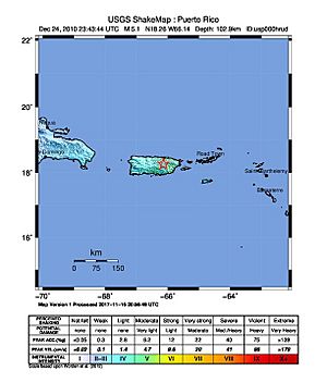
2010 Aguas Buenas earthquake facts for kids
| UTC time | 2010-12-24 23:43:44 |
|---|---|
| USGS-ANSS | ComCat |
| Local date | December 24, 2010 |
| Local time | 19:43:44 |
| Magnitude | Mw 5.1 ML 5.4 |
| Depth | 63.9 miles (102.9 km) |
| Epicenter | 18°15′36″N 66°08′06″W / 18.260°N 66.135°W |
| Fault | Great Northern Puerto Rico fault zone (GNPRfz) |
| Type | Strike-slip |
| Areas affected | Puerto Rico |
| Total damage | Limited, localized. |
| Max. intensity | VI (Strong) |
| Casualties | None |
The 2010 Aguas Buenas earthquake was a notable earthquake that happened on December 24, 2010. It is also known as the 2010 Christmas Eve earthquake (in Spanish, Temblor de Nochebuena de 2010). The earthquake struck at 7:43 p.m. local time in Aguas Buenas, Puerto Rico.
This earthquake had a strength of 5.1 on the moment magnitude scale. This scale measures the total energy released by an earthquake. The shaking felt on the ground was rated as VI (Strong) on the Mercalli intensity scale. This scale describes how people feel an earthquake and the damage it causes.
It was the biggest earthquake in Puerto Rico since May 2010. It was also the strongest earthquake to affect the San Juan area since 1975. People felt the earthquake all over Puerto Rico. It was also felt in the nearby islands of Vieques, Culebra, the U.S. Virgin Islands, and the British Virgin Islands. Some people even felt it in the Dominican Republic, across the Mona Passage.
What Caused the Earthquake?

The earthquake started deep underground in the Great Northern Puerto Rico fault zone (GNPRfz). A fault zone is a place where large cracks in the Earth's crust are found. This area is in the central eastern mountainous part of Puerto Rico. It was located between the Juan Asencio and Sonadora areas of Aguas Buenas. This spot is about 7 miles (11 km) from Caguas and 14 miles (23 km) from San Juan.
This fault zone is where two huge pieces of the Earth's crust, called tectonic plates, meet. These are the North American and Caribbean plates. The area is complex, with different types of plate movement. The earthquake was a strike-slip type, meaning the plates slid past each other horizontally.
When the earthquake first happened, it was reported as a 5.4 on the Richter scale. After the main earthquake, there were two smaller earthquakes called aftershocks. These measured 4.8 and 4.7 and happened about 30 minutes later. Because the earthquake started on land and was not extremely large, it did not cause a tsunami (a giant ocean wave).
The strongest shaking was felt in the towns of Aguas Buenas, Bayamón, San Lorenzo, and Caguas. Moderate to strong shaking was felt throughout the San Juan metropolitan area. More than 4,000 people reported feeling the earthquake to the USGS and the Puerto Rico Seismic Network.
Many people felt this earthquake because it happened on land, close to major cities. It also occurred during Christmas Eve celebrations. At this time, many families were gathered together, often indoors or at church. Emergency services in Bayamón and Guaynabo received over 50 calls.
Damage Caused by the Earthquake
The earthquake was felt widely across Puerto Rico and the United States Virgin Islands. There were some early reports of small, local damage in several towns. These included Adjuntas, Aguas Buenas, Arecibo, Arroyo, Ceiba, Coamo, Fajardo, Humacao, Juncos, Las Marías, Las Piedras, Mayagüez, Naranjito, Patillas, Salinas, and San Lorenzo.
Some areas, like Aguas Buenas and Caguas, also reported power outages. Luckily, there were no deaths or major damage to buildings. There were also no reports of serious injuries.
 | James Van Der Zee |
 | Alma Thomas |
 | Ellis Wilson |
 | Margaret Taylor-Burroughs |

