Atoka County, Oklahoma facts for kids
Quick facts for kids
Atoka County
|
|
|---|---|

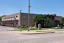
The Atoka County Courthouse in Atoka.
|
|

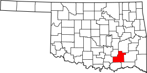
Location within the U.S. state of Oklahoma
|
|
 Oklahoma's location within the U.S. |
|
| Country | |
| State | |
| Founded | 1907 |
| Seat | Atoka |
| Largest city | Atoka |
| Area | |
| • Total | 990 sq mi (2,600 km2) |
| • Land | 976 sq mi (2,530 km2) |
| • Water | 14 sq mi (40 km2) 1.5%% |
| Population
(2020)
|
|
| • Total | 14,143 |
| • Density | 14.29/sq mi (5.516/km2) |
| Time zone | UTC−6 (Central) |
| • Summer (DST) | UTC−5 (CDT) |
| Congressional district | 2nd |
Atoka County is a county located in the state of Oklahoma. In 2020, about 14,143 people lived there. The main town and county seat is Atoka.
This county was created before Oklahoma became a state. It was formed from land that belonged to the Choctaw Nation. The county is named after a Choctaw Chief called Atoka. Today, Atoka County is still part of the Choctaw Nation's reservation lands.
Contents
History of Atoka County
The land that is now Atoka County was once part of the Choctaw Nation. The Choctaw tribe moved here in the early 1830s. They were forced to leave their homes in the southeastern United States and move to what was called Indian Territory.
The Choctaw Nation divided its land using natural features like mountains and rivers. This was different from how Oklahoma later set up its counties, which used straight lines. The area of Atoka County was part of the Pushmataha District within the Choctaw Nation. It included parts of what were then called Atoka, Blue, and Jack's Fork counties.
The Choctaw people named their Atoka County after Chief Atoka. He was a leader who guided a group of Choctaw from Georgia to Indian Territory. When Oklahoma became a state, the name "Atoka" was kept for the new county.
In 1858, the Butterfield Overland Mail started a stagecoach route through the area. This route carried people, mail, and goods. There were several stops, including Waddell's, Geary's, and Boggy Depot.
During the American Civil War, Confederate soldiers set up a supply base called Camp Boggy Depot here. After the war, the town of Atoka was founded. In 1872, the Missouri-Kansas-Texas Railway built a train track through the county. This railroad went through Atoka, which helped the town grow. However, it bypassed Boggy Depot, which led to that town's decline.
For a long time, Atoka County's economy relied on coal mining, limestone quarrying, forestry, and farming. By the mid-1900s, raising cattle became the main business. A big employer in the county is the Mack H. Alford Correctional Center. This is a medium-security prison that opened in 1933.
Geography of Atoka County
Atoka County is located in southeastern Oklahoma. It is part of a 10-county area known as Choctaw Country, which is popular for tourism. The county covers about 990 square miles. Most of this (976 square miles) is land, and about 14 square miles (1.5%) is water.
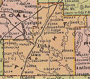
Several creeks flow through Atoka County, including North Boggy, Clear Boggy, and Muddy Boggy Creek. These creeks all flow into the Red River. McGee Creek also flows into Muddy Boggy Creek. The Atoka Reservoir is in the northern part of the county.
The Ouachita Mountains are found in the eastern part of the county. In the north and west, the land is flatter, with areas like the Sandstone Hills and Coastal Plains. These flatter areas are good for farming.
About 12 miles southwest of the town of Atoka is Boggy Depot State Park. This park is a historic site where a large community once stood along the old Butterfield Overland Mail stagecoach route.
A geological time period called the Katian Age is named after Katy Lake. This lake is two miles northeast of Atoka. The official starting point for the Katian stage, known as a GSSP, is at the Black Knob Ridge Section in the county.
Major roads
 U.S. Highway 69
 U.S. Highway 75
 State Highway 3
 State Highway 7
- State Highway 43
- Indian Nation Turnpike
Neighboring counties
- Pittsburg County (north)
- Pushmataha County (east)
- Choctaw County (southeast)
- Bryan County (south)
- Johnston County (west)
- Coal County (northwest)
Population of Atoka County
| Historical population | |||
|---|---|---|---|
| Census | Pop. | %± | |
| 1910 | 13,808 | — | |
| 1920 | 20,862 | 51.1% | |
| 1930 | 14,533 | −30.3% | |
| 1940 | 18,702 | 28.7% | |
| 1950 | 14,269 | −23.7% | |
| 1960 | 10,352 | −27.5% | |
| 1970 | 10,972 | 6.0% | |
| 1980 | 12,748 | 16.2% | |
| 1990 | 12,778 | 0.2% | |
| 2000 | 13,879 | 8.6% | |
| 2010 | 14,182 | 2.2% | |
| 2020 | 14,143 | −0.3% | |
| U.S. Decennial Census 1790-1960 1900-1990 1990-2000 2010 |
|||
In 2010, there were 14,182 people living in Atoka County. The population density was about 14 people per square mile. About 73.8% of the people were White, 13.8% were Native American, and 3.7% were Black or African American.
About 23.6% of the population was under 18 years old. About 14.8% of the people were 65 years or older. The average age in the county was 38 years.
Towns and Communities
City
- Atoka (this is the county seat, or main town)
Towns
Census-designated places
These are areas that are like towns but are not officially incorporated as cities or towns.
Other small communities
- Bentley
- Bethany
- Blackjack
- Boehler
- Boggy Depot
- Bruno
- Burg
- Centerpoint
- Chockie
- Cook
- Crystal
- Daisy
- Dok
- East Allison
- East Talico
- Farris
- Flora
- Forrest Hill
- Fugate
- Goss
- Grassy Lake
- Half Bank Crossing
- Harmony
- Hickory Hill
- High Hill
- Hopewell
- Iron Stob
- Limestone Gap
- Lone Pine
- Mayers Chapel
- McGee Valley
- Mt. Carmel
- Mt. Olive
- Negro Bend
- New Hope
- Nix
- Old Farris
- Patapoe
- Payton Crossing
- Pine Springs
- Plainview
- Pleasant Hill
- Redden
- Reynolds
- Rock Springs
- Standing Rock
- Star
- Taloah
- Valley View
- Voca
- Wards Chapel
- Webster
- Wesley
- West Allison
- West Telico
- Wilson
Schools in Atoka County
Many different school districts serve students from kindergarten through 12th grade:
- Atoka Public Schools
- Caddo Public Schools
- Caney Public Schools
- Clayton Public Schools
- Coalgate Public Schools
- Coleman Public Schools
- Harmony Public School
- Kiowa Public Schools
- Pittsburg Public Schools
- Rock Creek Public Schools
- Stringtown Public Schools
- Tushka Public Schools
- Wapanucka Public Schools
There is also one elementary school district, which is for younger students:
- Lane Public School
The Farris Public School district used to operate as an elementary school district, but it closed in 2013 and joined the Lane district.
Historic Places
The following places in Atoka County are listed on the National Register of Historic Places. This means they are important historical sites.
- Atoka Armory, Atoka
- Atoka Community Building, Atoka
- Isaac Billy Homestead and Family Cemetery, Daisy
- Boggy Depot Site, Atoka
- First Methodist Church Building, Atoka
- First Oil Well in Oklahoma, Wapanucka
- Indian Citizen Building, Atoka
- Captain Charles LeFlore House, Limestone Gap
- Masonic Temple, Atoka
- Bo McAlister Site, Wapanucka
- Middle Boggy Battlefield Site and Confederate Cemetery, Atoka
- Old Atoka County Courthouse, Atoka
- Old Atoka State Bank, Atoka
- Pioneer Club, Atoka
- Joe Ralls House, Atoka
- Captain James S. Standley House, Atoka
- Waddell's Station Site, Wesley
- Zweigel Hardware Store Building, Atoka
See also
 In Spanish: Condado de Atoka para niños
 | Georgia Louise Harris Brown |
 | Julian Abele |
 | Norma Merrick Sklarek |
 | William Sidney Pittman |


