Baker County, Oregon facts for kids
Quick facts for kids
Baker County
|
||
|---|---|---|
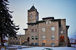
Baker County Courthouse in Baker City
|
||
|
||
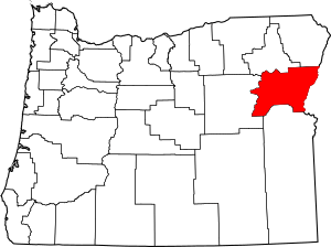
Location within the U.S. state of Oregon
|
||
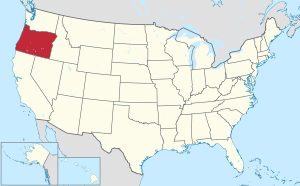 Oregon's location within the U.S. |
||
| Country | ||
| State | ||
| Founded | September 22, 1862 | |
| Named for | Edward D. Baker | |
| Seat | Baker City | |
| Largest city | Baker City | |
| Area | ||
| • Total | 3,088 sq mi (8,000 km2) | |
| • Land | 3,068 sq mi (7,950 km2) | |
| • Water | 20 sq mi (50 km2) 0.6% | |
| Population
(2020)
|
||
| • Total | 16,668 | |
| • Estimate
(2023)
|
16,912 |
|
| • Density | 5.22/sq mi (2.02/km2) | |
| Time zone | UTC−8 (Pacific) | |
| • Summer (DST) | UTC−7 (PDT) | |
| Congressional district | 2nd | |
Baker County is one of 36 counties in the U.S. state of Oregon. In 2020, about 16,668 people lived there. The main city and county seat is Baker City.
The county was created on September 22, 1862. It was formed from a part of Wasco County. Later, its size changed a few times. Parts of it became Union County and Malheur County. The county's borders were last set in 1901.
Baker County was named after Edward Dickinson Baker. He was a senator from Oregon. Senator Baker died in 1861 during the Civil War. The county is located in what is known as Eastern Oregon.
Contents
History of Baker County
The first people from the eastern U.S. traveled through this area. They followed the Oregon Trail to the Willamette Valley. They did not know about the gold and other riches nearby. You can still see wagon ruts from these early travelers. These ruts are near Baker City at Flagstaff Hill. They stretch for about 15 kilometers (9 miles).
Oregon became a state in 1859. In 1861, gold was found in eastern Wasco County. This led to a big gold rush. The area quickly became a major gold producer in the Northwest. In September 1862, the state government created Baker County. It was made from part of Wasco County. Later, Union County and Malheur County were formed from Baker County. The county's borders were last changed in 1901. This is when an area near the Powder River was added back.
Auburn was the first county seat. It was a busy mining town with 5,000 people. But when the gold ran out, Auburn's population dropped. In 1868, people voted to make Baker City the new county seat. Baker City became an official city in 1874.
The number of people in Baker County grew a lot from 1880 to 1910. This was mainly because of the Sumpter Valley Railroad. This railroad helped lumber and mining businesses grow.
In 1914, Fern Hobbs declared a special order in Copperfield. She did this for Governor Oswald West. This was the first time such an order was used in Oregon since the Civil War.
From 1915 to 1946, William H. Strayer served Baker County in the state government. He served longer than anyone else in Oregon's history at that time.
Geography of Baker County
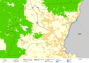
Baker County covers about 3,088 square miles (7,998 square kilometers). Most of this area, about 3,068 square miles (7,946 square kilometers), is land. Only a small part, about 20 square miles (52 square kilometers), is water.
The land in Baker County is mostly rugged. About 30 percent of the county is covered with forests. The highest point is Red Mountain. It is about 9,560 feet (2,914 meters) high. This mountain is near the county's northern border. The Snake River forms the eastern edge of the county. The land generally slopes down towards the Snake River valley.
Counties Nearby
- Union County - north
- Wallowa County - northeast
- Adams County, Idaho - east (different time zone border)
- Washington County, Idaho - southeast (different time zone border)
- Malheur County - south (different time zone border)
- Grant County - west
Protected Natural Areas
- Deer Flat National Wildlife Refuge (part)
- Hells Canyon National Recreation Area (part)
- Malheur National Forest (part)
- Whitman National Forest (part)
People of Baker County
| Historical population | |||
|---|---|---|---|
| Census | Pop. | %± | |
| 1870 | 2,804 | — | |
| 1880 | 4,616 | 64.6% | |
| 1890 | 6,764 | 46.5% | |
| 1900 | 15,597 | 130.6% | |
| 1910 | 18,076 | 15.9% | |
| 1920 | 17,929 | −0.8% | |
| 1930 | 16,754 | −6.6% | |
| 1940 | 18,297 | 9.2% | |
| 1950 | 16,175 | −11.6% | |
| 1960 | 17,295 | 6.9% | |
| 1970 | 14,919 | −13.7% | |
| 1980 | 16,134 | 8.1% | |
| 1990 | 15,317 | −5.1% | |
| 2000 | 16,741 | 9.3% | |
| 2010 | 16,134 | −3.6% | |
| 2020 | 16,668 | 3.3% | |
| 2023 (est.) | 16,912 | 4.8% | |
| U.S. Decennial Census 1790–1960, 1900–1990, 1990–2000, 2010–2020 |
|||
2010 Census Information
In 2010, there were 16,134 people living in Baker County. There were 7,040 households, which are groups of people living together. The population density was about 5.3 people per square mile.
Most people in the county were white (94.6%). Other groups included American Indian (1.1%), Asian (0.5%), and Black (0.4%). About 3.3% of the people were of Hispanic or Latino background. Many people had German (24.5%), Irish (14.8%), or English (14.6%) family roots.
About 24.4% of households had children under 18 living there. About half (50.7%) were married couples. The average age of people in the county was 47.9 years.
The average yearly income for a household was about $39,704. For families, it was about $50,507.
Economy of Baker County
Gold mining was the first big reason people settled here. At one time, Baker County produced the most gold in the Northwest. Gold was even dug up using a large machine called the Sumpter Valley Gold Dredge.
After the gold ran out, people focused on other jobs. Farming, raising animals, and logging became very important. In recent years, tourism has also grown. Places like the Eagle Cap Wilderness Area and Hells Canyon National Recreation Area attract visitors. The Anthony Lakes Ski Area is also popular. The National Historic Oregon Trail Interpretive Center opened in 1993. It teaches about the Oregon Trail.
Some parts of the TV show Gold Rush were filmed in Baker County. This show is on the Discovery Channel.
Communities in Baker County
Cities and Census-Designated Places
- Baker City (county seat)
- Greenhorn
- Haines
- Halfway
- Huntington
- Richland
- Sumpter
- Unity
Unincorporated Communities
These are smaller towns or areas not officially part of a city.
Ghost Towns
These are towns that used to be active but are now mostly empty.
- Auburn
- Bourne
- China Town
- Clarksville
- Copperfield
- Cornucopia
- Nelson
- Pocahontas
- Robinette
Education in Baker County
Here are the school districts in Baker County:
- Baker School District 5J
- Burnt River School District 30J
- Huntington School District 16J
- North Powder School District 8J
- Pine-Eagle School District 61
Most of Baker County is part of the Blue Mountain Community College district. A smaller part is in the Treasure Valley Community College district.
See also
 In Spanish: Condado de Baker (Oregón) para niños
 | Calvin Brent |
 | Walter T. Bailey |
 | Martha Cassell Thompson |
 | Alberta Jeannette Cassell |


