
Beit She'an facts for kids
Quick facts for kids
Beit She'an
בֵּית שְׁאָן
|
||
|---|---|---|
| Hebrew transcription(s) | ||
| • ISO 259 | Beit Šˀan | |
| • Translit. | Bet Šəʼan | |
| • Also spelled | Bet She'an (official) Beth Shean (unofficial) |
|

Beit She'an
|
||
|
||

Beit She'an
Location in Jezreel Valley region of Israel

Beit She'an
Location in Israel
|
||
| Country | ||
| District | Northern | |
| Founded | 6th–5th millennia BCE (Earliest settlement) Bronze Age (Canaanite town) |
|
| Area | ||
| • Total | 7,330 dunams (7.33 km2 or 2.83 sq mi) | |
| Population
(2017)
|
||
| • Total | 17,704 | |
| Name meaning | House of Tranquillity | |
| Website | http://www.bet-shean.org.il | |

._Beisan_mound_LOC_matpc.17062.jpg)
Beit She'an (Hebrew: בֵּית שְׁאָן), also called Beth-shean, is a town in the Northern District of Israel. It used to be known as Beisan. The town is located in the Beit She'an Valley, about 120 meters (394 feet) below sea level.
Beit She'an is thought to be one of the oldest cities in its region. It has always been important because of its special location. It sits where the Jordan River Valley meets the Jezreel Valley. This made it a key spot for travel and trade.
Ancient remains show that people lived here as early as the Chalcolithic period. During the Late Bronze Age, when Canaan was ruled by Egypt, Beit She'an was a big Egyptian center. Later, it came under Israelite rule. The Bible says that during the time of Saul, his body was displayed here by the Philistines.
In the Hellenistic period, the city was called Scythopolis. When the Romans took over, Scythopolis became a very important city. It was the main city of the Decapolis, a group of ten cities. Under the Byzantines, it was a large city with people of different cultures. It was the capital of the province of Palaestina Secunda.
After the Arab conquest, and after some big earthquakes, the city became smaller. Its population changed a lot after 1948. Many new Jewish immigrants came to live there. Today, Beit She'an is a local center for the towns in the Beit She'an Valley. The old city ruins are now part of the Beit She'an National Park. The town is also close to the border crossing with Jordan.
Contents
Geography of Beit She'an

Beit She'an's location has always been very important. It is at a crossroads between the Jordan River Valley and the Jezreel Valley. This means it controlled paths from Jordan to the coast. It also controlled routes from Jerusalem and Jericho to the Galilee.
Beit She'an is on Highway 90. This road goes north to south along the eastern side of Israel. The city covers about 7 square kilometers. A large national park is in the northern part of the city. Beit She'an has about 20,000 people living there.
Today, the town is managed by the Emek HaMa'ayanot Regional Council.
History of Beit She'an
Early Human Settlements
In 1933, archaeologists dug deep into the ancient mound of Beit She'an. They found signs that people first settled here a very long time ago. This was during the Late Neolithic or Early Chalcolithic periods. That means people lived here around 6,000 to 5,000 BC.
People continued to live here off and on through these early periods. There might have been a break around 4000–3300 BC.
Bronze Age Discoveries

Settlement started again at the beginning of the Early Bronze Age I (3200–3000 BC). It continued through this time. Then, it stopped during the Early Bronze Age II. It started up again in the Early Bronze Age III.
A large burial ground was used from the Bronze Age until Byzantine times. Canaanite graves from 2000 to 1600 BC were found there in 1926.
Egyptian Influence
,_Israel_(25860307202).jpg)
After the Egyptian Pharaoh Thutmose III conquered Beit She'an around 1500 BC, it became an Egyptian center. The Egyptians changed the town's layout. They left many of their own items behind. A large Canaanite temple was found, possibly from this time. It may have been for the god Mekal.
For 300 years, Egypt ruled Beit She'an. Most people living there were Egyptian officials and soldiers. The town was completely rebuilt. Important stone carvings from the time of Seti I and Ramesses II were found. One carving suggests that some Hebrew people lived there.
Around 1150 BC, the entire site of Beit She'an was destroyed by fire. The Egyptians lost control of the area. Over 50 clay coffins were found. Some looked Egyptian, while others were more unusual.
Iron Age and Biblical Times

After the fire, a Canaanite city was built on the same spot. The Hebrew Bible says that around 1000 BC, the town became part of the Israelite kingdom. The Bible also says that after the Battle of Gilboa, the Philistines hung the bodies of King Saul and his sons on the walls of Beit She'an.
Later, the Assyrians conquered the northern kingdom of Israel. Beit She'an was destroyed by fire around 732 BC. Not many people lived there again until the Hellenistic period.
Greek and Roman Periods

During the Hellenistic period, Beit She'an was rebuilt and renamed "Scythopolis." This means "City of the Scythians." A large temple was built on the mound.
In 63 BC, the Romans took over. Beit She'an was rebuilt again and became a very important city. It was the main city of the Decapolis, a group of ten cities west of the Jordan River.
Scythopolis grew and became rich under Roman rule. It had a well-planned city layout and many grand buildings. These included a Roman theater, a hippodrome (for chariot races), and a main street called a cardo. The nearby Mount Gilboa provided dark basalt stones and water for the city.
-
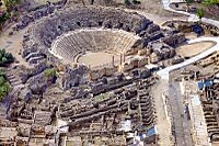
The Roman theatre
-
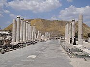
Roman cardo
-
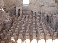
Roman baths


Byzantine Era (Christian City)

Many old remains from the Byzantine Empire (330-636 AD) have been found. A round church was built on top of the mound. The whole city was surrounded by a wall. Scythopolis was mostly Christian, with many churches. But there were also Jewish and Samaritan communities.
Many colorful mosaics were found. One mosaic shows the zodiac signs. Another from a synagogue has a temple menorah and the word shalom (peace). The Samaritan synagogue had unique mosaics with only plants and shapes, no people or animals. The city grew very large in the 6th century, with about 40,000 people.
Early Muslim Period
In 634 AD, the Byzantine forces were defeated by the Rashidun army. The city went back to its old name, Baysan, in Arabic. The city was not damaged. Muslims and Christians lived together until the 8th century.
The city declined over time. Streets became narrow alleys. Marble was taken from buildings to make lime. A main plaza became a cemetery. However, some new discoveries show that the market street was rebuilt around 720 AD.
On January 18, 749, a huge earthquake destroyed Baysan. Some people built homes among the ruins, but the city never became grand again. The city center moved to a southern hill.
In 985 AD, a historian visited Baysan. He wrote that it had many palm trees and water. He also noted that Baysan was known for its indigo, rice, dates, and grape syrup.
Crusader and Mamluk Periods

During the Crusader period, the Crusaders built a small fortress in the area southeast of the Roman theater. This was where the smaller town had moved after the earthquake. Saladin destroyed this fortress in 1183.
Under Mamluk rule, Beit She'an was an important town. It was a stop for the postal service between Damascus and Cairo. It was also a center for making sugar cane products. A bridge with a single arch, called Jisr al-Maqtu'a, was built then.
Ottoman Rule and British Mandate

For 400 years under Ottoman rule, Baysan lost its importance. A small revival happened when the Jezreel Valley railway was built in the early 1900s. Most local farmers were poor because of the Ottoman land system.
In the early 20th century, Baysan was a small village. But it was known for its good water supply and fertile soil. It produced olives, grapes, figs, and other fruits.

Under the British Mandate, Beit She'an was the center of its district. In 1922, it had about 1,941 people. Most were Muslims, with some Christians and Jews.
In 1938, after a Jewish leader was killed, Orde Wingate led an attack in the Arab part of Baysan. The 1947 UN Partition Plan suggested Beit She'an should be part of the Jewish state.
Modern Beit She'an

After Israel's Declaration of Independence in May 1948, the Arab residents left. The town was then settled by Jewish immigrants. For some years, the town faced challenges from nearby conflicts.
In 1999, Beit She'an officially became a city. It is in the middle of the Emek HaMaayanot Regional Council. David Levy, a well-known Israeli politician, came from Beit She'an.
Archaeology and Tourism

The University of Pennsylvania dug up ancient Beit She'an from 1921 to 1933. They found items from the Egyptian period. Many of these are now in the Rockefeller Museum in Jerusalem. Others are in the University of Pennsylvania Museum in Philadelphia.
More digs started in 1983 and continued until 1996. These digs found 18 different ancient towns built one after another. Ancient Beit She'an is now a major tourist spot. It shows amazing Roman and Byzantine ruins. The 7th-century Mosaic of Rehob was found by farmers. It has details about Jewish religious laws.
Earthquakes
Beit She'an is located near a major fault line called the Dead Sea Transform. This means it is one of the cities in Israel most at risk from earthquakes. Historically, a big earthquake destroyed the city in 749 AD.
Population and Economy
According to the Israel Central Bureau of Statistics, Beit She'an had about 17,704 people at the end of 2017. Most of the people are Jewish.
Beit She'an is a center for growing cotton. Many people work in the cotton fields of nearby farms. Other local jobs are in textile and clothing factories.
When the ancient city of Beit She'an became a national park in the 1990s, tourism grew a lot. It is now a big part of the town's economy.
Transportation

Beit She'an had a railway station that opened in 1904. It was part of the Jezreel Valley railway. This station closed in 1948.
From 2011 to 2016, the railway was rebuilt. The new Beit She'an railway station opened in the same spot. Now, people can take trains from Beit She'an to Afula, Haifa, and other places. The station also handles freight trains.
Sports
The local football (soccer) club, Hapoel Beit She'an, played in the top league in the 1990s. It later closed down. Another club, Maccabi Beit She'an, plays in a lower league.
Notable People
- Jackie Levy (Mayor)
- David Levy (Politician)
- Orly Levy (Politician)
Twin Towns
Beit She'an is twinned with:
 Cleveland, United States (Since 2019)
Images for kids
-
Historic railway station, 1930s
-
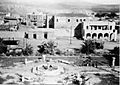
Beit She'an after conquest, 1948
-
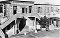
Ottoman Saray building used by Yiftach Brigade as company barracks, 1948
-
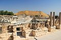
Beit Shean ruins
-
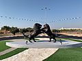
Lions playing sculpture, roundabout in Beit Shean
-
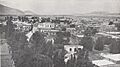
Beisan in 1936
-
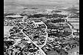
Beit She’an 1939
-
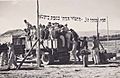
Pioneers of Kibbutz Ein Hanatziv settle in Bet She'an, 1946


See also
 In Spanish: Beit She'an para niños
