Campbell County, Kentucky facts for kids
Quick facts for kids
Campbell County
|
|
|---|---|

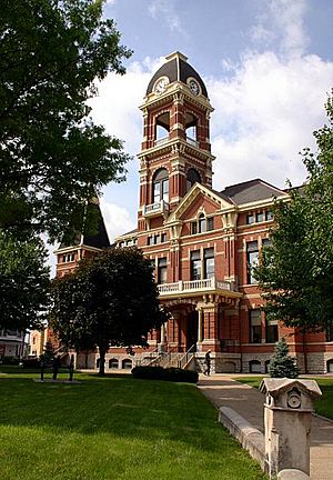
The Campbell County Courthouse in Newport
|
|

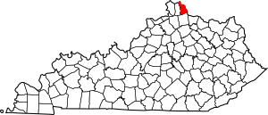
Location within the U.S. state of Kentucky
|
|
 Kentucky's location within the U.S. |
|
| Country | |
| State | |
| Founded | December 17, 1794 |
| Named for | John Campbell |
| Seat | Alexandria and Newport |
| Largest city | Fort Thomas |
| Area | |
| • Total | 159 sq mi (410 km2) |
| • Land | 151 sq mi (390 km2) |
| • Water | 8.1 sq mi (21 km2) 5.1%% |
| Population
(2020)
|
|
| • Total | 93,076 |
| • Estimate
(2023)
|
93,702 |
| • Density | 585.4/sq mi (226.0/km2) |
| Time zone | UTC−5 (Eastern) |
| • Summer (DST) | UTC−4 (EDT) |
| Congressional district | 4th |
Campbell County is a place in the northern part of Kentucky, a state in the United States. It's called a county, which is like a smaller area within a state. In 2020, about 93,076 people lived here.
The main towns where the county government works are called county seats. For Campbell County, these are Alexandria and Newport. The county was started on December 17, 1794. It was created from parts of other counties like Scott, Harrison, and Mason. Campbell County got its name from Colonel John Campbell. He was a soldier in the American Revolutionary War and also helped make laws for Kentucky.
Campbell County is part of a bigger area called Northern Kentucky. This area also includes Boone and Kenton Counties. It's also part of the larger Cincinnati-Middletown, OH-KY-IN Metropolitan Statistical Area.
Contents
History of Campbell County
Campbell County was formed on December 17, 1794. This was just two years after Kentucky became a state. It was the 19th county created in Kentucky. The county was made from land that used to be part of Scott, Harrison, and Mason counties.
When it was first created, Campbell County was much larger. It included all of what are now Boone, Kenton, and Pendleton counties. It also covered most of Bracken and Grant counties. The county was named after John Campbell. He was an Irish immigrant who was a soldier, explorer, and a lawmaker. He also helped write the first rules for Kentucky.
The first building for the county government, called a courthouse, was made of logs. In 1815, a new courthouse was built from bricks. The courthouse building used today was built in 1884.
Where the County Seat Has Been
The very first county seat for Campbell County was a settlement called Wilmington. This was from 1794 until 1797. After that, Newport became the county seat. But in 1823, the county seat was moved to Visalia. This was because Visalia was closer to the middle of the county at the time.
However, most people lived in the northern part of the county, near the Ohio River. So, moving the county seat to Visalia was not popular. The county government moved back to Newport in 1824 and stayed there until 1840.
In 1840, a new county called Kenton County was created. This new county took a large part of Campbell County's land. Because Campbell County was now smaller, the state government decided to move its county seat again. This time, it moved to Alexandria, which was closer to the center of the new, smaller Campbell County.
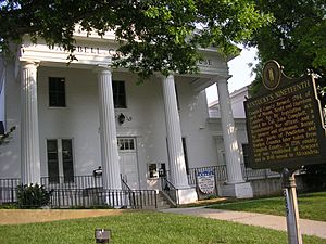
For many years, people from Newport wanted their city to be a county seat again. In 1883, a special law was passed. This law allowed Newport to have its own courthouse offices, separate from Alexandria. For a long time, people thought this meant the county had two county seats. But legally, Alexandria was still the only official county seat. It wasn't until November 24, 2010, that a court officially made Newport an equal county seat alongside Alexandria.
Geography of Campbell County
Campbell County covers about 159 square miles. Most of this area, about 151 square miles, is land. The rest, about 8.1 square miles, is water. This means about 5.1% of the county is water. Campbell County is one of the smallest counties in Kentucky. It is located along the Ohio River and the Licking River.
Neighboring Counties
Campbell County shares its borders with several other counties:
- Hamilton County, Ohio (to the north)
- Clermont County, Ohio (to the east)
- Pendleton County (to the south)
- Kenton County (to the west)
Main Roads
 I-275
I-275 I-471
I-471 US 27
US 27 KY 8
KY 8 KY 9
KY 9 KY 10
KY 10 KY 154
 KY 536
 KY 547
 KY 824
 KY 915
 KY 1120
 KY 1121
 KY 1566
 KY 1632
 KY 1936
 KY 1996
 KY 1997
 KY 1998
 KY 2345
 KY 2376
 KY 2828
 KY 2921
 KY 2924
People in Campbell County
| Historical population | |||
|---|---|---|---|
| Census | Pop. | %± | |
| 1800 | 1,903 | — | |
| 1810 | 3,473 | 82.5% | |
| 1820 | 7,022 | 102.2% | |
| 1830 | 9,883 | 40.7% | |
| 1840 | 5,214 | −47.2% | |
| 1850 | 13,127 | 151.8% | |
| 1860 | 20,909 | 59.3% | |
| 1870 | 27,406 | 31.1% | |
| 1880 | 37,440 | 36.6% | |
| 1890 | 44,208 | 18.1% | |
| 1900 | 54,223 | 22.7% | |
| 1910 | 59,369 | 9.5% | |
| 1920 | 61,868 | 4.2% | |
| 1930 | 73,391 | 18.6% | |
| 1940 | 71,918 | −2.0% | |
| 1950 | 76,196 | 5.9% | |
| 1960 | 86,803 | 13.9% | |
| 1970 | 88,704 | 2.2% | |
| 1980 | 83,317 | −6.1% | |
| 1990 | 83,866 | 0.7% | |
| 2000 | 88,616 | 5.7% | |
| 2010 | 90,336 | 1.9% | |
| 2020 | 93,076 | 3.0% | |
| 2023 (est.) | 93,702 | 3.7% | |
| U.S. Decennial Census 1790-1960 1900-1990 1990-2000 2010-2020 |
|||
In 2000, there were 88,616 people living in Campbell County. The population density was about 585 people per square mile. Most people living in the county were White (96.64%). There were also smaller groups of Black or African American people (1.57%), Asian people (0.54%), and Native American people (0.17%). About 0.86% of the population were Hispanic or Latino.
The average age of people in the county was 35 years old. About 25.6% of the people were under 18 years old.
Education in Campbell County
There are six different school districts in Campbell County. These districts manage the public schools in different areas.
- Bellevue Independent Schools, Bellevue
- Campbell County Schools, Alexandria
- Dayton Independent Schools, Dayton
- Fort Thomas Independent Schools, Fort Thomas
- Newport Independent Schools, Newport
- Southgate Independent School District (which has one school for PreK-8th grade)
A former school district, Silver Grove Independent Schools, joined with the Campbell County district on July 1, 2019.
For higher education, Northern Kentucky University is located in Highland Heights.
Public High Schools
Students in Campbell County can attend one of six public high schools.
Private High Schools
There are also two private high schools in the county, which are part of the Roman Catholic Diocese of Covington:
- Bishop Brossart High School, Alexandria
- Newport Central Catholic High School, Newport
Communities in Campbell County
Cities
- Alexandria (one of the county seats)
- Bellevue
- California
- Cold Spring
- Crestview
- Dayton
- Fort Thomas
- Highland Heights
- Melbourne
- Mentor
- Newport (one of the county seats)
- Silver Grove
- Southgate
- Wilder
- Woodlawn
Census-Designated Place
- Claryville (This is a community that is not officially a city, but the U.S. Census Bureau counts its population.)
Other Unincorporated Places
These are smaller communities that are not officially cities or census-designated places.
- Brayville
- Camp Springs
- Oneonta - This place was likely named after Oneonta, New York. It was a convenient spot along the Ohio River for boats to stop and pick up people and supplies. It was especially useful for travel from New Richmond, Ohio to Alexandria, Kentucky.
See also
 In Spanish: Condado de Campbell (Kentucky) para niños
 | Frances Mary Albrier |
 | Whitney Young |
 | Muhammad Ali |


