
Charlottesville, Virginia facts for kids
Quick facts for kids
Charlottesville, Virginia
|
||
|---|---|---|

Charlottesville Downtown Mall
|
||
|
||
| Nicknames:
C'ville, Hoo-Ville
|
||
| Motto(s):
A great place to live for all of our citizens.
|
||

Charlottesville, Virginia
Location in Virginia

Charlottesville, Virginia
Location in the United States
|
||
| Country | United States | |
| State | Virginia | |
| County | None (Independent city) | |
| Founded | 1762 | |
| Named for | Charlotte of Mecklenburg-Strelitz | |
| Government | ||
| • Type | Council–manager | |
| Area | ||
| • Independent city | 10.27 sq mi (26.60 km2) | |
| • Land | 10.25 sq mi (26.55 km2) | |
| • Water | 0.02 sq mi (0.05 km2) | |
| Elevation | 594 ft (181 m) | |
| Population
(2020)
|
||
| • Independent city | 46,553 | |
| • Density | 4,541.76/sq mi (1,753.41/km2) | |
| • Metro | 221,524 (209th) | |
| Demonym(s) | Charlottesvillian | |
| Time zone | UTC−5 (EST) | |
| • Summer (DST) | UTC−4 (EDT) | |
| ZIP Codes |
22901–22908
|
|
| Area code(s) | 434 | |
| FIPS code | 51-14968 | |
| GNIS feature ID | 1498463 | |
| Major Roadways | ||
| Waterways | Rivanna River | |
| Public Transit | Charlottesville Area Transit, University Transit Service, JAUNT | |
| Rail Service | Cardinal, Crescent, Northeast Regional | |
| Airport | Charlottesville-Albemarle | |

Charlottesville, also known as C'ville, is an independent city in Virginia, United States. It is the main city of Albemarle County, even though they are separate legal places. The city was named after Queen Charlotte, who was the wife of King George III.
In 2020, about 46,553 people lived in Charlottesville. When you include Albemarle County, the population is around 160,000. Charlottesville is the center of a larger area that includes nearby counties like Fluvanna, Greene, and Nelson.
Charlottesville was once home to two U.S. presidents: Thomas Jefferson and James Monroe. The University of Virginia, started by Thomas Jefferson, is located right on the city's edge. Jefferson's famous home, Monticello, is also nearby. Both Monticello and the University of Virginia are UNESCO World Heritage Sites, which means they are very important historical places. Thousands of visitors come to see them every year!
Contents
- History of Charlottesville
- Geography and Climate
- People of Charlottesville
- Charlottesville's Economy
- Fun Things to Do and Culture
- Sports in Charlottesville
- Education in Charlottesville
- Media in Charlottesville
- Getting Around Charlottesville
- Famous People from Charlottesville
- Sister Cities
- Images for kids
- See also
History of Charlottesville
Before Europeans arrived, the area where Charlottesville now stands was home to a Monacan village called Monasukapanough.
Charlottesville was officially created in 1762. It was built along an important trade route called Three Notch'd Road, which connected Richmond to the Great Valley. The city was named after Charlotte of Mecklenburg-Strelitz, who was the queen of Great Britain at the time.

During the American Revolutionary War, some captured British and German soldiers were held in Charlottesville from 1779 to 1781. In 1781, a brave rider named Jack Jouett warned the Virginia government, who were meeting at Monticello, about an upcoming attack. This warning helped them escape safely.
Charlottesville was lucky during the American Civil War because it wasn't heavily damaged like many other parts of Virginia. There was only a small fight called the Battle of Rio Hill. The city's mayor gave up the city to prevent it from being burned down. A factory that made wool clothing for soldiers accidentally burned down in 1865 but was quickly rebuilt.
The first church for African Americans in Charlottesville was started in 1864. Before that, it was against the law for them to have their own churches. The oldest synagogue building still standing in Virginia, Congregation Beth Israel's, was built in 1882.
In 1958, Charlottesville closed its white-only schools for a short time. This was part of Virginia's plan to resist federal orders to end segregation (keeping races separate) in schools. However, schools for African American students stayed open.

Today, Charlottesville is home to important scientific and financial organizations. These include the National Radio Astronomy Observatory and the CFA Institute. The city also has two main hospitals: Martha Jefferson Hospital and the University of Virginia Hospital.
Other big employers in the area include the National Ground Intelligence Center (NGIC), Crutchfield, GE Intelligent Platforms, PepsiCo, and S&P Global.
Geography and Climate
Charlottesville covers about 10.3 square miles (26.6 square kilometers) of land. It is located in the middle of Virginia, along the Rivanna River. This river flows into the James River. The city is also near the Southwest Mountains and about 20 miles (32 km) from the Blue Ridge Mountains.
Charlottesville is about 115 miles (185 km) from Washington, D.C. and 70 miles (113 km) from Richmond.

Charlottesville's Weather
Charlottesville has four different seasons. It gets plenty of rain all year, but especially from May to September. Winters are cool, with January temperatures averaging around 35.9°F (2.2°C). It can get very cold some nights. Summers are hot and humid, with July temperatures averaging 77.2°F (25.1°C). It often gets hotter than 90°F (32°C) in the summer. Snowfall changes a lot each year but is usually light, averaging about 17.3 inches (44 cm). The snow doesn't usually stay on the ground for a long time.
| Climate data for Charlottesville, Virginia (1981–2010 normals) | |||||||||||||
|---|---|---|---|---|---|---|---|---|---|---|---|---|---|
| Month | Jan | Feb | Mar | Apr | May | Jun | Jul | Aug | Sep | Oct | Nov | Dec | Year |
| Mean daily maximum °F (°C) | 45.2 (7.3) |
49.2 (9.6) |
57.6 (14.2) |
68.7 (20.4) |
75.7 (24.3) |
84.0 (28.9) |
87.5 (30.8) |
86.0 (30.0) |
79.3 (26.3) |
68.9 (20.5) |
59.0 (15.0) |
47.8 (8.8) |
67.4 (19.7) |
| Mean daily minimum °F (°C) | 26.6 (−3.0) |
29.0 (−1.7) |
36.0 (2.2) |
45.6 (7.6) |
54.4 (12.4) |
63.2 (17.3) |
66.9 (19.4) |
65.4 (18.6) |
58.3 (14.6) |
47.8 (8.8) |
38.8 (3.8) |
29.9 (−1.2) |
46.8 (8.2) |
| Average precipitation inches (mm) | 3.10 (79) |
3.18 (81) |
3.89 (99) |
3.34 (85) |
4.56 (116) |
4.16 (106) |
5.31 (135) |
4.04 (103) |
4.89 (124) |
3.81 (97) |
4.01 (102) |
3.31 (84) |
47.61 (1,209) |
| Average snowfall inches (cm) | 4.6 (12) |
5.7 (14) |
2.1 (5.3) |
.1 (0.25) |
0 (0) |
0 (0) |
0 (0) |
0 (0) |
0 (0) |
0 (0) |
.5 (1.3) |
4.2 (11) |
17.3 (44) |
| Average precipitation days (≥ 0.01 in) | 9.2 | 9.3 | 10.7 | 11.3 | 12.6 | 10.6 | 12.2 | 11.1 | 9.7 | 8.3 | 8.9 | 9.6 | 123.6 |
| Average snowy days (≥ 0.1 in) | 2.1 | 2.2 | .8 | .1 | 0 | 0 | 0 | 0 | 0 | 0 | .3 | 1.5 | 7.0 |
| Source: NOAA | |||||||||||||
People of Charlottesville
| Historical population | |||
|---|---|---|---|
| Census | Pop. | %± | |
| 1870 | 2,838 | — | |
| 1880 | 2,676 | −5.7% | |
| 1890 | 5,591 | 108.9% | |
| 1900 | 6,449 | 15.3% | |
| 1910 | 6,765 | 4.9% | |
| 1920 | 10,688 | 58.0% | |
| 1930 | 15,245 | 42.6% | |
| 1940 | 19,400 | 27.3% | |
| 1950 | 25,969 | 33.9% | |
| 1960 | 29,427 | 13.3% | |
| 1970 | 38,880 | 32.1% | |
| 1980 | 39,916 | 2.7% | |
| 1990 | 40,341 | 1.1% | |
| 2000 | 40,099 | −0.6% | |
| 2010 | 43,475 | 8.4% | |
| 2020 | 46,553 | 7.1% | |
| 2021 (est.) | 45,672 | 5.1% | |
| U.S. Decennial Census 1790–1960 1900–1990 1990–2000 2010–2015 2020 |
|||
Population in 2020
| Race / Ethnicity | Pop 2010 | Pop 2020 | % 2010 | % 2020 |
|---|---|---|---|---|
| White alone (NH) | 28,827 | 29,609 | 66.31% | 63.60% |
| Black or African American alone (NH) | 8,344 | 7,030 | 19.19% | 15.10% |
| Native American or Alaska Native alone (NH) | 65 | 66 | 0.15% | 0.14% |
| Asian alone (NH) | 2,758 | 4,064 | 6.34% | 8.73% |
| Pacific Islander alone (NH) | 13 | 18 | 0.03% | 0.04% |
| Some Other Race alone (NH) | 89 | 218 | 0.20% | 0.47% |
| Mixed Race/Multi-Racial (NH) | 1,156 | 2,341 | 2.66% | 5.03% |
| Hispanic or Latino (any race) | 2,223 | 3,207 | 5.11% | 6.89% |
| Total | 43,475 | 46,553 | 100.00% | 100.00% |
Note: the US Census treats Hispanic/Latino as an ethnic category. This table excludes Latinos from the racial categories and assigns them to a separate category. Hispanics/Latinos can be of any race.
Population in 2010
In 2010, Charlottesville had 43,475 people living in 17,778 households. The city had about 4,220 people per square mile. Most people were White (69.1%), followed by Black (19.4%), Asian (6.4%), and other groups. About 5.1% of the population was Hispanic or Latino.
Many young people live in Charlottesville because of the University of Virginia. The average age was 27.8 years. About 27.3% of the population lived below the poverty line, including 15.8% of those under 18.
Charlottesville has many highly educated residents. About 20% of people living there have a graduate or professional degree. This is much higher than the national average of 10%.
Charlottesville's Economy

Charlottesville is a hub for many different types of businesses. It is home to the main offices of the National Radio Astronomy Observatory, which studies space, and the CFA Institute, which focuses on finance. The city also has two major hospitals: Martha Jefferson Hospital and the University of Virginia Hospital.
The National Ground Intelligence Center (NGIC) is located in the Charlottesville area. Other big companies that employ many people include Crutchfield, Emerson Automation Solutions, PepsiCo, and S&P Global.
Many people who work in Charlottesville actually live outside the city and travel in. About 82% of workers commute into Charlottesville, with 42% coming from Albemarle County. In 2016, the unemployment rate in Charlottesville was low, at 3.3%.
Top Employers in the City
Here are some of the largest employers in Charlottesville:
| # | Employer | # of employees |
|---|---|---|
| 1 | University of Virginia Medical Center | 1,000+ |
| 2 | City of Charlottesville | 1,000+ |
| 3 | UVA Health Services Foundation | 1,000+ |
| 4 | Charlottesville City School Board | 500–999 |
| 5 | Servicelink Management Com Inc | 500–999 |
| 6 | Aramark Campus LLC | 500–999 |
| 7 | WorldStrides (Lakeland Tours) | 500–999 |
| 8 | Association for Investment Management | 250-499 |
| 9 | RMC Events | 250-499 |
| 10 | Crutchfield Corporation | 250–499 |
Fun Things to Do and Culture


Charlottesville has many exciting places to visit and things to do, even though it's not a huge city. People come here for wine and beer tours, hot air balloon rides, hiking, and to see amazing shows. The famous Dave Matthews Band started here, and the city has a lively music scene. You can also enjoy performances by groups like the Blue Ridge Chamber Orchestra.
The Charlottesville area was home to three U.S. Presidents: Thomas Jefferson, James Madison, and James Monroe. You can visit Jefferson's plantation, Monticello, just a few miles from downtown. Monroe's home, Ash Lawn-Highland, is also nearby. Madison's home, Montpelier, is about 25 miles (40 km) northeast of the city.
The nearby Shenandoah National Park is a great place for outdoor activities. It has beautiful mountains and hiking trails. You can drive along Skyline Drive, which offers amazing views. The Blue Ridge Parkway, another scenic road, connects to Skyline Drive just 22 miles (35 km) west of Charlottesville.
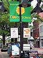
Charlottesville's downtown area is a busy place. It features the Downtown Mall, which is one of the longest outdoor walking malls in the country. Here you'll find shops, restaurants, theaters, and other fun spots. The historic Paramount Theater hosts Broadway shows and concerts. You can also visit the Virginia Discovery Museum and the Ting Pavilion, an outdoor amphitheater. Court Square, a few blocks away, is the oldest part of Charlottesville, with buildings from when the city was founded in 1762.
Charlottesville is also home to the University of Virginia. During the school year, over 20,000 students come to the city for the university. The main part of the university has Thomas Jefferson's famous Academical Village, with The Rotunda as its centerpiece. The University of Virginia Art Museum has a collection of over 10,000 art pieces.

The Corner is a lively area next to the University of Virginia. It's full of restaurants, shops, and places where students hang out. It gets very busy during football games and graduation ceremonies. West Main Street, which connects The Corner to the Downtown Mall, also has many restaurants and businesses.
Charlottesville hosts several annual events. These include the Virginia Film Festival in October, the Charlottesville Festival of the Photograph in June, and the Virginia Festival of the Book in March. The Foxfield Races, which are horse races, happen in April and September. Every Fourth of July, there's a celebration at Monticello.
Sports in Charlottesville

Charlottesville doesn't have professional sports teams, but it's home to the University of Virginia's athletic teams, called the Cavaliers. The Cavaliers are very popular in the region. They have teams in many sports, from soccer to basketball, and their modern facilities attract fans all year.
Football games at Scott Stadium draw the biggest crowds. This stadium has also hosted huge concerts by famous bands like the Dave Matthews Band, The Rolling Stones, and U2.
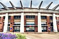
John Paul Jones Arena, which opened in 2006, is where the Cavalier basketball teams play. It also hosts concerts and other events. The arena can hold 14,593 people for basketball games. The Virginia men's basketball team won the NCAA championship in 2019!
Lacrosse is also very popular in Charlottesville. The Virginia Men's team has won seven NCAA Championships, with their most recent win in 2021. The Virginia Women's team has won three NCAA Championships. The soccer program is also strong, with the Men's team winning several NCAA Division I Championships. The Virginia baseball team won its first NCAA baseball title in 2015.
High school sports in the Charlottesville area are also very successful. Many local high schools have strong lacrosse teams. Charlottesville High School won the state boys' soccer championship in 2004 and again in 2019. Monticello High School won the state football title in 2007.
Charlottesville is also home to the Charlottesville Tom Sox, a baseball team that won league championships in 2017 and 2019. They play at Crutchfield Park.
Education in Charlottesville

The University of Virginia, a well-known public university, is located in Charlottesville and Albemarle County.
Piedmont Virginia Community College also has several locations in Charlottesville.
Charlottesville is served by the Charlottesville City Public Schools. The school system has six elementary schools, Walker Upper Elementary School, Buford Middle School, and Charlottesville High School. There are also several private schools in the city and nearby county that children from Charlottesville attend.
The Jefferson-Madison Regional Library provides library services to the people of Charlottesville.
Media in Charlottesville
Newspapers and Magazines
Charlottesville has a daily newspaper called The Daily Progress. There are also weekly newspapers like C-Ville Weekly and student newspapers like The Cavalier Daily from UVA. Many local magazines cover topics like homes, food, outdoor sports, and weddings.
TV and Radio
Charlottesville has local TV stations for major networks like NBC, PBS, CBS, FOX, and ABC. You can listen to news and talk radio on WINA 1070 and WCHV 1260. There are also stations for sports, country music, and National Public Radio. The University of Virginia owns a radio station, WTJU 91.1.
Getting Around Charlottesville
Roads and Highways
_in_Charlottesville,_Virginia.jpg)
The main highways that go through Charlottesville are Interstate 64 and U.S. Route 29. I-64 goes east towards Richmond and west towards Staunton. US 29 goes southwest towards Lynchburg and northeast towards Washington, D.C. Other important roads include U.S. Route 250 and Virginia State Route 20.
Public Transportation
.jpg)
Charlottesville has its own airport, Charlottesville-Albemarle Airport. You can also travel by train from the Charlottesville Amtrak Station or by bus from the Greyhound Lines terminal. Local bus service is provided by Charlottesville Area Transit, and the University Transit Service helps students get around the University of Virginia area.
Train Service
Amtrak, the national passenger train service, has three routes that stop in Charlottesville:
- The Cardinal travels between Chicago and New York City.
- Some Northeast Regional trains go between Boston and Roanoke.
- The Crescent travels between New York City and New Orleans.
Charlottesville used to be a very important train center. Two major railway companies, the Chesapeake and Ohio Railway (C&O) and the Southern Railway, had lines here. The place where their tracks crossed became a new train station called Union Station. This helped the local economy grow.
Today, Charlottesville Union Station is still used by Amtrak. The station was updated around 2000. There are also plans to extend Virginia Railway Express, a commuter train line, to Charlottesville in the future.
Famous People from Charlottesville
Many famous people have lived in Charlottesville throughout history. These include:
- Thomas Jefferson and James Monroe, who were U.S. Presidents.
- Writers like Edgar Allan Poe and William Faulkner.
- NFL player Ralph Horween.
- Movie stars like Rob Lowe, Sissy Spacek, Jessica Lange, and Sam Shepard.
- Novelist John Grisham.
- The Dave Matthews Band.
- The pop band Parachute.
- Billionaires John Kluge and Edgar Bronfman Sr..
Sister Cities
Charlottesville has four sister cities around the world. These partnerships help build friendships and understanding between different cultures:
 Besançon, France
 Pleven, Bulgaria
 Poggio a Caiano, Italy
 Winneba, Ghana
Images for kids
-
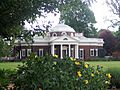
A view of Monticello from its gardens
-
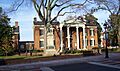
Historic Court Square
-
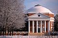
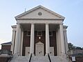
The Rotunda at the University of Virginia, designed by Thomas Jefferson
-
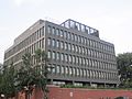
S&P Global building in Charlottesville
-
First United Methodist Church in the historic district of downtown Charlottesville (pictured July 2011) has since been renovated.
-
The Downtown Mall
-
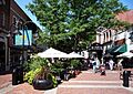
Downtown Mall
-
John Paul Jones Arena, home of the Virginia Cavaliers basketball programs
-
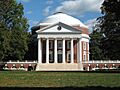
The Rotunda, situated on The Lawn in Charlottesville.
-
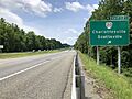
I-64 westbound at Exit 121 in Charlottesville
-
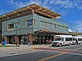
Bus Transit Center in downtown Charlottesville (2013)
See also
 In Spanish: Charlottesville para niños
