
Colorado River (Texas) facts for kids
Quick facts for kids Colorado River |
|
|---|---|

Colorado River in Austin as seen from Mount Bonnell
|
|

Map of the Colorado River and associated watershed
|
|
| Country | United States |
| State | Texas |
| Physical characteristics | |
| Main source | Dawson County 2,860 ft (870 m) 32°40′47″N 101°43′51″W / 32.67972°N 101.73083°W |
| River mouth | Matagorda Bay Gulf of Mexico, at Matagorda County, Texas 0 ft (0 m) 28°35′41″N 95°58′59″W / 28.59472°N 95.98306°W |
| Length | 862 mi (1,387 km) |
| Basin features | |
| Basin size | 39,900 sq mi (103,000 km2) |
The Colorado River in Texas is a really long river, about 862-mile-long (1,387 km)! It's the 11th longest river in the whole United States. What's cool is that it's the longest river that starts and ends entirely within Texas.
This river's drainage basin (the area of land where all the water flows into it) reaches into New Mexico. The river flows mostly southeast. It starts in Dawson County and passes through many towns. Some of these towns include Austin, Bastrop, and Bay City. Finally, it flows into the Gulf of Mexico at Matagorda Bay.
Contents
Where the River Flows

The Colorado River begins south of Lubbock. This is on a flat area called the Llano Estacado, near Lamesa. From there, it flows southeast. It goes through the beautiful Texas Hill Country.
Along its path, the river fills up several large lakes. These lakes are actually man-made reservoirs. Some of them include Lake J.B. Thomas, E.V. Spence Reservoir, and O.H. Ivie Lake. Before reaching Austin, it flows through even more lakes. These include Lake Buchanan, Inks Lake, Lake Lyndon B. Johnson (often called Lake LBJ), and Lake Travis.
Two other rivers join the Colorado River. The Llano River meets it at Lake LBJ. The Pedernales River joins at Lake Travis. After passing through Austin, the Colorado River keeps flowing southeast. It finally empties into Matagorda Bay in the Gulf of Mexico, near Matagorda.
River's History
The name "Colorado River" means 'red' or 'reddish' river in Spanish. Early Spanish explorers sometimes got this river mixed up with the Brazos River. The Brazos River is located to the north.
The first European explorer to find these rivers actually gave them opposite names. He called the river we know as the Colorado River the Brazos de Dios (Arms of God). He called the river we know as the Brazos River the Colorado River. Later, these names were switched around.
The upper part of the Colorado River was controlled by the Comanche people for a long time. This was from the early 1700s to the late 1800s. In 1757, Spanish Texas tried to build a Catholic mission there. It was called Mission Santa Cruz de San Sabá. This mission was near where the San Saba River meets the Colorado River.
The Comanche tribe saw this as an invasion of their land. The mission was not well protected. In 1758, about 2,000 Comanches and their friends attacked the mission. The Comanche were very strong in this area for almost 100 years.
How People Use the River
The Colorado River is very important for people in Texas. It provides water for many things. It supplies water for farming, for cities, and for making electrical power.
There are many important man-made lakes (reservoirs) on the river. These include Lake Buchanan, Inks Lake, Lake LBJ, Lake Marble Falls, Lake Travis, Lake Austin, and Lady Bird Lake in Austin. Together, these lakes are known as the Texas Highland Lakes.
Besides power plants at these lakes, the Colorado River's water is also used to cool the South Texas Nuclear Project. This is a power plant near Bay City. The Colorado River Municipal Water District also manages three reservoirs upstream. These are Lake J. B. Thomas, E.V. Spence Reservoir, and O.H. Ivie Lake.
Two special groups manage the river's water. They help control floods and make sure the water is used well. These groups are the Upper Colorado River Authority and the Lower Colorado River Authority. There are 11 major reservoirs along the Colorado River in total.
Main Rivers Joining the Colorado
The Colorado River has five main rivers that flow into it. These are called tributaries. They are the Concho River, Pecan Bayou, the Llano River, the San Saba River, and the Pedernales River.
Beals Creek is also a tributary. It gets its water from smaller streams called arroyos. Some of these arroyos include the Sulphur Springs Draw, the Johnson Draw, and others like McKenzie and Seminole draws.
Gallery
-
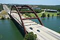
Pennybacker Bridge crossing the Lake Austin part of the Colorado River
-
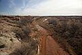
The Colorado River about 5 mi (8 km) from where it starts. This is near the border of Dawson and Borden County.
-
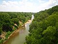
The Colorado River under the Regency Suspension Bridge on the border of Mills and San Saba County.
-
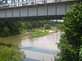
A scenic view of the Colorado River flowing under a bridge overpass in Wharton.
-
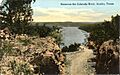
A scene on the Colorado River in Austin, Texas, from an old postcard (around 1907).
-
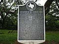
A historical marker explains how hard it was to travel on the lower Colorado River in the 1800s.
-
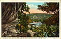
An old postcard of Bull Creek in Austin.
-
The Colorado River east of Columbus, Texas.
-
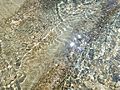
Water reflections at Sculpture Falls in the Austin Greenbelt.


.jpg)
See also
 In Spanish: Río Colorado (Texas) para niños
