Cypress Hills (Canada) facts for kids
Quick facts for kids Cypress Hills |
|
|---|---|

The Cypress Hills
|
|
| Highest point | |
| Elevation | 1,468 m (4,816 ft) |
| Geography | |
| Country | Canada |
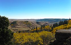
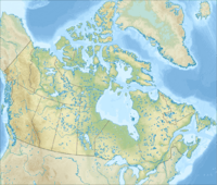
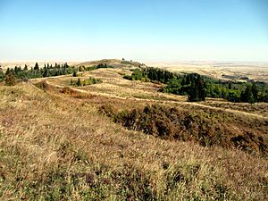
The Cypress Hills are a special group of hills in southwestern Saskatchewan and southeastern Alberta, Canada. They stand out because they are much higher than the flat lands around them.
The highest point in the Cypress Hills is called Head of the Mountain in Alberta. It reaches about 1,466 meters (4,810 feet) high. In Saskatchewan, the highest point is 1,392 meters (4,567 feet) high, located in a farmer's field.
Contents
What's in a Name?
The Cypress Hills have had many names over time, given by different groups of people. The Blackfoot people called them I-kim-e-kooy, which means "striped earth." The Cree name, manâtakâw, means "an area to be respected or taken care of." The Gros Ventre people called them θáaciih, meaning "pine trees."
Early Métis hunters, who spoke a kind of French, called the hills les montagnes des Cyprès. This was because there were many jack pine trees there. In their French, the jack pine was called cyprès, even though it's not a true cypress tree. When translated into English, this became Cypress Hills.
How the Hills Were Formed
The Cypress Hills rise about 600 meters (1,970 feet) above the surrounding plains. They are what's left of a much larger flat area that has been worn away by nature over millions of years.
Ancient Rivers and Fossils
The top of the hills is made of strong rock layers called conglomerate and sandstone. These rocks were laid down by ancient rivers that flowed from the mountains in Alberta and Montana a very long time ago. These rocks are famous for having lots of fossils of ancient animals.
Ice Age Survivors
During the Pleistocene Ice Age, huge sheets of ice covered much of North America. But the very top of the Cypress Hills was so high that it was never covered by this ice! It stayed like an island above the ice. As the ice melted and moved back, it left behind piles of rock and dirt called moraines around the hills. Melting water also carved out deep channels and unique landforms called badlands.
Water's Journey
Today, the Cypress Hills are like a giant split for water. Rain and snow that fall on the hills can flow in two different directions. Some water goes south towards the Gulf of Mexico through the Missouri River. Other water flows northeast to Hudson Bay through the Nelson River. There's even a special spring where water splits and goes both ways!
Nature and Wildlife
Because the Cypress Hills are higher up, they get cooler temperatures and more rain than the flat lands around them. This means they have different plants and animals, much like what you'd find in the mountains of Montana and Wyoming.
Plants of the Hills
The cooler, north-facing slopes and some valleys are home to forests of aspen, lodgepole pine, and white spruce trees. Other parts of the hills are covered in grasslands. You can find beautiful wildflowers like prairie crocus, lupine, and prairie rose. There are also fourteen types of orchids, including the pretty Venus's slipper orchid.
Animals of the Hills
The Cypress Hills are full of different animals! You might see small mammals like jackrabbits, skunks, and foxes. Larger animals include moose, elk, mule deer, and white-tailed deer. You might even spot coyotes, cougars, or black bears.
There are also several types of snakes, including the prairie rattlesnake, plus lizards and turtles. Many birds live here, from the colorful mountain bluebird to large birds of prey like the great horned owl. The lakes and streams have fish like walleye, yellow perch, and different kinds of trout.
History of the Hills
For a long time, the Cypress Hills were an important meeting place for many First Nations groups, including the Cree, Assiniboine, Blackfoot, and Sioux. It was also a place where different groups sometimes had conflicts.
The Cypress Hills Massacre
In the 1800s, Métis hunters also settled and hunted in the hills. A very important event in Canadian history, called the Cypress Hills Massacre, happened here. A group of American wolf hunters attacked an Assiniboine camp. This terrible event led to the creation of the North-West Mounted Police (who later became the Royal Canadian Mounted Police) to bring law and order to the border region. Fort Walsh was built to help keep the peace.
Cypress Hills Interprovincial Park
Today, a large part of the Cypress Hills is protected as the Cypress Hills Interprovincial Park. This park is special because it crosses the border between Saskatchewan and Alberta. The Saskatchewan side of the park has two main areas:
- The Centre Block has places for tourists to stay all year round.
- The West Block is a wilder area with simpler camping, and it's also where Fort Walsh is located.
On the Alberta side, you'll find Elkwater, a community with campgrounds and cabins by Elkwater Lake. It's a popular spot for summer vacations.
Weather in the Hills
The Cypress Hills have a cool climate, even though they are in the prairies. This is because they are so high up. Summers are mild to warm during the day, with cool nights. Winters are cold and get a lot of snow, about 255 cm (100 inches) each year!
The most rain falls in June, often with thunderstorms. Sometimes, warm winds called Chinook winds can make the temperature rise very quickly. It's not unusual for the temperature to jump from -10 °C (14 °F) to 20 °C (68 °F) in just 12 hours!
The most snow in one day was 60 cm (23.6 inches) on May 15, 1999. The highest temperature ever recorded was 40.5 °C (104.9 °F) on May 29, 1988. The lowest was -42.5 °C (-44.5 °F) on January 13, 2005.
| Climate data for Cypress Hills (1196m) | |||||||||||||
|---|---|---|---|---|---|---|---|---|---|---|---|---|---|
| Month | Jan | Feb | Mar | Apr | May | Jun | Jul | Aug | Sep | Oct | Nov | Dec | Year |
| Record high °C (°F) | 19.0 (66.2) |
18.0 (64.4) |
19.0 (66.2) |
26.0 (78.8) |
40.5 (104.9) |
34.0 (93.2) |
34.5 (94.1) |
34.5 (94.1) |
32.0 (89.6) |
28.0 (82.4) |
21.0 (69.8) |
15.0 (59.0) |
40.5 (104.9) |
| Mean daily maximum °C (°F) | −3.0 (26.6) |
−1.4 (29.5) |
2.4 (36.3) |
9.8 (49.6) |
15.2 (59.4) |
19.1 (66.4) |
23.2 (73.8) |
22.8 (73.0) |
16.6 (61.9) |
10.1 (50.2) |
1.7 (35.1) |
−2.3 (27.9) |
9.5 (49.1) |
| Daily mean °C (°F) | −9 (16) |
−7.2 (19.0) |
−2.9 (26.8) |
3.5 (38.3) |
8.7 (47.7) |
12.7 (54.9) |
15.9 (60.6) |
15.3 (59.5) |
9.6 (49.3) |
4.0 (39.2) |
−3.5 (25.7) |
−8.0 (17.6) |
3.3 (37.9) |
| Mean daily minimum °C (°F) | −15.0 (5.0) |
−13.0 (8.6) |
−8.2 (17.2) |
−2.9 (26.8) |
2.1 (35.8) |
6.3 (43.3) |
8.6 (47.5) |
7.6 (45.7) |
2.7 (36.9) |
−2.2 (28.0) |
−8.6 (16.5) |
−13.7 (7.3) |
−3.0 (26.6) |
| Record low °C (°F) | −42.5 (−44.5) |
−40.0 (−40.0) |
−35.5 (−31.9) |
−26.5 (−15.7) |
−11.5 (11.3) |
−3.5 (25.7) |
0.0 (32.0) |
−4.0 (24.8) |
−10.0 (14.0) |
−28.5 (−19.3) |
−39.0 (−38.2) |
−41.5 (−42.7) |
−42.5 (−44.5) |
| Average precipitation mm (inches) | 33.3 (1.31) |
31.0 (1.22) |
43.3 (1.70) |
41.4 (1.63) |
74.0 (2.91) |
103.3 (4.07) |
59.7 (2.35) |
47.8 (1.88) |
58.9 (2.32) |
36.8 (1.45) |
32.8 (1.29) |
38.3 (1.51) |
600.6 (23.64) |
| Source: Environment Canada | |||||||||||||
See also
 In Spanish: Montañas Cypress para niños
 | May Edward Chinn |
 | Rebecca Cole |
 | Alexa Canady |
 | Dorothy Lavinia Brown |


