
El Espinar facts for kids
Quick facts for kids
El Espinar
|
|||
|---|---|---|---|
 |
|||
|
|||

El Espinar
Location in Castile and León

El Espinar
Location in Spain
|
|||
| Country | Spain | ||
| Autonomous community | |||
| Province | |||
| Municipality | El Espinar | ||
| Area | |||
| • Total | 204 km2 (79 sq mi) | ||
| Population
(2018)
|
|||
| • Total | 9,061 | ||
| • Density | 44.42/km2 (115.04/sq mi) | ||
| Time zone | UTC+1 (CET) | ||
| • Summer (DST) | UTC+2 (CEST) | ||

.svg)
El Espinar is a town in Spain, about 65 kilometers (40 miles) from Madrid. It's located on the northern side of the Sistema Central mountain range. This town is part of the province of Segovia in the autonomous Community of Castile and León.
In 2023, about 9,814 people lived in El Espinar. The town is actually made up of four separate areas: El Espinar, San Rafael, La Estación de El Espinar, and Los Ángeles de San Rafael. El Espinar is the oldest and largest area, and it's where the main town hall is located.
Contents
- A Look at El Espinar's Past
- Nature and Weather in El Espinar
- Animals and Plants of El Espinar
- Getting Around El Espinar
- El Espinar's Economy
- How Many People Live in El Espinar?
- Sports in El Espinar
- Buildings and Town Layout
- Fun Events and Celebrations
- Community Groups
- El Espinar in Movies
- Gallery
- See also
A Look at El Espinar's Past
The story of El Espinar goes back a long way, even though written records only start in the 11th century. People lived here as early as the Iron Age. In 2016, an ancient settlement called Canto Los Hierros was found nearby. It was used during the Iron Age and later by the Romans. This settlement was huge, covering about 70 hectares (173 acres) and had around 100 houses! Finding such an old settlement so high up in the mountains is very rare in Europe.
Long ago, during the time of the Visigothic Kingdom, the town was called Gudillos. Later, when Al-Andalus ruled, it was known as Albarrana.
In 1293, El Espinar received an important document called the Carta Puebla. This document made the town independent from the city of Segovia. It was updated in 1317 and 1368, allowing the town to grow its land.
El Espinar played a part in the Revolt of the Comuneros. About 2,000 fighters from El Espinar joined the rebel leader Juan Bravo to help the rebels in Segovia.
In the 18th century, El Espinar grew a lot. This was partly because of sheep wool production. Also, a new, safer mountain pass called Guadarrama Pass became popular for travel between Madrid and northwestern Spain. This helped the town's economy.
In 1888, a railway line was built connecting Madrid and Segovia. This made it much faster to travel to El Espinar, which helped the town grow even more.
By the early 1900s, El Espinar became a popular summer spot for people from Madrid. It was a great place to escape the hot city summers. From 1936 to 1939, the area near the Guadarrama pass was an important battle line during the Spanish Civil War. Today, you can still find bunkers there, making it a popular spot for history buffs. In recent years, more people from Madrid have moved to El Espinar to live permanently, traveling to Madrid for work.
Nature and Weather in El Espinar
Where is El Espinar Located?

El Espinar is in the southern part of the Segovia province. Mountains of the Sistema Central surround it on the north, east, and south. Only the west and northwest areas are open to the lower lands of the northern plateau.
The land in El Espinar ranges from 2,197 meters (7,208 feet) high at La Pinareja mountain to 1,050 meters (3,445 feet) in the Moros valley. However, the areas where people live are usually between 1,100 and 1,200 meters (3,600 and 3,900 feet) above sea level.
On clear days, you can easily see the skyline of Madrid from the eastern mountains. From the western and northern mountains, you get a great view of the northern plateau. From the southwest, you can even see the Gredos mountains.
The three highest mountains in the area are La Pinareja (2,197 m), Peña del Oso (2,196 m), and Montón de Trigo (2,161 m), all in the northeast. Other peaks like Cueva Valiente (1,904 m) and Cabeza Líjar (1,824 m) are in the south. La Peñota (1,945 m) is in the east, and Caloco (1,567 m) is in the west.
Most of El Espinar is in the upper Moros valley. The Moros river flows into the Eresma, which then flows into the Duero. You can find beautiful natural swimming spots called La Panera along the Moros river in the pine forest. There are also over 180 drinkable water springs in the area.
What is El Espinar's Climate Like?
El Espinar has a mediterranean climate with strong influences from being in the center of Spain and at a high altitude. It's known as a Csb climate, which means it's temperate with dry summers.
Summer is the driest time of year. Any rain usually comes from thunderstorms in July and August. The rest of the year, rain is more common. Late autumn is the rainiest season, followed by mid-spring. Winters are a bit drier than autumn and spring, but not as dry as summer.
The amount of rain each year can vary a lot, from 400 to 1,000 mm (15 to 40 inches). Sometimes, droughts can last longer than just the summer months. Unlike lower areas, the grass in El Espinar often stays green until late May or even July because mid-spring is cooler and rainier. It turns green again from late September.
Snow can fall from late November to mid-April. Heavy snowfalls, with over 40 centimeters (16 inches) of snow, happen at least once every few years.
In mid-summer, daily high temperatures are usually between 27°C and 30°C (81-86°F). Nighttime lows are typically 12°C to 14°C (54-57°F). During very cold periods, temperatures can drop to -15°C (5°F). During heat waves, they can reach 36°C (97°F). If you're staying out at night in summer, you'll probably need a long-sleeved shirt!
Sometimes, during very cold spells, temperatures might stay below 0°C (32°F) all day. This usually happens if strong northern winds bring thick clouds.
| Climate data for El Espinar. Elevation: 1,237 m (4,058 ft). 1987 - 2022 normals. | |||||||||||||
|---|---|---|---|---|---|---|---|---|---|---|---|---|---|
| Month | Jan | Feb | Mar | Apr | May | Jun | Jul | Aug | Sep | Oct | Nov | Dec | Year |
| Daily mean °C (°F) | 2.6 (36.7) |
3.6 (38.5) |
6.0 (42.8) |
7.7 (45.9) |
11.9 (53.4) |
16.2 (61.2) |
19.5 (67.1) |
19.6 (67.3) |
15.5 (59.9) |
11.2 (52.2) |
5.9 (42.6) |
3.9 (39.0) |
10.3 (50.5) |
| Average precipitation mm (inches) | 66.0 (2.60) |
54.4 (2.14) |
58.9 (2.32) |
67.5 (2.66) |
66.5 (2.62) |
34.5 (1.36) |
17.5 (0.69) |
18.4 (0.72) |
37.7 (1.48) |
82.9 (3.26) |
94.7 (3.73) |
78.4 (3.09) |
677.4 (26.67) |
| Source: Aemet. El Espinar's wood company weather station. Weather data provided by Enrique Martín and José Enrique Martín that has been published in La Voz de El Espinar local newspaper. | |||||||||||||
Animals and Plants of El Espinar
The plants in El Espinar are mostly like those found in the Mediterranean. However, you can also find some deciduous trees (trees that lose their leaves in autumn).
The southern and eastern mountains are mostly covered with Scots Pine trees. The northern and western areas have fewer trees, with oaks forming open woodlands called dehesa, and also grasslands. Mountains above 1,900 meters (6,200 feet) have mostly shrubland because winters are harsh and long, and summers are short and dry. This prevents large trees from growing.
Below 1,200 meters (3,900 feet), you can find narrow forests of Populus alba (White Poplar) trees along the many streams in the area.
El Espinar is home to many animals, including roe deer, wild boar, badger, weasel, fox, Spanish imperial eagle, Eurasian black vulture, and the Graellsia Isabellae. White storks are common, building nests in pine forests, churches, and other buildings. Sometimes, if autumn and winter are warm, they don't fly to Africa. European cuckoos return every spring around mid-April and fly back to Africa from late July to mid-August. You can hear their beautiful song in the pine forest during their breeding season.
There are no dangerous animals, except for the Lataste's viper, but they only bite if they are greatly disturbed. Small groups of nomadic Iberian wolfs have been seen in recent years, especially in the western meadows of Campo Azálvaro. However, they usually avoid people and rarely come near towns.
There's a special center for spotting scavenger birds near the SG-500 road. The town is also known for collecting edible mushrooms, but you need to pay for a permit first.
Protected Natural Areas
A part of the northeastern mountains, about 1,082 hectares (2,674 acres), is inside the Guadarrama National Park. This means that 5.3% of the national park's area belongs to El Espinar. This protected area is the southwestern edge of the park.
Some of the western area, near Campo Azálvaro, is also a special protection area for birds.
Getting Around El Espinar
Roads

El Espinar has two toll motorways, AP-6 and AP-61, and two main roads, N-6 and N-603.
The AP-6 motorway connects Madrid to northwestern Spain. The toll only applies to a 35-kilometer (22-mile) section between the Guadarrama tunnel and Adanero. The AP-61 connects El Espinar to Segovia, a distance of 33 kilometers (20 miles). The N-6 and N-603 roads are alternative routes if you want to avoid the tolls.
Train
The town has a regular railway line connecting Madrid and Segovia (not the high-speed one). There are three train stops and one station in El Espinar: Gudillos, San Rafael, Estación de El Espinar, and Los Ángeles de San Rafael.
Local groups have asked for this railway line to be included in Madrid's commuter train system. Even though it's not officially part of it, the trains and services are similar to those in Madrid.
El Espinar doesn't have high-speed train stations. However, the closest ones are not too far: Guiomar, Chamartín, and Atocha.
Bus

There's a local bus called "La Carrula" that connects the four different areas of El Espinar.
Another bus route links El Espinar with both Segovia and the Moncloa transport hub in Madrid. These buses often go directly to the cities, but sometimes they stop in all the towns along the way. This bus service is run by a company called Avanza.
If you're traveling from Moncloa in Madrid to El Espinar, you need to go to the food court area, find the Avanza stand, buy your tickets, and then go to "isla 1" (island 1) to find docks eight and nine. The trip usually takes about 45 minutes. From Segovia to El Espinar, the bus ride is shorter, about 25 minutes, and the Segovia bus station is much smaller and less busy than Moncloa.
El Espinar's Economy
For centuries, El Espinar's economy relied on logging and the sheep wool industry. However, since the mid-20th century, most people work in the service sector (jobs like retail, tourism, healthcare). Food and aluminum industries have also become important since the late 20th century. There's a large industrial area called Polígono Los Llanos, located west of the El Espinar district.

How Many People Live in El Espinar?
| Year | Population |
|---|---|
| 1860 |
1,989
|
| 1900 |
2,087
|
| 1910 |
2,603
|
| 1920 |
3,006
|
| 1930 |
3,693
|
| 1940 |
3,744
|
| 1950 |
4,525
|
| 1960 |
4,772
|
| 1970 |
5,069
|
| 1981 |
4,968
|
| 1991 |
5,079
|
| 2001 |
6,293
|
| 2011 |
9,749
|
| 2021 |
9,476
|
| 2022 |
9,662
|
| 2023 |
9,814
|
Sports in El Espinar
El Espinar has teams in many popular sports, like football, five-a-side football, basketball, handball, cycling, equestrian sports, and golf. Football is the most popular, with several teams, including female football teams. Hiking is also very popular because there are many trails around.
Since 1986, El Espinar has hosted the Open Castilla y León international tennis tournament every July.
There's also a nine-hole golf course located west of town. Sometimes, the famous Atlético Madrid football team trains in Los Ángeles de San Rafael, one of El Espinar's districts.
Besides the natural swimming pool by the Moros river, there are two outdoor swimming pools and one indoor swimming pool with a gym and sauna. The outdoor pools are usually open from late June to early September.
Buildings and Town Layout
Each of the four districts of El Espinar has its own unique look:
El Espinar District

The oldest part of this district has houses that are usually one or two floors high. Some have been updated to three floors. Newer neighborhoods built in the 20th century have four-story buildings. However, many modern areas have semi-detached houses and individual houses with private gardens, especially in the eastern and southern parts.
The tallest and most important building is the San Eutropio church, which is about 18 meters (59 feet) tall. It's a late Gothic church with some Renaissance style, built in the shape of a Latin cross. There's also a lovely park called Parque Cipriano Geromini, perfect for shade in the summer.
San Rafael District

San Rafael started around 1790. It became popular in the late 1800s and early 1900s when people from Madrid built independent houses with gardens. Some of these houses were built in a traditional Swiss style, and you can still see many of them today. Because of its mountain feel, nature, and climate, San Rafael is often called "The Spanish Switzerland." The district has grown with some four-story apartment buildings, but individual and semi-detached houses are still the most common.
The tallest building here is the San Rafael church, about 12 meters (39 feet) tall.
La Estación de El Espinar District

This district began in 1888 when the railway line between Segovia and Madrid was built. It has mostly grown on the eastern side of the railway with individual houses. There are very few semi-detached houses or flats, and no flats are taller than two floors, so it's not very crowded. Even the San Antonio church is quite short, so there aren't many tall landmarks here.
Los Ángeles de San Rafael District

This is the newest district, started in 1967 near the N-603 road. It then expanded westwards and downhill towards the Moros river. It has three apartment buildings, each with eight floors and about 28 meters (92 feet) tall. These are the tallest buildings in all of El Espinar. It's the largest district in terms of land area, but not the most populated.
Fun Events and Celebrations
Each of El Espinar's four districts has its own special events and parties:
El Espinar District
- The most famous local festivity is El Cristo del Caloco. It's celebrated for eight days in early September, starting on the second weekend of the month.
- The second most popular festivities happen in mid-August, usually lasting three or four days.
- The Gabarreros festivity (Fiesta de los Gabarreros) is also important. It's held in mid-March and involves cutting down a pine tree in the main square. This event celebrates the old tradition of forestry workers who used to cut down pine trees and carry them with donkeys.
- Saint Patrick's Day has been celebrated here since 2018. It includes live music and people often wear green clothes. It's one of the biggest Saint Patrick's events in central Spain outside of big cities. Unlike in Ireland, it's not a religious event here.
- The Vikings event (Hispania de Los Vikingos) takes place in early April. It's a modern Viking recreation with exhibitions and fun outdoor activities. In 2023, over 8,000 people from Spain and other European countries attended!
- In early December, a Christmas Market is held in La Corredera square. It's the largest one in the entire Segovia province.
- The district also has a concert hall that hosts concerts and performances almost every weekend. It's the biggest in Segovia province and can seat about 400 people.
San Rafael District
- The patron saint's day is on September 29. Until 2011, this was the main seven-day festivity. But after a referendum, most people chose to move the main celebration to late July. This was because late September used to be rainy and cold at night, which often spoiled outdoor activities.
- The Gabarreros festivity is also celebrated in mid-March in Plaza Castilla square.
- Around mid-August, a craft and flea market is held in Plaza Castilla square.
- Every December 31st, in the early afternoon, some people gather for a quick swim in the very cold Gudillos river, just below the AP-6 motorway viaduct.
La Estación de El Espinar District
- The festivity of El Carmen takes place in mid-July.
- The street music festival of Femuka is held here every year in mid-June.
Los Ángeles de San Rafael District
- This district is the newest, with the first houses built in the late 1960s. So, it doesn't have old traditions or deep-rooted festivities. However, this district also has its own festivities in late August.
Community Groups
Some notable community groups include Felinar, a charity for stray cats; Yedra, which supports women's rights; Interampas, a parent-student association; and Hesperides, a citizen science group.
El Espinar in Movies
El Espinar has often been used as a filming location since 1960. This is because it has beautiful natural scenery and is quite close to the Madrid area.
Some well-known films and series mostly or entirely filmed here include:
- El Laberinto del Fauno (Pan's Labyrinth)
- Historias Lamentables
- El Ministerio del Tiempo (The Ministry of Time)
- Los Favoritos de Midas (The Minions of Midas)
- Las Chicas del Cable (Cable Girls)
- La Influencia
Many other films, TV series, and commercials have also been filmed in El Espinar.
Gallery
-
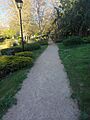
El Cordel park in San Rafael.
-
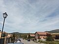
Panoramic view of the highrises of Los Ángeles de San Rafael in the far distance from La Estación de El Espinar.
-
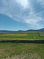
Green meadow in late spring.


See also
 In Spanish: El Espinar para niños
