
Galápagos Islands facts for kids
,_Punta_Pitt,_isla_de_San_Crist%C3%B3bal,_islas_Gal%C3%A1pagos,_Ecuador,_2015-07-24,_DD_11.JPG)
Galapagos sea lion on San Cristóbal Island
|
|
 |
|
| Geography | |
|---|---|
| Location | Pacific Ocean |
| Coordinates | 0°30′S 90°30′W / 0.500°S 90.500°W |
| Total islands | 127 |
| Major islands | 18 |
| Area | 7,880 km2 (3,040 sq mi) |
| Highest elevation | 1,707 m (5,600 ft) |
| Highest point | Volcán Wolf |
| Administration | |
| Province | Galápagos |
| Capital city | Puerto Baquerizo Moreno |
| Demographics | |
| Population | 33,042 (2020) |
| Pop. density | 3 /km2 (8 /sq mi) |
| Additional information | |
| Time zone |
|
| Official name: Galápagos Islands | |
| Type: | Natural |
| Criteria: | vii, viii, ix, x |
| Designated: | 1978 (2nd session) |
| Reference #: | 1 |
| Region: | South America |
| Extension: | 2001 and 2003 |
| Endangered: | 2007–2010 |


The Galápagos Islands (Spanish: Islas Galápagos) are a group of volcanic islands in the Eastern Pacific. They are located about 900 kilometers (560 miles) west of South America. These islands are part of the Galápagos Province of Ecuador. In 2020, about 33,000 people lived there.
The province is split into three areas called cantons: San Cristóbal, Santa Cruz, and Isabela. These are the three most populated islands. The Galápagos are famous for their many unique animals and plants found nowhere else. Charles Darwin studied these species in the 1830s. His observations helped him develop his theory of evolution by natural selection. All these islands are protected as part of Ecuador's Galápagos National Park and Marine Reserve.
It is not certain if people from Polynesia or South America visited the islands before Europeans. Bishop Tomás de Berlanga accidentally found the islands in 1535. If anyone did visit, the lack of fresh water likely stopped them from settling. The Spanish Empire did not pay much attention to the islands either. However, during the time of pirates, the Galápagos were a base for attacking Spanish ships. Goats and rats brought by pirates caused a lot of damage to the island's natural environment.
English sailors were important for exploring and mapping the area. Charles Darwin's trip on HMS Beagle was part of a big British survey of South America's coasts. Ecuador became independent from Spain in 1822 and claimed the islands on February 12, 1832. This was while Darwin's voyage was still happening. José de Villamil, who started the Ecuadorian Navy, led the effort to settle the islands. He slowly replaced the English names of the main islands with Spanish ones.
The United States built the first airport on the islands in the 1930s. This airport was a base to protect the Panama Canal. After World War II, Ecuador took over these facilities. Today, ecotourism is very important to the local economy. The airport was updated in the 2010s using recycled materials. It now runs completely on renewable energy to handle its many visitors.
Contents
- Island Names and Their Meanings
- How the Galápagos Islands Were Formed
- Where the Galápagos Islands Are Located
- Galápagos Climate and Weather
- Amazing Animals and Plants of Galápagos
- History of the Galápagos Islands
- Government and People
- Visiting the Galápagos Islands
- Protecting the Galápagos Environment
- Images for kids
- See also
Island Names and Their Meanings
The Galápagos Islands get their name from their giant tortoises. These tortoises were much more common when the islands were first found. The Spanish word galápago means "turtle" in most Spanish dialects. In Ecuadorian Spanish, it also describes the islands' large tortoises.
The islands were also called the Enchanted Isles because sailors found it hard to navigate around them. This was due to the tricky winds and currents. After Ecuador took over in 1832, they were sometimes called the Ecuador Archipelago. In 1892, they were named the Colon Archipelago to honor Christopher Columbus.
English sailors like Ambrose Cowley (in 1684) and James Colnett (in 1793) mapped the islands. They gave many islands English names to honor British royalty and naval officers. These names were used for a long time. Today, the official Spanish names have mostly replaced the English ones for the main islands.
How the Galápagos Islands Were Formed


The Galápagos Islands have had volcanoes erupting for at least 20 million years. A hot spot deep under the Earth's surface causes this volcanic activity. This hot spot is under the Nazca Plate, which is a huge piece of the Earth's crust. This plate moves eastward.
The Galápagos Islands have many volcanoes erupting at the same time. Some get their magma (melted rock) from deep within the Earth. Others get it from closer to the surface. The islands of Fernandina and Isabela are lined up along cracks in the Earth's crust. These cracks were caused by the spreading of the seafloor to the north.
The volcanoes on the islands are tall and rounded. This is different from the wide, smooth volcanoes in Hawaii. Isabela Island has six major volcanoes. These include Ecuador, Wolf, Darwin, Alcedo, Sierra Negra, and Cerro Azul. Eruptions on these volcanoes have happened from 1813 to 2008. Overall, the nine active volcanoes have erupted 24 times between 1961 and 2011.
The islands get older as you move from west to east. Fernandina is the youngest at about 0.05 million years old. San Cristobal is the oldest at about 3.2 million years old. The western volcanoes are generally taller and younger. They also have large calderas (bowl-shaped hollows at the top). The eastern islands are older, shorter, and do not have calderas.
Where the Galápagos Islands Are Located

The islands are in the eastern Pacific Ocean. They are about 973 kilometers (605 miles) off the west coast of South America. The closest land is mainland Ecuador, which is about 926 kilometers (575 miles) to the east.
The islands are located around the Equator. This means some islands are in the Northern Hemisphere and some are in the Southern Hemisphere. For example, Volcán Wolf and Volcán Ecuador on Isabela Island are directly on the equator. The islands stretch over a distance of 220 kilometers (137 miles).
The Galápagos Archipelago covers a land area of 7,880 square kilometers (3,042 square miles). This land is spread out over 45,000 square kilometers (17,000 square miles) of ocean. Isabela is the largest island, covering almost three-quarters of the total land area. Volcán Wolf on Isabela is the highest point, reaching 1,707 meters (5,600 feet) above sea level.
The group includes 18 main islands, 3 smaller islands, and 107 rocks and tiny islets. The islands sit on the Nazca Plate, which moves east/southeast. This plate is diving under the South American Plate. The first islands formed here at least 8 million years ago. The youngest islands, Isabela and Fernandina, are still forming today.
In April 2009, lava from Fernandina Island's volcano flowed towards the sea. In June 2018, Sierra Negra volcano on Isabela erupted for the first time since 2005. Lava flows reached the coast. This caused about fifty people to be moved and limited tourist access.
Main Islands of the Galápagos

There are 18 main islands in the Galápagos. Each has a land area of at least 1 square kilometer (0.4 square miles). Here are some of them:
- Baltra (South Seymour) Island – Baltra is a small, flat island. It was formed by the Earth's crust lifting up. The island is very dry. It has salt bushes, prickly pear cacti, and palo santo trees. Baltra has one of the two airports that receive flights from mainland Ecuador. In the 1940s, 70 land iguanas from Baltra were moved to nearby North Seymour Island. This helped save the species when the native iguanas on Baltra died out during World War II. Later, iguanas were brought back to Baltra.
- Bartolomé (Bartholomew) Island – This is a volcanic islet near Santiago Island. It is one of the younger islands. It is named after Bartholomew Sulivan, a friend of Charles Darwin. This island is home to the Galápagos penguin, the only wild penguin species living on the equator. Green turtles also live here.
- Darwin (Culpepper) Island – Named after Charles Darwin, this island is 1.1 square kilometers (0.4 square miles) in area. It has a maximum height of 168 meters (551 feet). You can see fur seals, frigates, marine iguanas, and various boobies here. Darwin's Arch, a natural rock arch, was near this island but collapsed in 2021.
- Española (Hood) Island – Named in honor of Spain, this island is 60 square kilometers (23 square miles). It is about 3.5 million years old, making it the oldest island. Española has many unique species because it is so far away from other islands. It has its own types of lava lizard, mockingbird, and Galápagos tortoise. The waved albatross nests only on Española.
- Fernandina (Narborough) Island – This island is named after King Ferdinand II of Aragon. It is 642 square kilometers (248 square miles) and is the youngest and westernmost island. On May 13, 2005, a new eruption began here. Hundreds of marine iguanas gather at Punta Espinosa. Famous flightless cormorants live on this island, along with penguins and sea lions.
- Floreana (Charles or Santa María) Island – Named after Juan José Flores, the first President of Ecuador. It is 173 square kilometers (67 square miles). This island has an interesting human history and was one of the first to be settled. Flamingos and green sea turtles nest here. At Post Office Bay, 19th-century whalers used a wooden barrel as a post office.
- Genovesa (Tower) Island – Named after Genoa, Italy, Christopher Columbus's birthplace. It is 14 square kilometers (5.4 square miles). This island is known as "the bird island." You can see frigatebirds, swallow-tailed gulls (the only nocturnal gull), and many types of boobies.
- Isabela (Albemarle) Island – Named after Queen Isabella I of Castile. It is the largest island at 4,640 square kilometers (1,790 square miles). Its highest point is Volcán Wolf. The island's seahorse shape comes from six large volcanoes joining together. Many animals live here, including Galápagos penguins, flightless cormorants, and marine iguanas.
- Marchena (Bindloe) Island – Named after Fray Antonio Marchena. It is 130 square kilometers (50 square miles). Galapagos hawks and sea lions live here. It is also home to the Marchena lava lizard, which is found only on this island.
- North Seymour Island – Named after Lord Hugh Seymour. It is 1.9 square kilometers (0.73 square miles). This island has many blue-footed boobies and frigatebirds. It was formed by the Earth's crust lifting up.
- Pinzón (Duncan) Island – Named after the Pinzón brothers, who were captains of Columbus's ships. It is 18 square kilometers (6.9 square miles). It is home to giant Galápagos tortoises and Galápagos sea lions.
- Pinta (Louis) Island – Named after the Pinta caravel. It is 60 square kilometers (23 square miles). Sea lions, Galápagos hawks, and giant tortoises can be seen here. Pinta Island was home to Lonesome George, the last Pinta tortoise, who died in 2012.
- Rábida (Jervis) Island – Named after the convent where Columbus left his son. It is 4.95 square kilometers (1.91 square miles). The lava here is red due to high iron content. White-cheeked pintail ducks live in a saltwater lagoon.
- San Cristóbal (Chatham) Island – Named after Saint Christopher, the patron saint of sailors. It is 558 square kilometers (215 square miles). This was the first island Charles Darwin visited. It has frigatebirds, sea lions, and blue-footed boobies. The capital of Galápagos Province, Puerto Baquerizo Moreno, is on this island.
- Santa Cruz (Indefatigable) Island – Named after the Holy Cross. It is 986 square kilometers (381 square miles). Santa Cruz has the largest human population in the archipelago, in the town of Puerto Ayora. The Charles Darwin Research Station is located here. They have a tortoise breeding center.
- Santa Fe (Barrington) Island – Named after a city in Spain. It is 24 square kilometers (9.3 square miles). Santa Fe has large Opuntia cacti and Palo Santo trees. Santa Fe land iguanas are often seen here.
- Santiago (San Salvador, James) Island – Named after Saint James. It is 585 square kilometers (226 square miles). Marine iguanas, sea lions, and fur seals live here. Pigs and goats, which caused harm to native species, have been removed from this island.
- Wolf (Wenman) Island – Named after the German geologist Theodor Wolf. It is 1.3 square kilometers (0.50 square miles). Fur seals, frigatebirds, and sharks can be seen here. The vampire finch, which feeds on blood from other birds, is only found on this island.
Smaller Islands and Islets

- Daphne Major – A small island north of Santa Cruz. It is known for long-term studies of finch populations.
- South Plaza Island (Isla Plaza Sur) – Named after a former president of Ecuador. It is 0.13 square kilometers (0.050 square miles). The island has Opuntia cactus and Sesuvium plants. Iguanas (land, marine, and hybrids) are common here.
- North Plaza Island - This island is located north of South Plaza Island.
- Nameless Island – A small islet mainly used for scuba diving.
- Roca Redonda – An islet about 25 kilometers (16 miles) northwest of Isabela.
- Guy Fawkes Island - A small island group northwest of Santa Cruz. It is visited by scuba divers.
- Isla Beagle - A small, mostly uninhabited island near Santiago.
- Isla Caldwell - This island is near Floreana and is 3.06 kilometers (1.90 miles) long.
- Isla Campéon - Also known as Champion island, this islet is 1.64 kilometers (1.02 miles) long. It is a refuge for the Floreana mockingbird.
- Isla Watson - This small islet is one of many near Floreana Island.
- Enderby Island - Another place where the Floreana mockingbird lives.
- Gardner Island (Galapagos) - There are two places called Gardner Island in the Galápagos. One is near Española, and one is near Floreana.
- Mosqua Island - Mosquera is one of the smallest islands. It is between North Seymour and Baltra Islands. It has many coral reefs, making it great for snorkeling. Mosquera is also home to a large colony of sea lions.
- Tortuga Island - This island is shaped like a crescent. It is a collapsed volcano and a nesting place for seabirds.
- Isla Los Hermanos - A small island off Isabela Island.
- Isla Sombrero Chino - This island's name means "Chinese Hat." It is shaped like an old-fashioned Chinese hat.
- Daphne Minor - Very close to Daphne Major, both are tuff cones without trees.
- Las Tintoreras Islet - A group of seven small islets south of Puerto Villamil on Isabela.
- Leon Dormido - This island is off San Cristobal. Its name means "Sleeping Lion." Its two rocks rise 140 meters (450 feet) into the air.
- Isla Cowley - A very small island located off Isabela.
- Isla El Edén - Eden Island is a small piece of volcanic rock along Santa Cruz Island's northwest shore.
- Isla Albany - Albany Rock is a small, crescent-shaped islet northwest of Santiago Island.
- Isla Onslow - One of the many islands near Floreana.
- Corona Del Diablo - Also known as the Devil's Crown, this is a ring of uneven rocks near Floreana Island.
Galápagos Climate and Weather


Even though the islands are on the equator, the Humboldt Current brings cold water to them. This causes frequent drizzles for most of the year. The weather is often affected by El Niño events. These happen every 3 to 7 years. El Niño brings warmer ocean temperatures, higher sea levels, and fewer nutrients in the water. This can greatly change how much rain falls each year. For example, in March 1969, there was 249.0 mm (9.80 inches) of rain. But in March 1970, there was only 1.2 mm (0.047 inches).
Rainfall also varies a lot between different places and seasons. The islands mostly have a mix of tropical savanna climate and semi-arid climate. In the northwest, it changes to a tropical rainforest climate. During the rainy season, called garúa, from June to November, the temperature near the sea is around 22°C (72°F). A cool wind blows, and there are frequent drizzles and dense fog.
During the warm season, from December to May, sea and air temperatures rise to about 25°C (77°F). There is no wind, and the sun shines, except for strong, sudden rain showers. Weather also changes as you go higher up on the larger islands. Temperatures drop with altitude, and rainfall increases. This is because moisture from clouds condenses on the slopes. This pattern means the highlands are generally wet and lush, with tropical forests. The lowlands are dry, with thorny shrubs, cacti, and bare volcanic rock.
Some islands also get less rain because they are in the rain shadow of other islands. For example, in March 1969, the Charles Darwin Station on Santa Cruz had 249.0 mm (9.80 inches) of rain. But nearby Baltra Island only had 137.6 mm (5.42 inches). This is because Santa Cruz blocks the wind and moisture from reaching Baltra.
| Climate data for San Cristóbal Island, 1981–2010 normals | |||||||||||||
|---|---|---|---|---|---|---|---|---|---|---|---|---|---|
| Month | Jan | Feb | Mar | Apr | May | Jun | Jul | Aug | Sep | Oct | Nov | Dec | Year |
| Mean daily maximum °C (°F) | 29.2 (84.6) |
30.3 (86.5) |
30.5 (86.9) |
30.2 (86.4) |
29.2 (84.6) |
27.6 (81.7) |
26.4 (79.5) |
25.6 (78.1) |
25.7 (78.3) |
26.0 (78.8) |
27.0 (80.6) |
27.8 (82.0) |
28.0 (82.3) |
| Daily mean °C (°F) | 26.1 (79.0) |
26.7 (80.1) |
26.7 (80.1) |
26.5 (79.7) |
25.9 (78.6) |
24.7 (76.5) |
23.5 (74.3) |
22.7 (72.9) |
22.8 (73.0) |
23.0 (73.4) |
23.9 (75.0) |
24.8 (76.6) |
24.8 (76.6) |
| Mean daily minimum °C (°F) | 22.9 (73.2) |
23.1 (73.6) |
22.9 (73.2) |
22.8 (73.0) |
22.7 (72.9) |
21.7 (71.1) |
20.7 (69.3) |
19.8 (67.6) |
19.8 (67.6) |
20.0 (68.0) |
20.9 (69.6) |
21.7 (71.1) |
21.6 (70.9) |
| Average precipitation mm (inches) | 83.4 (3.28) |
107.4 (4.23) |
106.3 (4.19) |
94.9 (3.74) |
41.9 (1.65) |
32.5 (1.28) |
18.8 (0.74) |
9.8 (0.39) |
7.6 (0.30) |
11.0 (0.43) |
12.6 (0.50) |
51.5 (2.03) |
577.7 (22.76) |
| Average precipitation days | 11 | 10 | 11 | 6 | 5 | 8 | 13 | 14 | 12 | 11 | 8 | 10 | 119 |
| Source: World Meteorological Organization | |||||||||||||
Amazing Animals and Plants of Galápagos
.jpg)
Most of the Galápagos is covered in dry plants like shrubs, grasses, and dry forests. Some islands have high areas with cooler temperatures and more rain. These areas have humid forests, shrublands, and grasslands at the highest points. There are about 500 types of native plants on the islands, including 90 types of ferns. About 180 plant species are found only here.
The islands are famous for their unique animals. These include giant tortoises, finches, flightless cormorants, Galápagos lava lizards, and marine iguanas. These animals have changed over time to fit the island environments.
History of the Galápagos Islands
Early Discoveries and Settlements

It is debated whether people from Polynesia or South America reached the islands before Europeans. Other islands in the Pacific near Galápagos were empty when Europeans found them. There is no strong proof of people living permanently on the Galápagos before the Spanish arrived.
In 1572, a Spanish writer claimed that Topa Inca Yupanqui, an Inca ruler, had visited the islands. However, there is little evidence for this. In 1952, archaeologists found pottery pieces that they thought suggested visits by South Americans. But later studies in 2016 said these items were likely brought by Spanish settlers. The lack of fresh water on the islands probably limited any early visits or settlements.
European discovery of the Galápagos Islands happened on March 10, 1535. The Spanish bishop of Panama, Tomás de Berlanga, was sailing to Peru. His ship drifted off course and found the islands. He found them empty and very dry. Two men and ten horses died because there was no fresh water. The rest had to eat cactus pads. The ship left the islands unclaimed. Berlanga wrote a short report about the islands and their wildlife for King Charles V. The Galápagos Islands first appeared on maps around 1570.
Pirates and Whalers


The first English captain to visit the Galápagos was Richard Hawkins in 1593. Until the early 1800s, pirates often used the islands as a hiding place. They attacked Spanish ships carrying gold and silver from Peru. The English pirate Ambrose Cowley mapped the islands well in 1684. He gave English names to 16 of the islands.
In 1793, British Captain James Colnett described the plants and animals. He suggested the islands could be a base for whalers. Whalers and fur-seal hunters killed thousands of Galápagos tortoises for their fat. Tortoises could also be kept on ships for fresh meat, as they could live for months without food or water. This hunting greatly reduced or wiped out some tortoise species. Fur-seal hunting also nearly made these animals disappear.
Ecuador Takes Control and Darwin's Visit
_-_Santa_Cruz_Island.jpeg)


The first known person to live permanently on Galápagos was Patrick Watkins, an Irish sailor. He was left on Floreana from 1807 to 1809. He survived by hunting and growing vegetables. He traded with whalers before stealing a boat and sailing to Ecuador.
In 1818, a whaling ship found many sperm whales west of South America. This brought many whalers to the area. The Galápagos Islands became a common stop for whalers to get supplies and send letters. In 1820, a crew member from the whaling ship Essex accidentally started a fire on Charles Island. The fire burned almost the entire island.
Ecuador became independent from Spain in 1822. In 1830, it left Gran Colombia. José de Villamil wanted Ecuador to settle the islands before other countries did. He started the Galapagos Settlement Company in 1831. With the president's support, he sent people to start a settlement on Charles Island in 1832. This island was renamed "Floriana" in honor of the president. On February 12, 1832, Ecuador officially claimed the islands. This day is now celebrated as Galápagos Day.
The first settlers were Ecuadorian soldiers, often political prisoners. They were allowed to live on the islands instead of facing death sentences. Villamil established a settlement called Haven of Peace. However, it later became a penal colony (a place for prisoners). Violence and costs increased, and many settlers returned to the mainland.
The second voyage of HMS Beagle arrived at the Galápagos on September 15, 1835. Captain Robert FitzRoy and his crew explored the islands. The young naturalist Charles Darwin was amazed by the many volcanoes. He called the archipelago "that land of craters." Darwin noticed that the mockingbirds were different on each island. He also learned that the tortoises on different islands had different shells. These observations were very important for Darwin's theory of evolution. He published his ideas in 1859 in On the Origin of Species.
20th Century Changes

,_Published_1953.jpg)
In the early 1900s, Ecuador considered selling the islands due to money problems. The US was interested in buying them for military use to protect the Panama Canal. Other countries like Japan, Germany, and Chile also showed interest. Ecuador resisted selling the islands.
In the 1920s and 1930s, some European settlers arrived. There were mysterious disappearances on Floreana Island in the 1930s. Ecuadorian laws offered free land to colonists. They also had freedom from taxes and the right to hunt and fish. Some descendants of these early Norwegian and German settlers still live on the islands today.
During World War II, Ecuador allowed the United States to build a naval base on Baltra Island. This base helped protect the Pacific and the Panama Canal. After the war, the facilities were given to Ecuador. Today, Baltra is still an official Ecuadorian military base.
In 1946, a prison colony was set up on Isabela Island, but it closed in 1959. The Galápagos National Park was created in 1959. Tourism began to grow in the 1960s. This led to rules to protect the islands' nature.
Government and People

The islands are governed as Ecuador's Galápagos Province. This province was created in 1973. It is divided into three areas called cantons. The capital city is Puerto Baquerizo Moreno.
The largest group of people living on the islands are Ecuadorian Mestizos. These are people of mixed Spanish and Native American heritage. They mostly came from mainland Ecuador in the last century. Some descendants of early European and American settlers also still live there.
In 1959, about 1,000 to 2,000 people lived on the islands. By 2010, the population had grown to 25,124. In 2021, it was estimated to be over 40,000. Five of the islands are inhabited: Baltra, Floreana, Isabela, San Cristóbal, and Santa Cruz.
Visiting the Galápagos Islands

.jpg)
You can fly to the Galápagos Islands through two airports: San Cristobal (San Cristóbal Airport) and Baltra (Seymour Airport). Private planes must use Baltra. Seymour Airport was recently updated to handle larger planes.
Before 1969, the only way to visit was by private boat. Organized tours began in 1969. Now, there are about 85 yachts and ships for overnight guests. Some inhabited islands also allow camping on certain beaches.
Hotels are opening on the inhabited islands. By 2012, more than half of visitors explored the islands using day trips from these hotels. This option is popular because it offers easy access and is more affordable.
There are 116 visitor sites in the Galápagos. These include 54 land sites and 62 sites for scuba diving or snorkeling. Small groups are allowed to visit for 2 to 4 hours at a time. This helps limit the impact on the environment. All groups must be with a licensed guide.
Protecting the Galápagos Environment
_Tortuga_Bay_on_the_Island_of_Santa_Cruz,_Gal%C3%A1pagos.JPG)

_-Espanola_-Punta_Suarez3.jpg)
.jpg)
_-_Galapagos_(2225816313).jpg)


Laws to protect the Galápagos were first made in 1930. But real action to protect the native plants and animals started in the late 1950s. In 1959, the Ecuadorian government declared 97.5% of the land area a national park. The Charles Darwin Foundation (CDF) was also started that year. The CDF does research to help manage the Galápagos. The Galápagos National Park Service uses this research to protect the islands.
In 1986, the ocean around the islands was made a marine reserve. It is the second largest in the world. In 1990, the archipelago became a whale sanctuary. UNESCO recognized the islands as a World Heritage Site in 1978. In 2001, the marine reserve was added to this status. In 2010, the Galápagos Islands were removed from UNESCO's list of endangered sites. This was because Ecuador had made good progress in solving environmental problems.
Threats to the Environment
Plants and animals brought to the islands by humans are the biggest threat. These include wild goats, cats, and cattle. They reproduce quickly and have no natural predators. These new species harm the habitats of native species. The native animals are defenseless against these new predators.
Today, there are over 700 types of introduced plants. There are only 500 native and unique species. This difference is a big problem. These plants have taken over large areas and removed native species. Some harmful introduced plants include guava, avocado, and hill raspberry.
Many species were brought by pirates. For example, the Viceroy of Peru ordered dogs to be released to kill goats that pirates had left. When a settlement failed on Floreana, animals like goats, donkeys, and cattle were moved to other islands.
Non-native animals like goats, pigs, dogs, rats, cats, and mice live on the islands today. Dogs and cats attack birds and destroy nests of tortoises and marine turtles. Pigs cause even more damage. They destroy nests and eat native food. They also dig up plants. This is a big problem on Isabela and Santiago islands. Black rats attack baby tortoises, which stopped reproduction on Pinzón Island for over 50 years.
Cattle and donkeys eat all the plants and compete for water. In 1959, fishermen brought one male and two female goats to Pinta island. By 1973, there were over 30,000 goats. However, a program has removed goats from Pinta and Santiago. By 2006, most wild pigs, donkeys, and non-sterile goats were removed from Santiago and Isabela.
The fast-growing poultry industry on the inhabited islands is also a concern. Conservationists worry that domestic birds could spread diseases to wild birds.
The Galápagos marine sanctuary is threatened by illegal fishing. This includes fishing for sharks for their fins and sea cucumbers out of season. The growth of tourism and local populations also threatens the wildlife. In 2001, an oil spill from a stranded tanker threatened the islands. Luckily, winds helped spread the oil before much damage was done.
El Niño events also harm the marine ecosystem. In 1982–83, El Niño brought six times more rain than normal. This caused a wildlife disaster. The 1997–98 El Niño made the waters 5°C (9°F) warmer. Corals and barnacles suffered, and most seabirds did not breed. Marine iguanas starved because their food, green algae, was replaced by red algae they could not eat. During the 1982–83 El Niño, 70% of marine iguanas died from starvation.
Images for kids
-
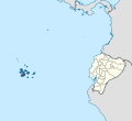
Location of the Galápagos Islands relative to continental Ecuador.
.svg)
See also
 In Spanish: Islas Galápagos para niños
