
Geography of Afghanistan facts for kids
|
||
| Continent | Asia | |
| Subregion | Central Asia | |
| Geographic coordinates | 33°00′N 65°00′E | |
| Area - Total - Water |
Ranked 41st 647,500 km² 0 km² (landlocked) |
|
| Coastline | 0 km (0 mi) | |
| Land boundaries | 5,529 km (3436 mi) | |
| Countries bordered | Pakistan 2,430 km, Tajikistan 1,206 km, Iran 936 km, Turkmenistan 744 km, Uzbekistan 137 km, China 76 km |
|
| Highest point | Nowshak, 7,486 m / 24,560 ft | |
| Lowest point | Amu Darya near Khamyab District, 258 m / 846 ft | |

Afghanistan is a country located in the middle of Asia. It is a landlocked country, meaning it has no access to the sea. Afghanistan is very mountainous, with a large part of the Hindu Kush mountains running through it. The country has four main rivers: the Amu Darya, the Hari River, the Kabul River, and the Helmand River. You can also find many smaller rivers, lakes, and streams here.
Contents
Afghanistan's Borders
Afghanistan shares 5,529 kilometers (about 3,436 miles) of borders with its neighbors. These borders are often called "porous." This means that in many places, people can cross them without much official control.
Here are the countries that border Afghanistan:
- Pakistan: The border with Pakistan is 2,430 kilometers long. It is known as the Durand Line and is located to the south and southeast of Afghanistan.
- Tajikistan: This border is 1,206 kilometers long and is to the north of Afghanistan.
- Iran: To the west of Afghanistan, the border with Iran is 936 kilometers long.
- Turkmenistan: This country shares a 744-kilometer border with Afghanistan.
- Uzbekistan: The border with Uzbekistan is 137 kilometers long.
- China: Afghanistan also has a 76-kilometer border with China. This border is in the far northeast and is a disputed area. Both Pakistan and Tajikistan also claim this region.
Land and Landscape
Afghanistan has a landscape with many rugged mountains, especially the Hindu Kush range. It also has large areas of desert.
- The lowest point in Afghanistan is the Amu Darya river, at 258 meters (846 feet) above sea level.
- The highest point is Noshaq mountain, which reaches 7,492 meters (24,580 feet) high.
Sometimes, strong earthquakes happen in the Hindu Kush mountains. In the south and southwest of the country, there can be flooding and droughts.
Natural Resources
Afghanistan is rich in many natural resources. These include:
- Natural gas
- Petroleum (oil)
- Coal
- Copper
- Uranium
- Gold
- Silver
- Chromite
- Talc
- Barites
- Sulfur
- Lead
- Zinc
- Iron ore
- Salt
- Many beautiful precious and semiprecious stones
Mountain Ranges

The Hindu Kush is a major mountain range in Afghanistan. Its highest point is Nowshak, which is 7,485 meters (24,557 feet) tall. This is also Afghanistan's highest peak.
Other mountain ranges extend southwest from the Hindu Kush. The Koh-i-Baba range reaches a great height, with its peak, Shah Fuladi, at 5,142 meters (16,870 feet).
The Safed Koh range is another important mountain system. It includes the Tora Bora area and is found near the border southeast of Kabul.
The area leading to the Khyber Pass crosses the Safed Koh mountains in eastern Afghanistan. At its highest point, the pass is 1,070 meters (3,509 feet) high at Landi Kotal. This area is very close to Pakistan, with the town of Torkham just five kilometers from the border.
Images for kids
-
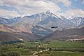
Snow-covered Koh-i-Baba mountains in Bamyan Province
-
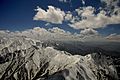
Snow-covered Hindu Kush mountains in Afghanistan
-
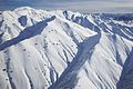
Snow-covered mountains in Paktia Province
-
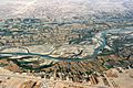
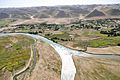
Helmand River and Boghra Canal running parallel in Helmand Province
-
Scenic view in western Afghanistan
-
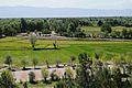
Takhar Province in northern Afghanistan
-
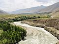
The Kokcha River in Badakhshan Province


See also
 In Spanish: Geografía de Afganistán para niños
