
Gerber Reservoir facts for kids
Quick facts for kids Gerber Reservoir |
|
|---|---|
_(klaDA0104).jpg)
Gerber Reservoir at sunset
|
|

Gerber Reservoir
Location in Oregon

Gerber Reservoir
Location in the United States
|
|
| Location | Klamath County, Oregon |
| Coordinates | 42°11′57″N 121°06′07″W / 42.1990448°N 121.1020378°W |
| Type | Reservoir |
| Primary inflows | Miller Creek and its tributaries |
| Primary outflows | Miller Creek |
| Catchment area | 234 square miles (610 km2) |
| First flooded | June 1925 |
| Max. length | 5 mi (8.0 km) |
| Max. width | 2.3 mi (3.7 km) |
| Surface area | 3,815 acres (1,544 ha) |
| Average depth | 27 ft (8.2 m) |
| Max. depth | 65 ft (20 m) |
| Shore length1 | 28.9 mi (46.5 km) |
| Surface elevation | 4,835 ft (1,474 m) |
| 1 Shore length is not a well-defined measure. | |
Gerber Reservoir is a big lake created by Gerber Dam. It's in southern Klamath County, Oregon, in the United States. This lake covers about 3,815 acres (1,544 ha). The dam and lake are named after Louis C. Gerber. He was an early settler who owned a lot of the land that became the lake.
Today, the United States Government owns the lake and the land around it. The Bureau of Reclamation and the Bureau of Land Management manage it. Gerber Reservoir is a popular spot for outdoor fun. It has two campgrounds along its west side.
Contents
History of Gerber Reservoir
Native Americans lived around what is now Gerber Reservoir for a very long time. They were here for about 6,400 years before the first European settlers arrived. Old campsites have been found in the area. Families from the Klamath and Modoc tribes used these spots. They came from early spring to fall to hunt, fish, and gather plants.
Louis C. Gerber and the Dam
Louis C. Gerber (1854–1930) and his family were among the first white settlers. In the mid-1880s, Gerber used a law called the Swamp Act. This allowed him to get 840 acres (340 ha) of land along Miller Creek. In 1895, he claimed another 168 acres (68 ha) nearby.
By 1915, Gerber had bought 20 more abandoned farms in the same area. He combined all these lands into the Gerber Ranch. In 1923, Gerber sold 1,008 acres (408 ha) to the United States Government. This land was flooded when the Bureau of Reclamation finished building the dam in June 1925. Both the dam and the lake were named in his honor.
During World War II, the island in the middle of Gerber Reservoir was used by the military. It was a bombing range. Today, ospreys and pelicans build their nests on the island.
Gerber Reservoir Watershed
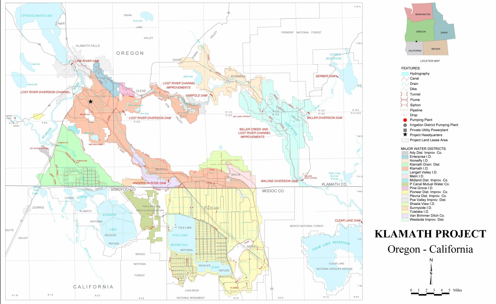
Gerber Reservoir is on the east side of the Cascade Range in southern Oregon. The lake gets its water from Miller Creek and other smaller streams. Barnes Creek, Barnes Valley Creek, and Ben Hall Creek flow into the lake all year. Some other streams dry up in the summer.
The water flows out of the lake over Gerber Dam, back into Miller Creek. From there, the water goes southwest through Miller Creek Canyon. It then reaches the Langell Valley and flows into the Lost River.
Water Sources and Land Around the Lake
The land area that drains into Gerber Reservoir covers 234 square miles (610 km2). This area has three main types of plant zones. These are coniferous forest (trees with cones), juniper woodlands, and shrub-steppe (dry lands with shrubs and grasses).
There are also some meadows within the pine forest and along streams. The areas north, south, and west of the lake are mostly pine forest. East of the lake, it's mostly juniper woodlands. The land right around the lake is shrub-steppe.
.jpg)
Plants and Trees
The coniferous forest has many ponderosa pine trees. Other trees include lodgepole pine, sugar pine, white fir, and incense cedar. Smaller plants in the forest include mountain mahogany and different types of sagebrush. You can also find rabbitbrush, bitterbrush, and manzanita.
Other common forest plants are ceanothus, huckleberry, snowberry, and blue elderberry. You might also see chokecherry, twinberry, and serviceberry. Many flowering plants grow here, like lupine, vetch, asters, and biscuitroot. Grasses like Idaho fescue are also common.
Juniper woodlands are drier areas with sandy soil. Western juniper trees are common here. The plants under the trees are similar to the pine forest. Grasses like Idaho fescue and Sandberg bluegrass grow here.
The shrub-steppe areas around Gerber Reservoir have lots of big sagebrush. Other plants include rabbitbrush, spiny hopsage, and wax currant. You can also find balsamroot, sunflowers, and different types of grass.
Environment and Climate
Gerber Reservoir is a lake made for irrigation by Gerber Dam. The lake covers about 3,815 acres (1,544 ha). It is about 5 miles (8.0 km) long and 2.3 miles (3.7 km) wide. The lake has a branching shape, with shallow parts that follow stream paths. There is one island in the middle of the lake that is always there.
The lake is about 27 feet (8.2 m) deep on average, and its deepest point is 65 feet (20 m). It is 4,835 feet (1,474 m) above sea level. Not many water plants grow in the shallow parts. However, the lake is still very productive.
| Climate data for Gerber Dam, Oregon | |||||||||||||
|---|---|---|---|---|---|---|---|---|---|---|---|---|---|
| Month | Jan | Feb | Mar | Apr | May | Jun | Jul | Aug | Sep | Oct | Nov | Dec | Year |
| Mean daily maximum °F (°C) | 42.4 (5.8) |
45.3 (7.4) |
50.6 (10.3) |
55.1 (12.8) |
65.0 (18.3) |
73.6 (23.1) |
84.9 (29.4) |
84.2 (29.0) |
76.4 (24.7) |
63.4 (17.4) |
48.1 (8.9) |
40.4 (4.7) |
60.8 (16.0) |
| Daily mean °F (°C) | 31.3 (−0.4) |
33.8 (1.0) |
38.7 (3.7) |
42.9 (6.1) |
51.1 (10.6) |
57.4 (14.1) |
66.8 (19.3) |
65.8 (18.8) |
57.3 (14.1) |
47.1 (8.4) |
36.7 (2.6) |
30.4 (−0.9) |
46.6 (8.1) |
| Mean daily minimum °F (°C) | 20.1 (−6.6) |
22.2 (−5.4) |
26.7 (−2.9) |
30.7 (−0.7) |
37.2 (2.9) |
41.1 (5.1) |
48.7 (9.3) |
47.3 (8.5) |
38.2 (3.4) |
30.8 (−0.7) |
25.3 (−3.7) |
20.3 (−6.5) |
32.4 (0.2) |
| Source: National Oceanic and Atmospheric Administration, National Climatic Data Center normals data, 1981–2010 | |||||||||||||
The lake is in the "rain shadow" of the Cascade Range. This means it gets less rain. The weather here is like other high plateaus in the northern Basin and Range Province. It has lots of sunshine, little rain, and big temperature changes. Low humidity makes water evaporate quickly. Winters are usually long, and summers are mild.
The average high temperature at Gerber Reservoir is 46.6 °F (8 °C). July is usually the warmest month, with an average high of 84.9 °F (29 °C). The average low temperature is 32.4 °F (0 °C). January is usually the coldest month, with an average low of 20.1 °F (−7 °C).
Gerber gets about 14 inches (360 mm) of rain and snow each year. Most of the precipitation comes in winter. Summers are usually dry, except for local thunderstorms. The wind usually blows from the west and south.
Wildlife at Gerber Reservoir
|
Gerber Reservoir, part of the Klamath Project.
|
The meadows near the lake have camas flowers and tufted hairgrass. Wetlands along the lake's edge have sedge, cattails, bulrushes, and willows.
Fish Species
The lake has many game fish. These include white crappie, yellow perch, bluegill, brown bullhead, largemouth bass, rainbow trout, brown trout, and brook trout. Crappie and perch are very popular with people who like to fish. Crappies over 12 inches (30 cm) long are common. The biggest crappie ever caught here was over 4 pounds (1.8 kg), which is an Oregon state record! Perch up to 14 inches (36 cm) long are also common. Other fish in the lake include tui chub and shortnose sucker.
Birds of the Area
The lake is home to many different kinds of birds. Birdwatchers can see waterfowl, songbirds, and birds of prey here. Common waterfowl include western grebe, common loon, trumpeter swan, Canada goose, and many types of ducks. Other water birds include sandhill crane, great blue heron, and American white pelican.

In the forest around the lake, you can find black-billed magpies, common ravens, and northern flickers. Several types of owls live near the lake, like the great horned owl and barn owl. Other common birds are Steller's jay, American robin, western bluebird, and western meadowlark. The lake also attracts birds of prey like prairie falcon, red-tailed hawk, osprey, golden eagle, and bald eagles.
Mammals and Other Animals
The forests and dry lands around the lake are home to many mammals. About 4,900 mule deer spend the winter in the Gerber Reservoir area. Other large mammals include pronghorn, Roosevelt elk, coyote, black bear, bobcat, and cougar.
Smaller mammals include badger, raccoon, porcupine, striped skunk, and black-tailed jackrabbit. Rodents like western gray squirrel and least chipmunk are also common. There are also five types of bats in the area.
Reptiles found here include snakes and lizards. Snake species are the common garter snake, gopher snake, and western rattlesnake. Lizards include the western fence lizard and sagebrush lizard. Four types of amphibians live in or around Gerber Reservoir: the Pacific tree frog, Oregon spotted frog, western toad, and the long-toed salamander.
Fun Things to Do
The Bureau of Land Management takes care of the area around Gerber Reservoir. Over the years, two campgrounds have been built at the lake. They have many facilities like drinking water, restrooms, campsites, picnic tables, and cooking grills. There are also boat ramps, floating docks, and fish cleaning stations. They offer garbage collection and a place for RVs to dump waste. You pay a fee to camp or use the day-use areas. There are also some simple, undeveloped campsites that are free to use.
Campgrounds and Activities
There are two campgrounds at Gerber Reservoir with 50 campsites in total. Both are on the west side of the lake. They are open all year. However, the facilities are only maintained from mid-May to mid-September. Gerber North campground has 25 campsites, and Gerber South campground also has 25.
In the summer, the lake is a popular place for fishing, boating, canoeing, and kayaking. There are also trails near the lake for hiking and mountain biking. The Gerber Watchable Wildlife Tour has nine spots to view wildlife near the lake. Gerber Reservoir is also a stop on the Klamath Basin Birding Trail.
There are some ancient sites near the lake. It is against Federal law to disturb or remove anything from these sites. If you find an ancient site, please contact the Bureau of Land Management office in Klamath Falls.
How to Get There
Gerber Reservoir is in Klamath County, Oregon. It is about 42 miles (68 km) east of Klamath Falls. It is also about 93 miles (150 km) west of Lakeview, Oregon, just off Oregon Route 140.
To get to the Gerber Reservoir campgrounds from Klamath Falls:
- Take Route 140 east to Dairy, Oregon.
- At Dairy, turn south onto Oregon Route 70 and go 5 miles (8.0 km) to Bonanza, Oregon.
- From Bonanza, continue on East Langell Valley Road for 11 miles (18 km).
- Then, turn left onto Gerber Road.
- Follow Gerber Road for 8.5 miles (13.7 km) to the Gerber recreation area.
