
Gqeberha facts for kids
Quick facts for kids
Gqeberha
|
|
|---|---|

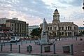
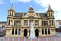
City Hall, Market Square
|
|

Gqeberha
Location in Eastern Cape

Gqeberha
Location in South Africa

Gqeberha
Location in Africa
|
|
| Country | |
| Province | |
| Municipality | Nelson Mandela Bay |
| Established | 1820 |
| Area | |
| • City | 251.03 km2 (96.92 sq mi) |
| • Metro | 1,959 km2 (756 sq mi) |
| Population
(2020)
|
|
| • City | 967,677 |
| • Rank | 54th in Africa 5th in South Africa |
| • Density | 3,854.83/km2 (9,983.95/sq mi) |
| • Metro | 1,152,915 |
| • Metro density | 588.52/km2 (1,524.3/sq mi) |
| Racial makeup (2011) | |
| • Black African | 30.6% |
| • Coloured | 27.0% |
| • Indian/Asian | 3.2% |
| • White | 37.8% |
| • Other | 1.4% |
| First languages (2011) | |
| • Afrikaans | 40.2% |
| • English | 33.2% |
| • Xhosa | 22.2% |
| • Other | 4.3% |
| Time zone | UTC+2 (SAST) |
| Postal code (street) |
6001
|
| PO box |
6000
|
| Area code | 041 |
| Zulu | iBhayi |
|---|---|
| Xhosa | iBhayi |
| Afrikaans | Port Elizabeth |
| Sesotho | Baye |
Gqeberha (pronounced "keh-BAIR-kha"), once known as Port Elizabeth and often called P.E., is a big port city in the Eastern Cape province of South Africa. It is the main city of the Nelson Mandela Bay Metropolitan Municipality, which is South Africa's second-smallest big city area by size. Gqeberha is the sixth-largest city in South Africa. It is also an important cultural, economic, and financial center for the Eastern Cape.
Port Elizabeth was started in 1820 by Sir Rufane Donkin. He was the governor of the Cape at that time. He named the city after his wife, Elizabeth, who had passed away. The Donkin Memorial in the city center reminds people of this. The government of the Cape Colony created the city when 4,000 British settlers came to Algoa Bay. This was to make the border stronger between the Cape Colony and the Xhosa people. The city is also known as "The Friendly City" or "The Windy City." In 2021, the city's name officially changed to Gqeberha. This name comes from the Xhosa and Southern Khoe name for the Baakens River that flows through the city.
Gqeberha is located on the western side of Algoa Bay on South Africa's southeastern coast. It is about 770 kilometers east of Cape Town. The city is east of the Garden Route and faces the Indian Ocean. It covers 251 square kilometers of the Nelson Mandela Bay area. The city's warm oceanic climate means it has pleasant weather all year round. Gqeberha is famous for its many blue-flag beaches along the coast. It is a popular place for holidays, both for people from South Africa and from other countries. The city also has a rich and varied cultural history. It is a starting point for adventure, outdoor activities, and big five game safaris in the Eastern Cape.
Contents
What Does the Name Gqeberha Mean?
In 1820, the growing port area of Algoa Bay was named "Port Elizabeth." This was done to remember Elizabeth Frances Markham, the wife of Sir Rufane Shaw Donkin. He was the acting Governor of the Cape Colony at the time. Settlers also simply called the place "The Bay." People who speak Xhosa call it "iBhayi" or "eBhayi." This is a Xhosa version of the Afrikaans name "die Baai," which means "the bay."
Gqeberha, the city's official name since February 23, 2021, is a Xhosa word. It is sometimes used to refer to the Baakens River that runs through the city.
A Look at Gqeberha's Past
Early Human History
People have lived in the area around Algoa Bay for a very long time. Cave sites like Howieson's Poort show evidence of early human life from about 65,000 years ago. These sites have revealed ancient tools for hunting with bows and arrows. They also show shell-bead jewelry. This suggests that modern human behavior started much earlier than we thought.
The first people to settle around Algoa Bay were hunters and gatherers, like the ancestors of the San. They arrived at least 10,000 years ago. About 2,000 years ago, farming groups, who were ancestors of the Xhosa people, slowly joined them.
British Settlers Arrive
The first Europeans to visit this area were Portuguese explorers. Bartholomeu Dias landed on St Croix Island in Algoa Bay in 1488. Vasco da Gama saw nearby Bird Island in 1497. For many centuries, maps simply called the area "a landing place with fresh water."
Later, the area became part of the Cape Colony. This region had a busy history from when the Dutch East India Company settled in 1652 until South Africa became a union in 1910.

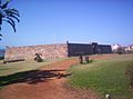
In 1799, British troops built a stone fort called Fort Frederick. They named it after the Duke of York. This fort was built to watch over the area that would become Port Elizabeth. It aimed to stop French troops from landing. Today, the fort is a preserved monument.
In 1820, about 4,000 British settlers arrived by sea. The government of the Cape Colony encouraged them to settle here. This was to make the border stronger between the Cape Colony and the Xhosa people. Sir Rufane Shaw Donkin, the acting Governor of the Cape Colony, founded the seaport town at this time.
By the early 1830s, Port Elizabeth had grown a lot. A visitor named Edmund Roberts noted that in the 1820s, the town had only four houses. By the time he visited, it had over one hundred houses and more than 1,200 people.
Port Elizabeth became its own municipality in 1861.
Growth and Railways
The Cape Government Railways were formed in 1872. When the railway to Kimberley was finished in 1873, it greatly boosted trade and population in the town. As the railway network expanded into the country, Port Elizabeth's harbor became very important. It handled imports and exports for a large part of the Cape's inland area. This fast economic growth led to Port Elizabeth being called "the Liverpool of South Africa." This was because Liverpool was a major British port. The town grew into a diverse community. It included Xhosa people, Europeans, Cape Malay people, and other immigrants.

During the Second Boer War (1899–1902), the port was a key stop for British soldiers, horses, and supplies. These were sent by train to the war front. There was no fighting in the city itself. However, many refugees, including Boer women and children, moved into the city. Some were placed in camps.
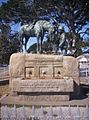
After the war, a monument was built to honor the military horses that died. This monument, called the Horse Memorial, was unveiled on February 11, 1905.
The Apartheid Era
Under apartheid, the South African government created laws to separate people by race. They also started programs to move people into different areas. From 1962, non-white people were forced to move from mixed areas. This led to the building of various townships for them. People were sometimes classified by race in unfair ways. Many citizens with mixed backgrounds were re-classified, which caused big social and political problems. Areas like South End and Fairview, which were seen as valuable land, had their non-white residents forcibly moved between 1965 and 1975.
As black South Africans worked to gain civil rights, the government became stricter. In 1977, Steve Biko, a black anti-apartheid activist, was questioned by police in Port Elizabeth before he died in Pretoria.
The Defiance Campaign of 1952
In 1952, the African National Congress (ANC) and the South African Indian Congress (SAIC) asked all South Africans to protest against unfair apartheid laws. These laws targeted black African, Indian, and coloured people. On April 6, 1952, while many white South Africans celebrated a historical event, the ANC and SAIC called for a "National Day of Pledge and Prayer." Huge meetings took place across the country. In Port Elizabeth, 20,000 people attended. Professor Z. K. Matthews and Raymond Mhlaba led the meeting.
On July 25, 1952, the day before the official start of the Defiance Campaign, 30 volunteers gathered. They prayed all night. At 5 AM on July 26, they walked to the New Brighton Railway Station. Raymond Mhlaba later remembered: "I led the very first group and we entered the 'Europeans Only' section of the New Brighton station. By half past six we were already in police vans on our way to jail. It turned out that my party (group) was the very first to defy unjust laws in the whole of South Africa. Little did we know that we were making history."
Mhlaba was the first man arrested during the campaign, and Florence Matomela was the first woman. Over 2,000 people were arrested in Port Elizabeth during the Defiance Campaign. This included important figures like Oom Gov (Govan Mbeki) and Vuyisile Mini.
Consumer Boycotts in 1985
After the United Democratic Front (UDF) was formed in 1983, people in black townships became more aware of politics. There were many protests across the country. Police presence increased in South African townships. Black South Africans demanded that public places be open to everyone. They also wanted troops removed from townships and an end to unfair treatment at work.
In May 1985, some women suggested a consumer boycott to the Port Elizabeth Black Civic Organisation (PEBCO). This was a way to hurt white-owned businesses in Port Elizabeth and challenge apartheid. The boycott began on July 15, 1985, and received huge support in townships around Port Elizabeth. By September 1985, white business owners were struggling. They asked the government to meet the demands of black South Africans. In November, the boycott was still causing great harm to white businesses. The government and PEBCO reached an agreement. It said the boycott would stop until March 1986 if business owners helped release black leaders.
In 1986, the boycotters set a deadline of March 31. They said the boycott would restart if their demands were not met. The boycott continued for nine weeks. On June 12, 1986, the government declared another state of emergency. Security forces searched townships, arresting thousands and taking documents from offices of black groups, unions, the UDF, and churches.
Modern Gqeberha
The Coega Industrial Development Zone (CIDZ) has brought a lot of new money and jobs to the Nelson Mandela Bay area. This zone has attracted over R140-billion in investments and created more than 45,000 jobs. This is very important for the Eastern Cape's economy.
In 2001, the Nelson Mandela Bay Metropolitan Municipality was created. This area includes Gqeberha, the nearby towns of Uitenhage and Despatch, and the surrounding farms. The name honors former President Nelson Mandela. In 2006, the total population of this area was about 1.3 million.
Hosting Major Sports Events
Gqeberha became a host city for the 2010 FIFA World Cup. The Nelson Mandela Bay Stadium hosted eight World Cup games. These included group stage matches, a Round of 16 game, a quarter-final, and the Third Place playoff. The World Cup took place from June 11 to July 11, 2010.
The city also hosted games for the 2013 Africa Cup of Nations. The same stadium hosted eight matches for this tournament. The Africa Cup of Nations was held from January 19 to February 10, 2013.
Gqeberha's Natural Environment
Climate and Weather
| Weather chart for Gqeberha | |||||||||||||||||||||||||||||||||||||||||||||||
|---|---|---|---|---|---|---|---|---|---|---|---|---|---|---|---|---|---|---|---|---|---|---|---|---|---|---|---|---|---|---|---|---|---|---|---|---|---|---|---|---|---|---|---|---|---|---|---|
| J | F | M | A | M | J | J | A | S | O | N | D | ||||||||||||||||||||||||||||||||||||
|
36
25
18
|
40
25
18
|
54
25
17
|
58
23
14
|
59
22
12
|
62
20
9
|
47
20
9
|
64
20
10
|
62
20
11
|
59
21
13
|
49
22
15
|
34
24
16
|
||||||||||||||||||||||||||||||||||||
| temperatures in °C precipitation totals in mm source: SAWS |
|||||||||||||||||||||||||||||||||||||||||||||||
|
Imperial conversion
|
|||||||||||||||||||||||||||||||||||||||||||||||
Gqeberha has an oceanic climate, which means it has mild temperatures all year. It is located between the winter rainfall areas of the Western Cape and the summer rainfall areas of eastern South Africa. Winters are cool but not too cold, and summers are warm but not as humid or hot as other parts of South Africa's east coast. The weather is very stable throughout the year, with extreme heat or cold being rare.
Amazing Biodiversity
The city is home to a large part of South Africa's amazing variety of life. It is where five of South Africa's seven main natural areas (biomes) meet. These are the Thicket, Grassland, Nama-Karoo, Fynbos, and Forest Biomes. You can explore these different natural areas in the city's nature reserves, which are part of the "Outward Bound Route." This route is for eco-adventures and sports, including walking and seeing wildlife.
City Design and Buildings

.jpg)
As a British colonial town, Gqeberha still has a strong British feel in its central area. The old City Hall is a national monument. The main public library is a wonderful example of Victorian Gothic architecture. There are many memorials around the city, and tours can help visitors learn about the apartheid era. The city is also known for its Art Deco style buildings, which show detailed stonework, wrought iron, and stained glass. You can also see Cape Dutch, Victorian, and Edwardian styles, which came with the 1820 British settlers.
Rivers and Beaches
The city has a long coastline, especially to the south. There are many beaches like Kings Beach, Hobie Beach, Bluewater Bay, and Sardinia Bay. Kings Beach is next to the harbor and has plenty of sand. The coastline to the northwest is rockier.
The Baakens River is the most important river in the city. It often floods when there is a lot of rain. North End Lake is the largest natural freshwater body in the city. However, it has been affected by industry, so it is not safe to drink from this lake.
The Eastern Cape has been in a serious drought since 2015. In June 2022, the Nelson Mandela Bay Municipality approved an emergency plan to get more water. This plan includes drilling more boreholes and fixing water leaks. City officials asked residents to use no more than 50 liters of water per person per day. The municipality has been working hard to fix leaks in pipes.
People of Gqeberha

- <1 /km²
- 1–3 /km²
- 3–10 /km²
- 10–30 /km²
- 30–100 /km²
- 100–300 /km²
- 300–1000 /km²
- 1000–3000 /km²
- >3000 /km²

In the 2011 census, Gqeberha was the most populated city in the Eastern Cape.
- Area: 251.03 square kilometers
- Population: 312,392 people
- Households: 99,794
| Gender | Population | % |
|---|---|---|
| Female | 162,255 | 51.94 |
| Male | 150,137 | 48.06 |
| Race | Population | % |
|---|---|---|
| White | 118,220 | 37.4 |
| Black | 95,589 | 30.60 |
| Coloured | 84,419 | 27.02 |
| Asian | 9,847 | 3.15 |
| Other | 4,317 | 1.38 |
| First language | Population | % |
|---|---|---|
| IsiZulu | 1,541 | 0.51 |
| IsiXhosa | 67,154 | 22.24 |
| Afrikaans | 121,344 | 40.19 |
| Sepedi | 472 | 0.16 |
| Setswana | 1,312 | 0.43 |
| English | 100,375 | 33.25 |
| Sesotho | 1,469 | 0.49 |
| Xitsonga | 291 | 0.10 |
| SiSwati | 171 | 0.06 |
| Tshivenda | 390 | 0.13 |
| IsiNdebele | 1,183 | 0.39 |
| Other | 10,469 | 3.35 |
| Historical population | ||
|---|---|---|
| Year | Pop. | ±% |
| 1985 | 272,844 | — |
| 1991 | 303,353 | +11.2% |
| 2001 | 237,503 | −21.7% |
| 2011 | 312,392 | +31.5% |
| 2020 | 967,767 | +209.8% |
Gqeberha's Economy
The city's economy mainly focuses on making cars, other manufacturing, and exporting goods. It is also a top place for investments in South Africa and other parts of Africa. Over the last ten years, more than $19.8 billion in foreign investments have come to the city. Many large global companies have offices or their African operations based here.
Key Industries and Trade
Historically, most trade in the region passed through Port Elizabeth. In the 1830s, many ships regularly carried goods to Europe. It became a free port in 1832, meaning goods could pass through without many taxes. The city exported items like wine, brandy, ivory, hides, wool, and ostrich feathers.
Gqeberha is a major center for South Africa's motor vehicle industry. It has many vehicle assembly plants, including General Motors, Ford, and Volkswagen. Isuzu took over GM's production plant in Struandale in 2018. Chinese company BAIC and South Africa's Industrial Development Corporation are building a large vehicle assembly plant in Coega. The FAW has also built a big plant here. Many other industries in the city make parts for cars, such as wiring harnesses, catalytic converters, and tyres.
The biggest economic sectors in Nelson Mandela Bay are manufacturing, finance, community services, and transport. These sectors create the most jobs. The city also offers many chances for tourism and fun activities because of its natural beauty, beaches, and open spaces. Nelson Mandela Bay is also a good place for making medicines, flour, meat, frozen vegetables, drinks, chocolates, cheese, yogurt, ice cream, paper, and leather products.
The city is also a major seaport. It has excellent facilities for loading cars onto ships. A new Industrial Development Zone with bigger port facilities has been built at Coega. This helps the city's industries grow and brings in new businesses.
Tourism and Fun Things to Do

Located at the end of the beautiful Garden Route along the Cape coast, Gqeberha has many beaches. Popular swimming beaches include King's Beach and Hobie Beach.
Many historic places are connected by the Donkin Heritage Trail. These include the Campanile (a bell tower) built in 1923. It remembers the arrival of the 1820 Settlers and offers a great view of the city. Other sites are the city hall (1862), the Donkin Reserve park and monument, and the old stone Fort Frederick (1799).
Route 67 is a walking trail with 67 public artworks. These artworks represent the 67 years Nelson Mandela spent working for South Africa's freedom. The art celebrates South African culture and history. It starts from the Campanile, goes up to the Vuysile Mini Market Square, and ends at the large South African flag at the Donkin Reserve. Local Eastern Cape artists created these artworks.
Other fun places to visit include the gardens at St George's Park. There is also the Nelson Mandela Metropolitan Art Museum and the museum and oceanography room at Humewood. The new Boardwalk waterfront complex is also a popular spot.
The area around Gqeberha also offers chances to see wildlife. The Addo Elephant National Park is about 72 kilometers north of the city.
It is also a great place for whale watching. You can see humpback whales from June to August and again from November to January. Southern right whales are seen from July to November, and Bryde's whales can be seen all year round.
Building and Growth

Nelson Mandela Bay has seen a lot of new building projects. These include the Baywest Mall and the Coega Development Corporation (CDC).
Baywest Mall, which opened in May 2015, is the largest shopping center in the Eastern Cape. It is on the western edge of the city and is part of Baywest City. Baywest City is a planned area with different types of buildings. It aims to become a major development hub in the city's western suburbs.
Coega, just outside the city, was an industrial development zone (IDZ). It is now a special economic zone (SEZ). It also has the second and newest port of Nelson Mandela Bay and South Africa, called Port of Ngqura. This huge project aims to attract local and foreign investments in industries that export goods. It also helps position South Africa as a key trading hub for Southern Africa.
Culture in Gqeberha
The city has one foreign cultural center, the Alliance Française of Port Elizabeth. This is a French language school and a center for French culture.
Sports and Recreation

Gqeberha is home to the St George's Park cricket ground. This is where test cricket matches are played. St George's Park is the oldest cricket ground in South Africa. It hosted the first Test match played outside of Australia or England in 1889. The Warriors, a cricket team in South Africa, are based in Gqeberha. The SA20 team Sunrisers Eastern Cape is also based here.
The Nelson Mandela Bay Stadium became the home of the South Africa Sevens rugby tournament in December 2011. This event is part of the yearly IRB Sevens World Series in rugby sevens.
The Southern Spears rugby team used to have its headquarters in Port Elizabeth. The Eastern Province Elephants rugby team is also based here. They play their home matches at Nelson Mandela Bay Stadium.
The biggest sports events in the city are the annual Ironman triathlon and the Herald Cycle tour. The Tuna classic deep-sea fishing competition brings anglers from all over the world.
The city has many facilities for cricket, rugby union, athletics, association football, and field hockey. Because it is on the coast, it is also a great place for watersports.
The city's main football club is Chippa United. They play their home games at the Nelson Mandela Bay Stadium.
The Algoa Bay Yacht Club operates out of the port.
Education in Gqeberha
Universities and Colleges
The Nelson Mandela University was created by combining three other institutions: the University of Port Elizabeth, Port Elizabeth Technikon, and the Port Elizabeth campus of Vista University. It is the largest university in the Eastern and Southern Cape. It has about 29,000 students across seven faculties and seven campuses.
High Schools
The city has many excellent government-funded and private schools. Some of these include Alexander Road High School, Collegiate Girls' High School, Grey High School, Pearson High School, Victoria Park High School, and Woodridge College.
Getting Around Gqeberha
Roads and Buses
Gqeberha is located on the N2 road. To the west, this road goes along the Garden Route to George and Cape Town. To the east, it goes through Grahamstown to East London and then to Durban. The R75 road connects the city to Despatch, Uitenhage, and the Karoo. The main roads within the city are called metropolitan or M routes.
The city's main bus station is in Market Square. The public bus service is run by the Algoa Bus Company. From 1881 to 1948, Port Elizabeth also had a tramway network.
The city has been trying to build a bus rapid transit system. This project has faced challenges, but it aims to improve public transport for residents.
Trains
Port Elizabeth railway station is part of South Africa's rail network. Local train services are run by Metrorail. The Shosholoza Meyl long-distance passenger service connects Gqeberha with Johannesburg through Bloemfontein. From Bloemfontein, you can connect to other long-distance routes.
Air Travel
Chief Dawid Stuurman International Airport (IATA code PLZ, ICAO code FAPE) serves the city. It handles both passenger and cargo flights. It is the fourth busiest airport in South Africa.
If you are visiting from another country, you currently need to fly to Johannesburg, Cape Town, or Durban first. Then, you take a domestic flight to Gqeberha. The airport's terminal building was upgraded in 2004. This created the facilities needed for international flights, but none are scheduled yet.
Sea Travel
The city has a harbor in Algoa Bay. A new international harbor has been built at Coega. This has helped the city's industries grow and brought in new businesses.
Media in Gqeberha
Radio Stations
The city has a few radio stations. These include Algoa FM, which broadcasts to the entire Eastern Cape and Garden Route, and Umhlobo Wenene FM.
Newspapers
The Herald is a daily newspaper for English readers. Die Burger serves the Afrikaans-speaking communities and has many readers.
Television
The SABC (South African Broadcasting Corporation) has a regional office in the city. Bay TV is a free-to-air station started by the Nelson Mandela Bay Municipality. It broadcasts 24 hours a day, seven days a week. The station focuses on African stories and helps local content creators. It gets money from the local government and companies.
Gqeberha's Global Connections
Sister Cities
Gqeberha has "sister city" relationships with other cities around the world. These partnerships help with cultural exchange and cooperation.
 Beira, Mozambique
 Gothenburg, Sweden
 Jacksonville, United States
 Ningbo, China
Notable People from Gqeberha
Images for kids
-
City Hall, Market Square
-
Fort Frederick
-
The Horse Memorial
-
The Donkin Reserve
-
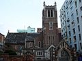
The Cathedral of St Mary the Virgin
-
The Main Library building
-
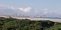
Coega Industrial Development Zone (IDZ)
-
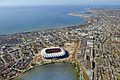
The Nelson Mandela Bay Stadium in 2009
See also
 In Spanish: Gqeberha para niños
