Greene County, Ohio facts for kids
Quick facts for kids
Greene County
|
|||
|---|---|---|---|

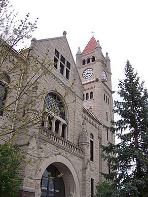
The Greene County Courthouse in Xenia
|
|||
|
|||

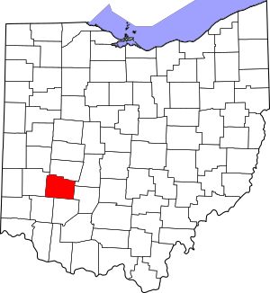
Location within the U.S. state of Ohio
|
|||
 Ohio's location within the U.S. |
|||
| Country | |||
| State | |||
| Founded | May 1, 1803 | ||
| Named for | General Nathanael Greene | ||
| Seat | Xenia | ||
| Largest city | Beavercreek | ||
| Area | |||
| • Total | 416 sq mi (1,080 km2) | ||
| • Land | 414 sq mi (1,070 km2) | ||
| • Water | 2.5 sq mi (6 km2) 0.6%% | ||
| Population
(2020)
|
|||
| • Total | 167,966 | ||
| • Estimate
(2022)
|
168,456 |
||
| • Density | 403.8/sq mi (155.89/km2) | ||
| Time zone | UTC−5 (Eastern) | ||
| • Summer (DST) | UTC−4 (EDT) | ||
| Congressional district | 10th | ||
Greene County is a cool place in the southwestern part of Ohio. In 2020, about 167,966 people lived here. The main city, called the county seat, is Xenia. The biggest city in the county is Beavercreek.
Greene County was created on March 24, 1803. It was named after General Nathanael Greene. He was an important officer during the Revolutionary War. Greene County is also part of the larger Dayton area.
Contents
Exploring Greene County's Geography
Greene County covers a total area of about 416 square miles (1,077 square kilometers). Most of this area, about 414 square miles (1,072 square kilometers), is land. Only a small part, about 2.5 square miles (6.5 square kilometers), is water.
Neighboring Counties
Greene County shares its borders with several other counties:
- Clark County (to the north)
- Madison County (to the northeast)
- Fayette County (to the east)
- Clinton County (to the south)
- Warren County (to the southwest)
- Montgomery County (to the west)
Special Protected Areas
Part of the Dayton Aviation Heritage National Historical Park is located in Greene County. This park helps protect places important to aviation history.
Main Roads and Highways
Many important roads run through Greene County, making it easy to travel around. These include:
 I-71
I-71 I-675
I-675 US 35
US 35 US 42
US 42 US 68
US 68 SR 4
SR 4 SR 72
SR 72 SR 235
 SR 343
 SR 380
 SR 444
 SR 725
 SR 844
People of Greene County
| Historical population | |||
|---|---|---|---|
| Census | Pop. | %± | |
| 1810 | 5,870 | — | |
| 1820 | 10,529 | 79.4% | |
| 1830 | 14,801 | 40.6% | |
| 1840 | 17,528 | 18.4% | |
| 1850 | 21,946 | 25.2% | |
| 1860 | 26,197 | 19.4% | |
| 1870 | 28,038 | 7.0% | |
| 1880 | 31,649 | 12.9% | |
| 1890 | 29,820 | −5.8% | |
| 1900 | 31,613 | 6.0% | |
| 1910 | 29,733 | −5.9% | |
| 1920 | 31,221 | 5.0% | |
| 1930 | 33,259 | 6.5% | |
| 1940 | 35,863 | 7.8% | |
| 1950 | 58,892 | 64.2% | |
| 1960 | 94,642 | 60.7% | |
| 1970 | 125,057 | 32.1% | |
| 1980 | 129,769 | 3.8% | |
| 1990 | 136,731 | 5.4% | |
| 2000 | 147,886 | 8.2% | |
| 2010 | 161,573 | 9.3% | |
| 2020 | 167,966 | 4.0% | |
| 2022 (est.) | 168,456 | 4.3% | |
| U.S. Decennial Census 1790-1960 1900-1990 1990-2000 2010-2020 |
|||
Greene County in 2020
In 2020, there were 167,996 people living in Greene County. There were about 65,915 households. Most people (81.5%) were White. About 6.8% were African American, and 3.3% were Asian. People of Hispanic or Latino background made up 3.1% of the population.
The average age in the county was 39 years old. About 20.5% of residents were under 18. Many adults (94%) had a high school diploma. Also, about 39.7% of adults had a college degree.
Parks and Outdoor Fun
Greene County Parks & Trails takes care of over 3,000 acres of parkland. They also manage 62 miles of paved trails for biking and walking. You can find 36 miles of river trails and 24 miles of hiking trails too. It's a great place for outdoor activities!
Learning and Education
Greene County has many schools and colleges.
Colleges and Universities
You can find several places for higher education here:
Public Colleges
- Wright State University in Fairborn
- Central State University in Wilberforce
- Clark State Community College - Greene Center in Beavercreek
Private Colleges
- Antioch College in Yellow Springs
- Antioch University Midwest in Yellow Springs
- Cedarville University in Cedarville
- Wilberforce University in Wilberforce
Public Schools
Greene County has several public school districts, each with its own high school:
- Beavercreek City School District (Beavers)
- Beavercreek High School, Beavercreek
- Bellbrook-Sugarcreek Local School District (Golden Eagles)
- Bellbrook High School, Bellbrook
- Cedar Cliff Local School District (Indians)
- Cedarville High School, Cedarville
- Fairborn City School District (Skyhawks)
- Fairborn High School, Fairborn
- Greeneview Local School District (Rams)
- Greeneview High School, Jamestown
- Xenia Community City School District (Buccaneers)
- Xenia High School, Xenia
- Yellow Springs Exempted Village School District (Bulldogs)
- Yellow Springs High School, Yellow Springs
- Greene County Career Center, Xenia (a vocational school for job training)
Private Schools
- Legacy Christian Academy (Knights)
- St. Brigid School (Irish)
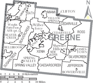
Communities in Greene County
Cities
- Beavercreek
- Bellbrook
- Fairborn
- Kettering (mostly in Montgomery County)
- Xenia (the county seat)
Villages
- Bowersville
- Cedarville
- Clifton (part of it)
- Jamestown
- Spring Valley
- Yellow Springs
Townships
- Bath
- Beavercreek
- Caesarscreek
- Cedarville
- Jefferson
- Miami
- New Jasper
- Ross
- Silvercreek
- Spring Valley
- Sugarcreek
- Xenia
Other Places to Know
- Shawnee Hills (a census-designated place)
- Wilberforce (a census-designated place)
- Wright-Patterson Air Force Base (a military base)
Small Unincorporated Communities
See also
 In Spanish: Condado de Greene (Ohio) para niños
 | Selma Burke |
 | Pauline Powell Burns |
 | Frederick J. Brown |
 | Robert Blackburn |


