History of Winnipeg facts for kids
The history of Winnipeg tells the story of this important Canadian city. It starts with the Indigenous peoples who lived here for thousands of years. Later, Europeans settled the area. The first forts were built in the 1700s. The Selkirk Settlement began in 1812. Winnipeg officially became a city in 1873. It grew very fast in the late 1800s and early 1900s. After World War I, its role as a major business hub in Western Canada changed. Winnipeg and its nearby areas grew a lot after 1945. The current City of Winnipeg was formed in 1972 when many smaller towns joined together.
Contents
Ancient History of Winnipeg
Winnipeg is located where the Assiniboine River and the Red River meet. This spot is called The Forks. It has been a key meeting place for thousands of years. Indigenous peoples used these rivers as travel routes for their canoes. Many First Nations lived in this area.
In ancient times, people used the area for camps, hunting, fishing, and trading. They also farmed further north. Rivers helped people like the Assiniboine, Ojibway, Anishinaabe, Mandan, Sioux, Cree, and Lakota travel and share knowledge. They traded goods and ideas.
The name Winnipeg comes from Lake Winnipeg to the north. It means "cloudy water" in a native language. This refers to the silt-filled water from the prairies. The first farming in Manitoba happened along the Red River. People grew corn and other crops there before Europeans arrived.
European Arrival (1700–1869)
Early Fur Trade
The first Indigenous fur traders in the area traded with the Hudson's Bay Company and the North West Company. The Hudson's Bay Company claimed a huge area called Rupert's Land in the late 1600s. This included the land where Winnipeg is now. Fur traders working with the Hudson's Bay Company traveled along the Red River.
In 1738, Sieur de La Vérendrye built Fort Rouge on the Assiniboine River. This was an early trading post. It was later abandoned. French traders were in the area for decades before British traders arrived around 1767. Fort Gibraltar was built at The Forks by the North West Company in 1809.
First European Settlements
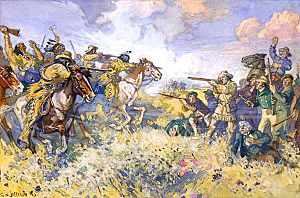
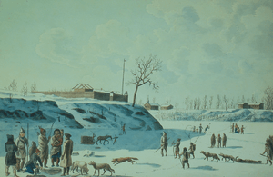
In 1811, a Scottish nobleman named Lord Selkirk received a large piece of land from the Hudson's Bay Company. He called it Assiniboia. His goal was to create the first lasting farm settlement along the Red River. This settlement, called the Red River Settlement, started in 1812. Fort Douglas was built in 1813–14. This was the first European farming colony on the northern plains.
The new settlement caused more tension between the Hudson's Bay Company and the North West Company. In the 1810s, these two companies fought for control of the fur trade. They destroyed each other's forts in battles, like the Battle of Seven Oaks. In 1821, the two companies were forced to merge under the Hudson's Bay name.
With control over the fur trade, the Hudson's Bay Company moved its operations to Fort Gibraltar in 1822. They renamed it Fort Garry. This fort was later torn down. In 1835, a new, stronger Fort Garry was built nearby. This stone fort became the company's main post until the fur trade declined in the 1870s.
Starting in the early to mid-1800s, the Métis began settling in the Red River Valley. The Métis are an ethnic group with both Indigenous and European heritage. They were very involved in the fur trade as hunters and traders. Important trading posts included Fort Alexander and Fort Bas-de-la-Rivière. Also, illegal trade routes, called the Red River Trails, grew between the Red River Colony and Saint Paul in the United States.

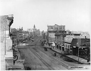
By 1862, a small village began to form north of Fort Garry. This was near where Portage Avenue and Main Street are today. This village became a center for businesses. It was the start of a new city. This area remained the main business heart of Winnipeg for a long time.
Winnipeg Becomes a City (1870–1913)
In 1869, the Hudson's Bay Company gave its land rights over Rupert's Land back to the British Crown. In 1870, the British gave this land to the Canadian government. However, the people of Red River formed their own government and took control of Fort Garry. They wanted to negotiate with Canada.
This led to the Red River Rebellion, a conflict between the local government, led by Louis Riel, and the Canadian government. The Métis and the government eventually reached an agreement. This led to the Manitoba Act. Manitoba became a province of Canada on July 15, 1870. The Wolseley expedition was sent to Fort Garry to end the rebellion. They arrived on August 24, 1870, and captured the fort. Riel and his supporters had already left.
Growing and Becoming Official
The small group of houses and businesses near Portage and Main became known as "Winnipeg." This helped people tell it apart from the Hudson's Bay Company's Fort Garry. By early 1873, this settlement was the main population and business center in the Red River area. On November 8, 1873, Winnipeg officially became a city. It elected its first mayor, Francis Evans Cornish, two months later. In 1876, the post office officially used the name "Winnipeg."
The Hudson's Bay Company owned a large piece of land near Fort Garry. As the city grew, the company divided this land into blocks to sell. This helped the city expand.
Railways and Economic Boom
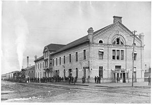
The first train arrived in Winnipeg in 1877. A railway connection to St. Paul began in 1878. The Canadian Pacific Railway completed the first direct rail link from eastern Canada in 1881. This railway crossed the Red River at Point Douglas. The arrival of the railway brought many new people to Winnipeg and the Canadian Prairies. You can learn about Winnipeg's rail history at the Winnipeg Railway Museum.
With the railways, Winnipeg's population grew very fast. It went from 7,900 people in 1881 to over 179,000 in 1921. Winnipeg was the only large city on the Canadian prairies in 1891. It became the main business center for the prairie provinces. Later, other cities like Calgary and Edmonton grew. Winnipeg's importance as the top economic center in Western Canada lessened, but it remained a strong center for finance and the grain trade.
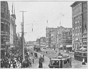
Winnipeg became a major wholesaling center in the late 1800s. Many large warehouses and factories were built in the northern part of the downtown area. Today, this warehouse area is known as the Exchange District.
The Manitoba Legislative Building shows the hopeful spirit of these boom years. It was built mostly of Tyndall Stone and opened in 1920. Its dome has a bronze statue covered in gold leaf, known as the "Golden Boy." The building was designed to hold representatives for three million people, which was the expected population of Manitoba at the time.
City's Layout
As Winnipeg grew quickly, different neighborhoods formed based on class and background. The North End became home to many working-class people and new immigrants. Wealthy citizens, often Canadian-born or British-born, settled in the south end of the city. This north-south divide continued for much of the 1900s.
Winnipeg became known for its multicultural character during this time. Many new Canadians from Eastern Europe settled in the city's North End. In the early 1900s, the neighborhood of Crescentwood became home to many of Winnipeg's rich citizens.
In 1904, the T. Eaton Company opened a new department store on Portage Avenue. This caused other shops and entertainment places to move from Main Street to Portage Avenue. Main Street, however, remained important as the city's "Bankers’ Row."
World Wars and Tough Times (1914–1945)
World War I's Impact
When the Panama Canal opened in 1914, Winnipeg's central location for Canada's east-west rail system became less important for international trade. This helped Vancouver grow and eventually become Canada's third-largest city. Winnipeg's fast economic growth was stopped by World War I in 1914. The war greatly reduced British money investments and European immigration.
Between the Wars
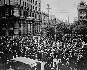
After World War I, there was a recession. Working conditions were bad, and many soldiers returned home. In May 1919, 35,000 Winnipeggers went on strike. This was called the Winnipeg General Strike of 1919. After many arrests and some violence, the strike ended on June 21, 1919. Police charged a group of strikers. Two strikers were killed, and many were injured. This day became known as Bloody Saturday. The strike made the population very divided. One of the strike leaders, J. S. Woodsworth, later helped start Canada's first major socialist party.
Canada's economy got better in the early 1920s. Winnipeg started to grow again as a center for grain trade, manufacturing, and wholesaling. However, Winnipeg did not grow as fast as it did before 1914. Its economic importance compared to other Western Canadian cities also declined.
Winnipeg's population continued to grow in the 1920s, but more slowly. Most of this growth was in Winnipeg's suburban areas. This was because of streetcar service and more people owning cars. The downtown area remained the main center for trade, shopping, and entertainment.
In the downtown area, Portage Avenue became the main shopping street in the 1920s. This was especially true after the huge Hudson's Bay Company department store opened there in 1926.
The stock market crash of 1929 made things worse for Winnipeg. The Great Depression caused huge unemployment. This was made worse by drought and low farm prices.
World War II's Role

The Depression ended when World War II started in 1939. Winnipeg played a big part in the war effort. The Winnipeg Grenadiers were among the first Canadians to fight against Japan in the Battle of Hong Kong. Many died or were captured and treated badly in prisoner-of-war camps.
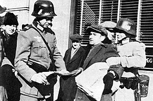
In 1942, the Canadian government staged a fake Nazi invasion of Winnipeg. This was to make people more aware of the war in Europe. The fake invasion looked very real. It included Nazi planes and troops. Air raid sirens sounded, and the city went dark. This event was covered by media across North America and shown in the film "If Day".
Winnipeg was also a major center for the British Commonwealth Air Training Plan (BCATP). This plan trained flight crews away from the war zones in Europe. Pilots, navigators, and other air crew members passed through Winnipeg. Winnipeg was a headquarters for this training.
Modern Winnipeg (1946 to Today)
After the War (1946–1971)
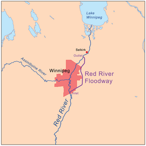
After World War II, Winnipeg felt a new sense of hope. There was a boom in housing construction. But building stopped because of the 1950 Red River flood. This was the biggest flood to hit Winnipeg since 1861. Water stayed high for 51 days. Many dikes broke, and bridges were destroyed. Nearly 100,000 people had to leave their homes. This was Canada's largest evacuation ever. Soldiers helped with the relief efforts.
To protect the city from future floods, the Red River Floodway was built. This floodway diverts flood water around Winnipeg. Construction started in 1962 and finished in 1968.
In the 1960s, Winnipeg had a lively rock n' roll music scene. Famous bands like The Guess Who and musician Neil Young started their careers here.
One Big City
Joining Together
After 1945, the areas around Winnipeg grew a lot. The City of Winnipeg was the largest of thirteen cities and towns in the area. These towns joined together to form "Unicity" on July 27, 1971. This became official on January 1, 1972. Unicity combined the 13 local governments into one City of Winnipeg. The goal was to make city planning and services better. It also aimed to make property taxes fairer across the different areas. To make sure local interests were heard, Unicity created 13 advisory groups.
The City of Winnipeg Act created the current city. Many municipalities like Transcona, St. Boniface, St. Vital, and others joined with the old City of Winnipeg.
Making Downtown Better
In 1979, the old Eaton's catalogue building became the city's first downtown mall. It was called Eaton Place. It later changed its name to Cityplace. This happened after the old Eaton's store was torn down in 2002.
After the 1979 energy crisis, Winnipeg faced an economic slowdown. Businesses like the Winnipeg Tribune newspaper and meat packing plants closed. In 1981, Winnipeg was one of the first Canadian cities to sign an agreement to improve its downtown. The federal, provincial, and city governments put over $271 million into downtown Winnipeg over 20 years. This money helped build the Portage Place mall and other buildings.
In 1989, old railway yards at The Forks were turned into a new area. The Forks became Winnipeg's most popular tourist spot.
In 1993, the residents of Headingley left Winnipeg. They felt their community's needs were not being met. They officially became their own municipality.
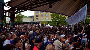
In 1996, Winnipeg's National Hockey League team, the Winnipeg Jets, moved to Phoenix, Arizona. Fifteen years later, the Atlanta Thrashers team moved to Winnipeg for the 2011–12 season.
During the 1997 Red River flood, the floodway was used to its maximum. The Red River Floodway Expansion was completed in 2010. It cost over $665 million CAD.
City Government History
The first elections for Winnipeg's city government happened shortly after it became a city in 1873. On January 5, 1874, Francis Evans Cornish became the first mayor. Until 1955, mayors could only serve one term. The city government had 13 aldermen and one mayor. This number stayed the same until 1920.
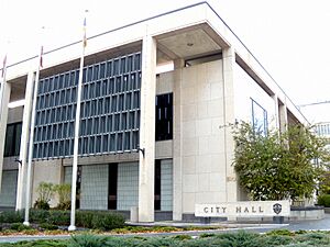
A new City Hall was started in 1875. This building had many problems and had to be held up by supports. It was later torn down. A new City Hall was built in 1883, and another in 1886. The 1886 building was very fancy. It showed Winnipeg's growth in the late 1800s. This building stood for nearly 80 years. It was torn down in 1962.
The Winnipeg City Council decided to build a "Civic Centre." This plan included an administrative building and a council building. A police headquarters and a parking garage were added later. These four buildings were finished in 1964. They cost $8.2 million. The Civic Centre and the Manitoba Centennial Centre were connected by tunnels in 1967. The Public Safety Building and parking garage were torn down in 2019-2020 for a new development.
See also
- History of Manitoba
- Timeline of Winnipeg history
 | Selma Burke |
 | Pauline Powell Burns |
 | Frederick J. Brown |
 | Robert Blackburn |


