Iron County, Utah facts for kids
Quick facts for kids
Iron County
|
|
|---|---|

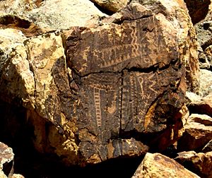
The Parowan Gap petroglyphs, a well-known landmark in Iron County, July 2007
|
|

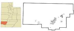
Location within the U.S. state of Utah
|
|
 Utah's location within the U.S. |
|
| Country | |
| State | |
| Founded | January 31, 1850 (created) January 17, 1851 (organized) |
| Named for | Iron mines |
| Seat | Parowan |
| Largest city | Cedar City |
| Area | |
| • Total | 3,301 sq mi (8,550 km2) |
| • Land | 3,297 sq mi (8,540 km2) |
| • Water | 4.4 sq mi (11 km2) 0.1% |
| Population
(2020)
|
|
| • Total | 57,289 |
| • Estimate
(2023)
|
64,211 |
| • Density | 17.3550/sq mi (6.7008/km2) |
| Time zone | UTC−7 (Mountain) |
| • Summer (DST) | UTC−6 (MDT) |
| Congressional district | 2nd |
Iron County is a county located in the southwestern part of Utah, United States. In 2020, about 57,289 people lived here. The main town where the county government is located is Parowan. However, the biggest city in Iron County is Cedar City.
Iron County is also part of the Cedar City, UT Micropolitan Statistical Area. This means it's an important area for jobs and businesses, even though it's not a huge city.
Contents
Exploring Iron County's Past
Evidence shows that people from the Fremont culture lived in what is now Iron County between 750 and 1250 AD. You can still see ancient rock carvings, called petroglyphs, at a famous spot called Parowan Gap. These carvings were made by different groups of people over many years.
Before Europeans arrived, the Paiute people lived in the Parowan Valley. Their descendants now live on the Southern Paiute Indian Reservation, which has its main office in Cedar City.
First Explorers and Settlers
The first European explorers to travel through the Iron County area were part of the Domínguez–Escalante expedition in 1776. Later, in 1826, a fur trapper named Jedediah Smith was the first Anglo-American to pass through the area.
Settlement by European-Americans began in 1851. Brigham Young, who was the leader of LDS Church, asked members to move to this area from northern colonies. A settlement called Coal Creek started in 1851, which later grew into Cedar City.
How Iron County Was Formed
To create a local government, the State of Deseret legislature officially created Iron County on January 31, 1850. It was first called "Little Salt Lake County." But on December 3, 1850, its name was changed to Iron County. This name came from the Iron mines found in the area.
The county's borders were very large at first, stretching across Utah into what would become Colorado and Nevada. Over the years, the borders were changed many times. The final changes were made in 1892, and the county's shape has been the same ever since.
Discovering Iron County's Geography
Iron County is located on the western edge of Utah. Its western border touches the state of Nevada. The land in Iron County is very diverse. In the west, you'll find dry areas like the Escalante Desert and parts of the Great Basin. As you move east, you'll see green meadows and forests on the High Plateau.
A famous natural wonder here is Cedar Breaks National Monument, which has colorful rock formations. The highest point in the county is Brian Head, which stands at 11,307 feet (3,446 meters) above sea level. The county covers a total area of about 3,301 square miles (8,550 km²). Most of this is land, with only a small amount of water.
Main Roads for Travel
- Interstate 15
- Utah State Route 14
- Utah State Route 56
- Utah State Route 130
- Utah State Route 143
- Utah State Route 148
Neighboring Counties
- Beaver County - north
- Garfield County - east
- Kane County - southeast
- Washington County - south
- Lincoln County, Nevada - west
Protected Natural Areas
- Cedar Breaks National Monument
- Dixie National Forest (part)
- Fishlake National Forest (part)
- Red Cliffs National Conservation Area (part)
- Zion National Park (part)
Lakes and Valleys
- Little Salt Lake
- Newcastle Reservoir
- Quichapa Lake
- Dan Leigh Hollow (a valley)
Iron County's Population
| Historical population | |||
|---|---|---|---|
| Census | Pop. | %± | |
| 1850 | 360 | — | |
| 1860 | 1,010 | 180.6% | |
| 1870 | 2,277 | 125.4% | |
| 1880 | 4,013 | 76.2% | |
| 1890 | 2,683 | −33.1% | |
| 1900 | 3,546 | 32.2% | |
| 1910 | 3,933 | 10.9% | |
| 1920 | 5,787 | 47.1% | |
| 1930 | 7,227 | 24.9% | |
| 1940 | 8,331 | 15.3% | |
| 1950 | 9,642 | 15.7% | |
| 1960 | 10,795 | 12.0% | |
| 1970 | 12,177 | 12.8% | |
| 1980 | 17,349 | 42.5% | |
| 1990 | 20,789 | 19.8% | |
| 2000 | 33,779 | 62.5% | |
| 2010 | 46,163 | 36.7% | |
| 2020 | 57,289 | 24.1% | |
| 2023 (est.) | 64,211 | 39.1% | |
| US Decennial Census 1790–1960 1900–1990 1990–2000 2010 2020 |
|||
Population Facts (2020)
In 2020, the population of Iron County was 57,289 people. This means there were about 17.4 people living in each square mile.
Most people in Iron County identify as White (about 83%). Other groups include Native American, Asian, and African American. About 9.6% of the population is Hispanic or Latino.
The population is almost evenly split between males and females. The median age in Iron County is 28.9 years old. This means half the people are younger than 28.9, and half are older. About 28.4% of the population is under 18 years old.
Ancestry of Residents
Many people in Iron County have ancestors from different parts of the world. The top 5 ethnic groups are:
Fun Things to Do in Iron County
Iron County offers many outdoor activities and places to explore.
- Woods Ranch Recreation Area: This spot is in a pine and aspen forest. You can go hiking, fishing, and have picnics here. There are also volleyball courts and restrooms.
- Three Peaks Recreation Area: This area is known for its volcanic rocks and hills. It's a great place for rock climbing, picnics, fishing, off-road vehicle use, and bike riding.
- Shooting Range: A place for target practice.
- Brian Head Ski Resort: A popular place for skiing and snowboarding in the winter.
Communities in Iron County
Cities
- Cedar City
- Enoch
- Parowan (This is the county seat, where the main government offices are.)
Towns
Census-Designated Places (CDPs)
These are areas identified by the census for statistical purposes, but they are not officially incorporated cities or towns.
- Beryl Junction
- Cedar Highlands
- Modena
- Newcastle
- Summit
Unincorporated Communities
These are small communities that are not part of any city or town.
- Beryl
- Buckhorn Springs
- Hamiltons Fort
- Hamlin Valley
- Lund
- Old Irontown
- State Line
- Zane
Former Communities
These are places that used to be communities but are no longer active or recognized as such.
- Gold Springs
- Iron Springs
- Uvada
Education in Iron County
There is one main school district that serves Iron County: the Iron School District.
See also
 In Spanish: Condado de Iron (Utah) para niños


