Jefferson County, Arkansas facts for kids
Quick facts for kids
Jefferson County
|
|
|---|---|
| County of Jefferson | |

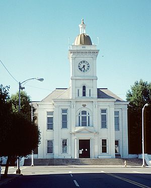
The south façade of the Jefferson County Courthouse
|
|

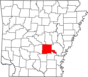
Location within the U.S. state of Arkansas
|
|
 Arkansas's location within the U.S. |
|
| Country | |
| State | |
| Established | November 2, 1829 |
| Named for | Thomas Jefferson |
| Seat | Pine Bluff |
| Largest city | Pine Bluff |
| Other cities | Altheimer, Humphrey, Redfield, White Hall |
| Area | |
| • Total | 914 sq mi (2,370 km2) |
| • Land | 871 sq mi (2,260 km2) |
| • Water | 43 sq mi (110 km2) 4.7%% |
| Population
(2020)
|
|
| • Total | 67,260 |
| • Estimate
(2023)
|
63,661 |
| • Density | 73.59/sq mi (28.413/km2) |
| Time zone | UTC−6 (Central) |
| • Summer (DST) | UTC−5 (CDT) |
| ZIP Codes |
71601–71603, 71644, 71659, 72004, 72046, 72073, 72079, 72132, 72150, 72152, 72160, 72168, 72175
|
| Area code | 501, 870 |
| Congressional district | 4th |
Jefferson County, Arkansas is a county in the U.S. state of Arkansas. It is located in a part of Arkansas called the Arkansas Delta, which is west of the Mississippi River. Jefferson County has five cities, two towns, and 20 townships. The Arkansas River flows through the middle of the county. This river was very important for its growth and was once the main way to travel and transport goods.
In 2020, about 67,260 people lived in Jefferson County. The main city and the place where the county government is located is Pine Bluff. Jefferson County is part of the larger Pine Bluff metropolitan area.
Jefferson County was created on November 2, 1829. It was formed from parts of Pulaski County and Arkansas County in what was then the Arkansas Territory. The county is named after Thomas Jefferson, who was the third U.S. president. A famous event, the Battle of Pine Bluff, happened here on October 25, 1863, during the American Civil War.
Contents
History of Jefferson County
Early Days and Founding
Long ago, the Quapaw people lived in the area that is now Jefferson County. In 1686, a French explorer named Henri de Tonti set up a trading post called Arkansas Post. He claimed this land for the King of France.
In March 1819, Robert Crittenden became the secretary of the Arkansas Territory. That same year, a man named Joseph Bonne built a cabin on a "high bluff covered with pine trees" by the Arkansas River. This spot later became the city of Pine Bluff. A few years later, James Scull opened an inn across the river.
In 1824, the Quapaw people signed a treaty with the U.S. government. They gave up their tribal lands in the area.
Growth and Development
As steamboat travel became popular, more people moved to the area. Important people like Antoine Barraque, a French trader, and brothers James T. and John Pullen came to live here. Streets and townships are named after them today.
On November 2, 1829, the governor approved the creation of Jefferson County. At first, Bonne's cabin was used for county business. But by August 1832, "Pine Bluff Town" became the official county seat.
Large cotton farms grew in the county, especially along the river. These farms relied on the hard work of enslaved African Americans. They made up most of the population before the American Civil War. After the war, cotton farming continued to be very important to the county's economy.
Political Changes After the Civil War
Because many African Americans lived in Jefferson County, it became a center for Black political power after the Civil War. Between 1871 and 1893, twenty-two different African Americans from Jefferson County were elected to the Arkansas state legislature. This was more than from any other county. However, later laws known as Jim Crow laws made it very hard for Black people to take part in politics.
In 1886, Jefferson County produced more cotton than any other county in Arkansas. It was the second-highest producer in the entire Southern United States. Many transportation companies, like the Cotton Belt Route and Missouri Pacific Railroad, served the county at that time.
Geography of Jefferson County
Jefferson County covers about 914 square miles (2,367 square kilometers). Most of this area, about 871 square miles (2,256 square kilometers), is land. The remaining 43 square miles (111 square kilometers) is water, which is about 4.7% of the total area.
The county is located about 43 miles (69 kilometers) southeast of Little Rock. It is also about 144 miles (232 kilometers) southwest of Memphis, Tennessee.
How People Travel (Transit)
- Pine Bluff Transit helps people get around Pine Bluff.
Main Roads (Major Highways)
 Interstate 530
 U.S. Highway 65
 U.S. Highway 79
 U.S. Highway 270
 U.S. Highway 425
 Highway 15
 Highway 31
 Highway 46
 Highway 54
 Highway 81
 Highway 88
Neighboring Counties (Adjacent Counties)
Jefferson County shares borders with these counties:
- Lonoke County (to the northeast)
- Arkansas County (to the east)
- Lincoln County (to the southeast)
- Cleveland County (to the southwest)
- Grant County (to the west)
- Pulaski County (to the northwest)
People of Jefferson County (Demographics)
| Historical population | |||
|---|---|---|---|
| Census | Pop. | %± | |
| 1830 | 772 | — | |
| 1840 | 2,566 | 232.4% | |
| 1850 | 5,834 | 127.4% | |
| 1860 | 14,971 | 156.6% | |
| 1870 | 15,733 | 5.1% | |
| 1880 | 22,386 | 42.3% | |
| 1890 | 40,881 | 82.6% | |
| 1900 | 40,972 | 0.2% | |
| 1910 | 52,734 | 28.7% | |
| 1920 | 60,330 | 14.4% | |
| 1930 | 64,154 | 6.3% | |
| 1940 | 65,101 | 1.5% | |
| 1950 | 76,075 | 16.9% | |
| 1960 | 81,373 | 7.0% | |
| 1970 | 85,329 | 4.9% | |
| 1980 | 90,718 | 6.3% | |
| 1990 | 85,487 | −5.8% | |
| 2000 | 84,278 | −1.4% | |
| 2010 | 77,435 | −8.1% | |
| 2020 | 67,260 | −13.1% | |
| 2023 (est.) | 63,661 | −17.8% | |
| U.S. Decennial Census 1790–1960 1900–1990 1990–2000 2010–2016 |
|||
A census is an official count of a population. It helps us understand how many people live in an area and what groups they belong to.
2020 Census Information
| Race | Number | Percentage |
|---|---|---|
| White (not Hispanic) | 25,230 | 37.51% |
| Black or African American (not Hispanic) | 37,712 | 56.07% |
| Native American | 212 | 0.32% |
| Asian | 664 | 0.99% |
| Pacific Islander | 93 | 0.14% |
| Other/Mixed | 1,861 | 2.77% |
| Hispanic or Latino | 1,488 | 2.21% |
In 2020, the census showed that 67,260 people lived in Jefferson County. There were 27,593 households (groups of people living together) and 16,356 families.
2010 Census Information
According to the 2010 census, there were 77,435 people living in the county.
- 55.1% were Black or African American.
- 42.0% were White.
- 0.8% were Asian.
- 0.3% were Native American.
- 0.7% were of some other race.
- 1.2% were of two or more races.
- 1.6% of the people were Hispanic or Latino (this group can be of any race).
Education in Jefferson County
Several school districts serve the different parts of Jefferson County:
- Pine Bluff School District
- Watson Chapel School District
- White Hall School District
- DeWitt School District (its main office is in another county)
Over the years, some smaller school districts in the county have joined together to form larger ones. For example, the Dollarway School District joined the Pine Bluff district in 2021.
Places in Jefferson County
Cities
- Altheimer
- Humphrey (most of it is in Arkansas County)
- Pine Bluff (this is the county seat)
- Redfield
- White Hall
Towns
Census-Designated Places (CDPs)
These are areas that are like towns but are not officially incorporated as cities or towns.
Other Communities
Townships
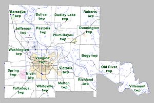
A township is a small area within a county, often used for local government or land division. Townships in Arkansas are the divisions of a county. Each township includes unincorporated areas; some may have incorporated cities or towns within part of their boundaries. Arkansas townships have limited purposes in modern times. However, the United States Census does list Arkansas population based on townships (sometimes referred to as "county subdivisions" or "minor civil divisions"). Townships are also of value for historical purposes in terms of genealogical research. Each town or city is within one or more townships in an Arkansas county based on census maps and publications. The townships of Jefferson County are listed below; listed in parentheses are the cities, towns, and/or census-designated places that are fully or partially inside the township.
- Barraque (includes Redfield)
- Bogy
- Bolivar
- Dudley Lake
- Dunnington (includes Wabbaseka)
- Jefferson
- Melton
- Niven
- Old River
- Pastoria
- Plum Bayou (includes Altheimer, Sherrill)
- Richland
- Roberts (includes Humphrey)
- Spring
- Talladega
- Vaugine (includes Pine Bluff)
- Victoria
- Villemont
- Washington (includes White Hall)
- Whiteville
Former Populated Places
These are places that used to have people living in them but are no longer considered populated communities.
- Anrep
- Bruce
- Byrd's Spring
- Clements
- College Park
- Diantha
- Dolton
- Doylestown
- Fairfield
- Faith
- Kratnek
- Lamb
- Lamberts
- Linn
- Noble's Lake
- Plum Bayou
- Ray Station
- Red Bluff
- Samples
- Secrest
- Sleeth
- Walden
- Waldstein
Notable People from Jefferson County
- Bobby Hutton (1950-1968), who was the Treasurer of the Black Panther Party.
- Bobby King (1941–1983), a Chicago blues guitarist, singer, and songwriter.
- Kemp Toney (1876-1955), a politician who represented Jefferson County in the Arkansas House of Representatives from 1931 to 1948.
- Elizabeth Rice, an American actress.
See also
 In Spanish: Condado de Jefferson (Arkansas) para niños


