List of Arizona hurricanes facts for kids
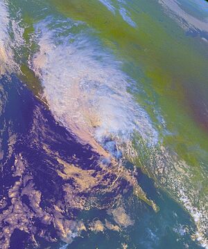
Arizona sometimes gets hit by powerful storms called hurricanes. Most of these storms start in the eastern Pacific Ocean. They usually hit land in Mexico and then weaken before reaching the United States.
This means Arizona often gets only the leftover moisture from these storms. This moisture can cause heavy rain and sometimes flash floods. About every five years, a tropical storm or a weaker tropical depression is strong enough to actually enter Arizona. Flash floods from these storm leftovers happen more often, about every two years.
Tropical storms are not super common in Arizona. This is because the main wind patterns usually push storms forming in the Eastern Pacific Ocean away from the U.S. coast. Only about 6% of all Pacific hurricanes ever reach U.S. territory.
However, not all storms affecting Arizona come from the Pacific. For example, in 2008, an Atlantic hurricane named Hurricane Dolly brought rain to eastern Arizona. Another Atlantic storm also reached Arizona as a tropical depression. Many of these storms also affected California.
Even though they are rare, hurricanes are a big deal for Arizona's weather. In years when a tropical cyclone affects Arizona, it can bring up to a quarter of the total rainfall to areas near the Colorado River. These storms can also cause huge downpours in specific spots. For example, the state's record for the most rain in 24 hours (about 12 inches or 304 mm) happened during Hurricane Nora in 1997. This heavy rain can lead to major flash floods, like those from Tropical Storm Octave in 1983 or Tropical Storm Emilia in 2006.
Contents
When Do Storms Hit Arizona?
| Month | Number of storms |
|---|---|
| June |
2
|
| July |
2
|
| August |
12
|
| September |
21
|
| October |
10
|
Tropical cyclones don't hit Arizona very often. On average, a tropical storm or tropical depression enters the state about once every five years. But, indirect flash floods from the leftover moisture of these storms are more common. They happen about every two years.
Storms that reach the southwestern United States, including Arizona, usually form closer to the Mexican coast. This makes it more likely for them to turn north. This often happens later in the Pacific hurricane season, from late August to early October. During this time, weather patterns can guide hurricanes towards Arizona.
The moisture from these Arizona-bound storms can bring a lot of rain to the region. In years when hurricanes approach Arizona, the eastern and northern parts of the state get about 6–8% of their monsoon-season rain from these tropical systems. In the southwestern part of the state, this can be as much as 25% of their monsoon-season rainfall.
Notable Storms in Arizona's History
| Category | m/s | knots | mph | km/h |
|---|---|---|---|---|
| 5 | ≥ 70 | ≥ 137 | ≥ 157 | ≥ 252 |
| 4 | 58–70 | 113–136 | 130–156 | 209–251 |
| 3 | 50–58 | 96–112 | 111–129 | 178–208 |
| 2 | 43–49 | 83–95 | 96–110 | 154–177 |
| 1 | 33–42 | 64–82 | 74–95 | 119–153 |
| TS | 18–32 | 34–63 | 39–73 | 63–118 |
| TD | ≤ 17 | ≤ 33 | ≤ 38 | ≤ 62 |
Tropical storms are a key source of rain for Arizona. They bring moisture to the monsoon season, sometimes causing large floods. Most storms that have affected Arizona happened later in the Pacific hurricane season. Only the leftovers of storms have reached the state before August.
| Storm | Peak intensity | Season | Intensity | Date |
|---|---|---|---|---|
| Unnamed | Unknown | 1921 | Remnant low | August 20, 1921 |
| Unnamed | Unknown | 1921 | Tropical depression | September 30, 1921 |
| Unnamed | Unknown | 1926 | Remnant low | September 20, 1926 |
| Unnamed | Unknown | 1927 | Remnant low | September 7, 1927 |
| One | Category 1 | 1929 | Tropical depression | June 30, 1929 |
| Unnamed | Unknown | 1935 | Tropical storm | August 22, 1935 |
| Unnamed | Tropical storm | 1951 | Tropical storm | August 3, 1951 |
| Unnamed | Category 1 | 1958 | Tropical storm | October 6, 1958 |
| Claudia | Tropical storm | 1962 | Tropical storm | September 25, 1962 |
| Tillie | Tropical storm | 1964 | Remnant low | September 9, 1964 |
| Emily | Category 1 | 1965 | Remnant low | September 6, 1965 |
| Kirsten | Tropical storm | 1966 | Remnant low | September 29, 1966 |
| Katrina | Category 1 | 1967 | Tropical storm | August 29, 1967 |
| Hyacinth | Tropical storm | 1968 | Tropical depression | August 20, 1968 |
| Pauline | Category 1 | 1968 | Remnant low | October 3, 1968 |
| Norma | Tropical storm | 1970 | Remnant low | September 4, 1970 |
| Irene-Olivia | Category 3 | 1971 | Remnant low | October 1, 1971 |
| Joanne | Category 2 | 1972 | Tropical storm | October 4, 1972 |
| Kathleen | Category 1 | 1976 | Tropical storm | September 10, 1976 |
| Liza | Category 4 | 1976 | Remnant low | October 2, 1976 |
| Doreen | Category 1 | 1977 | Tropical storm | August 13, 1977 |
| Heather | Category 1 | 1977 | Tropical depression | October 4, 1977 |
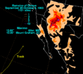
| Octave | Tropical storm | 1983 | Tropical storm | September 28, 1983 |
| Norbert | Category 4 | 1984 | Tropical depression | September 25, 1984 |
| Polo | Category 3 | 1984 | Remnant low | October 3, 1984 |
| Raymond | Category 3 | 1989 | Tropical depression | October 5, 1989 |
| Boris | Category 1 | 1990 | Remnant low | June 11, 1990 |
| Lester | Category 1 | 1992 | Tropical storm | August 22, 1992 |
| Hilary | Category 3 | 1993 | Remnant low | August 27, 1993 |
| Flossie | Category 1 | 1995 | Remnant low | August 11, 1995 |
| Ismael | Category 1 | 1995 | Remnant low | September 15, 1995 |
| Nora | Category 4 | 1997 | Tropical storm | September 25, 1997 |
| Frank | Tropical storm | 1998 | Remnant low | August 9, 1998 |
| Isis | Category 1 | 1998 | Remnant low | September 5, 1998 |
| Olivia | Tropical storm | 2000 | Remnant low | October 11, 2000 |
| Juliette | Category 4 | 2001 | Remnant low | October 3, 2001 |
| Ignacio | Category 2 | 2003 | Remnant low | August 25, 2003 |
| Marty | Category 2 | 2003 | Remnant low | September 22, 2003 |
| Javier | Category 4 | 2004 | Remnant low | September 20, 2004 |
| Emilia | Tropical storm | 2006 | Remnant low | July 25, 2006 |
| John | Category 4 | 2006 | Remnant low | September 5, 2006 |
| Henriette | Category 1 | 2007 | Remnant low | September 6, 2007 |
| Dolly | Category 2 | 2008 | Remnant low | July 28, 2008 |
| Julio | Tropical storm | 2008 | Remnant low | August 25, 2008 |
| Jimena | Category 4 | 2009 | Remnant low | September 5, 2009 |
| Norbert | Category 3 | 2014 | Remnant low | September 8, 2014 |
| Odile | Category 4 | 2014 | Remnant low | September 17, 2014 |
| Newton | Category 1 | 2016 | Remnant low | September 7, 2016 |
| Rosa | Category 4 | 2018 | Tropical depression | October 2, 2018 |
| Sergio | Category 4 | 2018 | Tropical depression | October 13, 2018 |
| Hilary | Category 4 | 2023 | Tropical depression | August 20, 2023 |
Early Storms (Before 1960)
| Precipitation | Storm | Location | Ref. | ||
|---|---|---|---|---|---|
| Rank | mm | in | |||
| 1 | 344.4 | 13.56 | Unnamed 1951 | Crown King | |
| 1 | 305.1 | 12.01 | Nora 1997 | Harquahala Mountains | |
| 2 | 304.8 | 12.00 | Octave 1983 | Mount Graham | |
| 3 | 289.6 | 11.40 | Norma 1970 | Workman Creek | |
| 4 | 210.8 | 8.30 | Heather 1977 | Nogales | |
| 5 | 209.8 | 8.26 | Unnamed 1926 | Hereford | |
| 6 | 178.6 | 7.03 | Unnamed 1939 | Wikieup | |
| 7 | 178.1 | 7.01 | Doreen 1977 | Yuma Valley | |
| 8 | 177.8 | 7.00 | Javier 2004 | Walnut Creek | |
| 9 | 166.9 | 6.57 | Newton 2016 | Rincon Mountains | |
| 10 | 158.8 | 6.25 | Norbert 2014 | Tempe 3.1 WSW | |
Records of tropical cyclones before 1950 are not very detailed. Still, several storms brought rain to Arizona during this time.
- August 1921: The first known tropical storm to affect Arizona was a leftover storm. It moved into the western parts of the state.
- September 1921: A tropical depression traveled along the Mexican coast and then moved into Arizona. It caused heavy rain on September 30. Over 3 inches (76 mm) of rain fell in the Colorado River valley, with Yuma reporting 3.65 inches (93 mm).
- September 1926: Five years later, another September storm's leftovers hit the state. This time, the heaviest rain was in southeastern Arizona. The 1926 storm caused over 5 inches (127 mm) of rain near Douglas.
- June 1929: A rare Atlantic hurricane reached eastern Arizona as a tropical depression. Any damage from this storm is not known.
- August 1935: The leftovers of an unnamed tropical storm hit Southern California. This caused heavy rain and floods across Arizona, especially along the Santa Cruz River. This rain helped make August 1935 the wettest August on record for Tucson.
- August 1951: Moisture from a hurricane that hit Baja California moved over Arizona. It brought over 5 inches (127 mm) of rain to southwestern Arizona. The storm also washed out roads near Gila Bend. This caused about $750,000 (1951 USD) in damage.
Storms in the 1960s
- September 1962: Leftover moisture from Tropical Storm Claudia caused severe flash floods near Tucson. Some areas saw 5 to 7 inches (127 to 178 mm) of rain in just 14-15 hours. The floods affected the Santa Cruz River and its smaller streams. The towns of Marana and Sells were flooded. Total damage in Pima and Pinal Counties was over $11 million (1962 USD).
- September 1964: Tropical Storm Tillie stayed at sea, but its moisture moved over southern Arizona. This caused widespread showers and thunderstorms. Tucson received 3.05 inches (77 mm) of rain in 24 hours.
- August 1967: Hurricane Katrina brought heavy rain to southern Arizona as a tropical depression. Wellton recorded 4.78 inches (121 mm) of rain. Yuma saw 1.88 inches (48 mm) in 24 hours, which was more than its usual fall season rainfall.
- October 1968: Hurricane Pauline added a lot of moisture to the air. This led to severe thunderstorms, including an F2 tornado in Glendale. The tornado damaged homes and caused $250,000 (1968 USD) in damage.
Storms in the 1970s
- September 1970: The leftovers of Tropical Storm Norma contributed to Arizona's deadliest storm, known as the "Labor Day storm of 1970." Much of southern and central Arizona saw 2 to 5 inches (51 to 127 mm) of rain. Mountainous areas received 8 to 11.4 inches (203 to 290 mm). This caused widespread flash flooding, which sadly led to 23 deaths and significant damage.
- October 1971: Hurricane Olivia brought over 2 inches (51 mm) of rain across Arizona. This triggered flash flood warnings. The rain damaged roads, bridges, and homes in Navajo and Pinal counties. This cost about $250,000 in repairs for the state.
- October 1972: Hurricane Joanne entered Arizona as a tropical storm. Many areas received 1 to 3 inches (25 to 76 mm) of rain. The Nogales Highway Bridge was washed away by flooding. The heavy rain made the ground very wet for a later storm, which caused $10 million (1972 USD) in damage and eight deaths.
- September 1976: Hurricane Kathleen entered southern California. It brought strong winds to western and southern Arizona. Yuma reported winds of 57 mph (92 km/h) and gusts of 76 mph (122 km/h). The winds caused one death when a palm tree fell on a mobile home.
- August 1977: Hurricane Doreen caused severe flooding in Yuma County. A rain gauge near Yuma saw over 7 inches (178 mm) of rain.
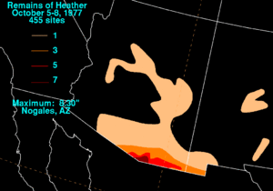
- October 1977: The leftovers of Hurricane Heather brought 8.30 inches (211 mm) of rain to Nogales. Rivers overflowed, forcing 400 people to leave their homes. Total damage from the storm was about $15 million (1977 USD).
Storms in the 1980s
The 1980s also saw destructive tropical storms in Arizona.
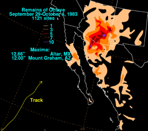
- October 1983: A weather system, including moisture from Tropical Storm Octave, caused huge amounts of rain over ten days. Mount Graham received 12 inches (305 mm) of rain. This caused record floods in several rivers. The Santa Cruz River flooded an area over 8 miles (13 km) wide. Sadly, fourteen people died, and about 10,000 people lost their homes. The damage was estimated at $370 million.
- September 1984: Hurricane Norbert entered Arizona as a weakening tropical depression. Most areas reported 1 to 2 inches (25 to 51 mm) of rain.
- October 1989: Flash floods from Hurricane Raymond caused $1.5 million (1989 USD) in damage. Raymond passed over Arizona as a tropical depression. It brought heavy rain to southeastern Arizona, with Nogales getting 4.72 inches (120 mm). Many streets in Willcox were flooded with up to 2 feet (0.6 m) of water.
Storms in the 1990s
Several tropical systems affected Arizona in the 1990s, even after they lost their tropical strength. However, two hurricanes were strong enough to reach Arizona as tropical systems.
- June 1990: Moisture from Boris brought 3.28 inches (83 mm) of rain to the Santa Rita Mountains.
- August 1992: Hurricane Lester reached Arizona as a tropical storm. It caused over 5 inches (127 mm) of rain near Phoenix and Tucson. The center of Lester passed near Tucson, bringing winds of 31 mph (50 km/h) and gusts up to 45 mph (72 km/h).
- August 1993: Hilary's leftovers caused flash flooding in Pima County after 3.75 inches (95 mm) of rain fell in Green Valley.
- August 1995: Flossie's leftovers dumped over 3 inches (76 mm) of rain over Tucson. One person died trying to cross a flooded stream. Damage from the storm in Arizona totaled $5 million (1995 USD).
- September 1997: Hurricane Nora was the second storm to reach Arizona while still a tropical storm. It set the state's 24-hour rainfall record with 11.97 inches (304 mm) in the Harquahala Mountains. This caused flash flooding. Nora also caused 12,000 people in Yuma to lose power. Nora is thought to be the strongest tropical storm to hit Arizona, with winds of 50 to 60 mph (80 to 97 km/h) over Yuma. It caused $150–200 million (1997 USD) in farm losses.
- September 1998: Isis's leftovers dropped over 2 inches (51 mm) of rain across southern Arizona. This led to some flash flood warnings and flooded roads.
Storms in the 2000s
In the 2000s, no storms reached Arizona while still being full tropical storms. However, many leftover storms caused heavy rain and floods.
- October 2000: The leftovers of Tropical Storm Olivia caused heavy flash floods. Even though Olivia had weakened far away, its leftovers brought widespread heavy rains. Most of southeastern Arizona saw 1.5 to 4 inches (38 to 102 mm) of rain.
- August 2003: The leftovers of Hurricane Ignacio brought rain to southern Arizona. About 40 homes in Catalina were evacuated due to flash flood risks.
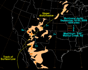
- September 2004: Javier brought heavy rain across the state. This helped with a long drought in the Southwestern United States. The heaviest rain was 7 inches (178 mm) at Walnut Creek. The rain flooded several roads in Tucson.
- July 2006: The leftovers of Tropical Storm Emilia brought a lot of tropical moisture to Arizona. This caused a week of stormy weather. On July 25, a slow-moving thunderstorm dropped several inches of rain in a few hours. This closed Interstate 19 when a wash flooded the road. After a week of widespread rain, major flooding began. Mount Lemmon saw 11.10 inches (282 mm) of rain in 7 days. The floods caused $4 million (2006 USD) in damage.
- September 2007: Hurricane Henriette also caused flooding in Cochise County. Sadly, one woman died trying to cross a flooded wash.
- July 2008: The leftovers from Atlantic hurricane Hurricane Dolly caused rain in eastern Arizona.
- August 2008: Moisture from Tropical Storm Julio caused thunderstorms across Arizona. One storm near Chandler had winds of 75 mph (121 km/h). This storm damaged ten small planes and a hangar at Chandler Municipal Airport. The damage at the airport was about $1 million (2008 USD).
- September 2009: The leftovers of Hurricane Jimena moved over Arizona. Water, rocks, and debris covered many roads. Golf ball-sized hail fell northwest of Golden Valley. In Riviera, seven mobile homes were damaged by 80 mph (129 km/h) wind gusts. Four people were hurt, and damage was $500,000. Mudslides north of Mohave Valley destroyed two homes.
Storms in the 2010s
- September 8, 2014: The leftovers of Hurricane Norbert brought record-breaking rain to central Arizona. Chandler received 6.09 inches (155 mm) of rain. Phoenix Sky Harbor Airport recorded 3.30 inches (84 mm) of rain in seven hours. This broke a 75-year-old daily rainfall record. Two women died after being swept away by floodwaters in their cars. Total damage in Maricopa and La Paz Counties was $17.4 million.
- September 18, 2014: The leftovers of Hurricane Odile brought heavy rain to southeastern Arizona.
- June 5, 2015: The leftovers of Hurricane Andres brought thunderstorms to Arizona. Phoenix had measurable rain that day for the first time since records began in 1896.
- June 9, 2015: Just four days after Andres, another system with leftovers from Hurricane Blanca brought more record-breaking rain to many Arizona cities, including Tucson and Yuma.
- July 18, 2015: Some of Hurricane Dolores's moisture was directed into Arizona. This brought showers and thunderstorms. Up to 1 inch (25 mm) of rain fell in some places. The heavy rain caused flash floods and mudslides near Phoenix.
- October 1–2, 2018: Hurricane Rosa, which was a tropical storm at the time, brought massive rainfall. More than 2 inches (51 mm) of rain was recorded in some places. Many areas were covered with water, and some flash floods occurred.
Storms in the 2020s
- August 18–22, 2023: Hurricane Hilary's leftovers caused heavy rainfall. The highest amount was 2.10 inches (53 mm) at Hilltop.
See also
- List of Pacific hurricanes
- Pacific hurricane season
- List of California hurricanes
- List of New Mexico hurricanes
- List of wettest tropical cyclones in the United States
Images for kids


