
Isla de Mona facts for kids
|
Nickname: Amona
|
|
|---|---|

Satellite Image
|
|

Mona Island
Location in Puerto Rico
|
|
| Geography | |
| Coordinates | 18°5′12″N 67°53′22″W / 18.08667°N 67.88944°W |
| Area | 57 km2 (22 sq mi) |
| Length | 11 km (6.8 mi) |
| Width | 7 km (4.3 mi) |
| Administration | |
|
United States
|
|
| Commonwealth | Puerto Rico |
| Municipality | Mayagüez |
| Barrio | Isla de Mona e Islote Monito |
| Demographics | |
| Population | 5 (2010) |
| Designated: | December 17, 1993 |
| Reference #: | 93001398 |
| Designated: | 1975 |
Mona Island (Spanish: Isla de Mona) is the third-largest island in Puerto Rico. It's smaller than the main island of Puerto Rico and Vieques. Mona Island is found in the Mona Passage, a water channel between the Dominican Republic and Puerto Rico. The other islands in this passage are Monito Island and Desecheo Island.
Mona Island is about 7 miles (11 km) long and 4 miles (7 km) wide. It lies about 41 miles (66 km) west of Puerto Rico. Even though it's far, it's part of the Mayagüez area in Puerto Rico.

The island is a special protected area called the Mona and Monito Islands Nature Reserve. No one lives there permanently. Only rangers and scientists from the Puerto Rico Department of Natural and Environmental Resources stay on the island. They manage visitors and do important research. Mona and Monito Islands are also a National Natural Landmark. This means their amazing natural environment and history are protected. The island is home to unique animals like the Mona ground iguana. It's also a very important place for seabirds.
Mona Island's Past
Who Lived on Mona Island First?
People believe that the first inhabitants of Mona Island were Arawak Indians. They came from Quisqueya, which is now Hispaniola (Haiti and the Dominican Republic). In the 1980s, archaeologists found many ancient objects on the island. These discoveries helped historians learn about the first people who lived there. Stone tools found in a rock shelter are about 5,000 years old (from around 3000 BC). Later, the Taíno people settled on the island. They lived there until the Spanish arrived in the 1400s.


When Europeans Arrived
On November 19, 1493, Christopher Columbus sailed to the New World for the second time. He found the island that is now Puerto Rico. The native people called it Borinquen. Columbus named it San Juan Bautista. After visiting Puerto Rico, Columbus sailed west towards Hispaniola. He was looking for crew members he had left there from his first trip.
As he left Puerto Rico, he reportedly saw Mona Island on September 24, 1494. Spain then claimed the island. The name Mona comes from the Taíno name Ámona. This name honored the island's chief, or Cacique. Some historians think Columbus might have seen Desecheo Island instead, because of his travel path.
In 1502, Fray Nicolás de Ovando was sent to Mona Island. He was supposed to watch the native revolts happening in Hispaniola from a safe distance. Ovando brought about 2,000 Spanish settlers to create a permanent town. But the island was too small for so many people. Food became scarce because supplies from Hispaniola and Puerto Rico didn't arrive often enough.
Juan Ponce de León, who traveled with Columbus, later became the first governor of Puerto Rico.
Mona Island as a Trade Stop
In 1515, King Ferdinand II of Spain took control of Mona Island from Diego Colón. By then, Mona Island was an important stop for trade between Spain and Latin America. It was also a place for ships carrying slaves to rest. King Ferdinand II gave the Taíno people on the island two choices. They could work by fishing, making hammocks, and growing plants. Or, they could become miners, digging for guano and other minerals. Most chose to be fishermen and farmers. This way, they didn't have to pay taxes and avoided hard mining work. Later, natives from other islands were brought to Mona to help with labor.
After King Ferdinand II died in 1516, the island's ownership changed. By 1524, the island was almost empty. Many Taínos had left with Francisco de Barrionuevo, a landlord who exiled himself to South America.
Pirates and Guano Mining
By 1522, ships from England, France, and the Netherlands started visiting Mona Island. They would stop to get supplies for their long trips across the Atlantic Ocean. The island also became a safe place for pirates. From Mona, they could attack and rob Spanish ships.
In 1561, there was a suggestion to make Mona Island part of the Santo Domingo colony (now the Dominican Republic). People thought it was closer to Santo Domingo and its small population could help with farming. But this idea was rejected. Mona Island stayed part of Puerto Rico.
In 1583, the Spanish archbishop of Puerto Rico got permission to bring Christianity to Mona Island. However, by this time, most Taínos had either died or moved to mainland Puerto Rico. This was due to repeated attacks by European ships, especially French ones. From the late 1500s to the mid-1800s, the island was mostly left alone by the Spanish. It was still used by pirates and privateers, including the famous Captain Kidd in 1699.
Things changed in the mid-1800s when people started mining guano on the island. Guano is bat and seagull droppings, which was valuable as fertilizer and for making gunpowder. Mining continued until 1927.
Mona Island's Caves
Mona Island has about 200 caves. Inside, you can find thousands of ancient native art designs. There are also marks and names left by early Spanish explorers.


Mona Island in the 1900s

After the 1898 Treaty of Paris, Mona Island, like the rest of Puerto Rico, became part of the United States. The Mona Island Lighthouse, which was unfinished since the Spanish–American War, was completed in 1900. It started working and guided ships. Many people thought the famous French engineer Gustave Eiffel designed it. But it was actually designed by Spanish engineer Rafael Ravena in 1886. The lighthouse worked until 1976, when a new automated light replaced it.
On December 22, 1919, the island was named an "Insular Forest of Puerto Rico."
During the Prohibition Era, when alcohol was illegal, Mona Island was a place for rum runners. Its location made it perfect for smuggling rum and other liquor. In 1923, customs officials found a hidden stash of liquor, drugs, and perfumes in a cave.
In 1942, during World War II, a German submarine attacked the southern coast of the island. This was one of the few war incidents in the Caribbean. From 1945 to 1955, the United States Air Force used Mona Island for military exercises.
Since 1941, people have also used the island for camping and hunting goats and wild boar. In 1960, a small ranger station was set up to watch over the island. The Puerto Rico Department of Natural and Environmental Resources runs it.
In 1972, scientists studied Mona and Monito Islands. They created a report about the climate, geology, animals, and plants. This was done because there was interest in developing the islands.
In 1981, the Mona Island Lighthouse was added to the U.S. National Register of Historic Places.
On February 15, 1985, a ferry called MV A Regina got stuck on a reef on the southeast side of Mona Island. No one died or was seriously hurt. All 143 passengers and 72 crew members landed on Mona Island and waited for rescue. The ship was removed from the reef in 1990.
In 1993, the island was listed on the National Register as "Isla de la Mona."
Mona Island's Nature
Where is Mona Island?
Mona Island covers about 22 square miles (57 km²). It is about 41 miles (66 km) west of Puerto Rico's main island. It's also about 38 miles (61 km) east of the Dominican Republic. Desecheo Island is about 30 miles (49 km) northeast of Mona.
The Puerto Rican government has made Mona Island an ecological reserve. This means no one lives there permanently. The U.S. census in 2000 reported zero people living there. Mona Island is a barrio (a type of district) of Mayagüez. Monito Island, which is 3 miles (5 km) northwest, is also part of this barrio. This barrio is the largest part of Mayagüez by area.
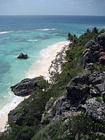
Mona Island's Landscape
Mona Island is mostly a flat area surrounded by tall sea cliffs. It is made of dolomite and limestone. Many caves are found all over the island. The island has a dry climate and has not been changed by human development. Many endemic species live here. Endemic means they are found only in this specific place. One example is the Mona ground iguana (Cyclura cornuta stejnegeri). Mona Island's land, animals, and history are similar to Navassa Island. Navassa is a small limestone island between Jamaica and Haiti.
What Grows on Mona Island?
There are four main types of plant cover on Mona Island:
- Cactus (about 4.35 square miles or 11.27 km²)
- Highland Forest (about 15.55 square miles or 40.28 km²)
- Central Depression Forest (about 0.57 square miles or 1.47 km²)
- Coastal Forest (about 1.45 square miles or 3.77 km²)
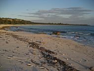
Mona Island's Beaches
Mona Island's beaches are very important for hawksbill sea turtles. Over 1,500 nests are laid on its beaches every year. The island is one of the most important places for hawksbill nesting in the Caribbean and Western Atlantic. Other important nesting sites are in Mexico, Barbados, Panama, and Brazil.


-
Escalera
-
Mujeres
-
Pajaros
-
Sardinera


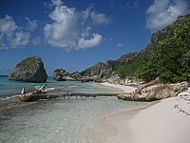
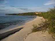
Mona Island has many beaches. Here are some of them:
- Southeast beaches: Playa Escalera, Playa Pájaros, Playa Brava, Playa Coco, Playa Caigo
- Southwest beaches: Playa Uvero-1, Playa Uvero-2, Playa U-8, Playa U-1, Playa Carabinero, Playa Mujeres, Playa Carite
- Western beaches: Playa Sardinera, Playa Carmelitas

The only places where you can camp are at Playa de Pájaros and Playa Sardinera. Other important beaches for visitors include Playa Uveros, Playa Mujeres, and Playa Brava.
Mona Island Today


Today, Mona Island is a special place for people who love nature. Many Puerto Ricans and nature fans from all over the world visit. It's also a popular spot for Boy and Girl Scouts. Because of its unique landscape, animals, and location, Mona, Desecheo, and Monito Islands are sometimes called "The Galápagos Islands of the Caribbean."
Scientists, ecologists, and students come to Mona Island to study its special ecosystem. This includes the Mona ground iguana, which lives only on this island. You can also see many cave drawings left by the island's first inhabitants. Remains of the old guano mining industry are still there too.
Getting to Mona Island
The Puerto Rican government built an airport on Mona Island. It can handle small planes. The United States Coast Guard can fly helicopters from Rafael Hernández Airport in Aguadilla. They help with medicines and first aid, and for emergencies that need hospital care. Private and commercial planes need a special permit from the Puerto Rico Department of Natural and Environmental Resources to use the airport.
Most people travel to Mona Island by private yacht. There are also commercial trips available from Cabo Rojo for small groups.
Activities on Mona Island
Hunting is allowed during certain seasons. This helps control the number of non-native animals like goats and wild boars. These animals can harm the island's endangered species. The hunting season usually runs from December to April. Camping is allowed from May through November.
Because Mona Island is so important naturally and culturally, the Puerto Rican government is interested in making it a UNESCO World Heritage Site. This would help protect it even more.
Images for kids
-
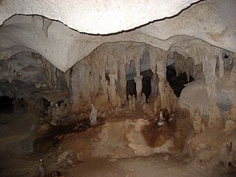
Mona Island cave
-
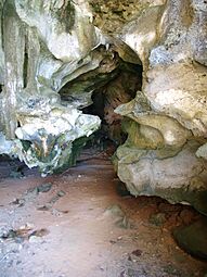
Cueva del Diamante on Isla Mona
-
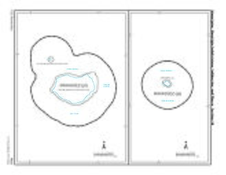
US 2010 Census map of the two islands (Isla de Mona) and (Monito Island)
-
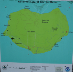
Mona overview map
-
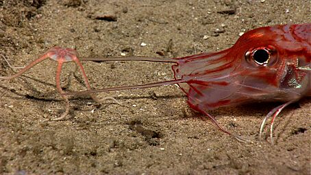
Armored sea robin with brittle star


See also
 In Spanish: Isla Mona para niños
