Montcalm County, Michigan facts for kids
Quick facts for kids
Montcalm County
|
|
|---|---|

|
|

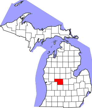
Location within the U.S. state of Michigan
|
|
 Michigan's location within the U.S. |
|
| Country | |
| State | |
| Founded | 1738 (created) 1850 (organized) |
| Named for | Louis-Joseph de Montcalm |
| Seat | Stanton |
| Largest city | Greenville |
| Area | |
| • Total | 721 sq mi (1,870 km2) |
| • Land | 705 sq mi (1,830 km2) |
| • Water | 15 sq mi (40 km2) 2.1%% |
| Population
(2020)
|
|
| • Total | 66,614 |
| • Density | 90/sq mi (30/km2) |
| Time zone | UTC−5 (Eastern) |
| • Summer (DST) | UTC−4 (EDT) |
| Congressional district | 2nd |
Montcalm County is a county located in the state of Michigan in the United States. In 2020, about 66,614 people lived here.
You can find Montcalm County in the western part of Michigan's Lower Peninsula. The main town, called the county seat, is Stanton. The biggest city in the county is Greenville.
The county gets its name from General Marquis Louis-Joseph de Montcalm. He was a French military leader during the French and Indian War. Montcalm County was first created in 1831 and officially started operating in 1850. It is part of the larger Grand Rapids metropolitan area.
Contents
Geography of Montcalm County
Montcalm County covers a total area of about 721 square miles. Most of this area, 705 square miles, is land. The remaining 15 square miles, which is about 2.1%, is water.
Neighboring Counties
Montcalm County shares borders with several other counties:
- Isabella County (to the northeast)
- Mecosta County (to the north)
- Gratiot County (to the east)
- Newaygo County (to the west)
- Ionia County (to the south)
- Kent County (to the southwest)
- Clinton County (to the southeast)
Protected Natural Areas
A part of the Manistee National Forest is located within Montcalm County. This is a large area of protected land.
Main Roads
Several important highways run through Montcalm County, making it easy to travel around:
 US 131
 M-46
M-46 M-57
M-57 M-66
M-66 M-82
M-82 M-91
M-91
People of Montcalm County
The number of people living in Montcalm County has grown over the years. Here's how the population has changed:
| Historical population | |||
|---|---|---|---|
| Census | Pop. | %± | |
| 1850 | 891 | — | |
| 1860 | 3,968 | 345.3% | |
| 1870 | 13,629 | 243.5% | |
| 1880 | 33,148 | 143.2% | |
| 1890 | 32,754 | −1.2% | |
| 1900 | 32,754 | 0.0% | |
| 1910 | 32,069 | −2.1% | |
| 1920 | 30,441 | −5.1% | |
| 1930 | 27,471 | −9.8% | |
| 1940 | 28,581 | 4.0% | |
| 1950 | 31,013 | 8.5% | |
| 1960 | 35,795 | 15.4% | |
| 1970 | 39,660 | 10.8% | |
| 1980 | 47,555 | 19.9% | |
| 1990 | 53,059 | 11.6% | |
| 2000 | 61,226 | 15.4% | |
| 2010 | 63,342 | 3.5% | |
| 2020 | 66,614 | 5.2% | |
| 2023 (est.) | 68,154 | 7.6% | |
| U.S. Decennial Census 1790-1960 1900-1990 1990-2000 2010-2018 |
|||
In 2000, there were about 61,266 people living in the county. Most people in Montcalm County are White. There are also smaller groups of Black or African American, Native American, and Asian people. Some residents are also of Hispanic or Latino background.
Many families live in Montcalm County. About 35% of households had children under 18 living with them. The average household had about 2.65 people.
The median age of people in the county was 36 years old. This means half the people were younger than 36 and half were older. About 27% of the population was under 18 years old.
Communities in Montcalm County
Montcalm County has several towns and cities where people live.
Cities
- Carson City
- Greenville
- Stanton (This is the county seat, the main town for county government)
Villages
Census-Designated Places
These are areas that are like towns but are not officially incorporated as cities or villages.
Other Small Communities
Townships
Townships are smaller local government areas within the county.
- Belvidere Township
- Bloomer Township
- Bushnell Township
- Cato Township
- Crystal Township
- Day Township
- Douglass Township
- Eureka Charter Township
- Evergreen Township
- Fairplain Township
- Ferris Township
- Home Township
- Maple Valley Township
- Montcalm Township
- Pierson Township
- Pine Township
- Reynolds Township
- Richland Township
- Sidney Township
- Winfield Township
Education in Montcalm County
Montcalm County offers many places for learning, from libraries to schools and colleges.
Libraries
There are nine libraries in the county where you can find books and information:
- Montcalm Community College Library
- Carson City Public Library
- Crystal Community Library
- Flat River Community Library
- Home Township Library
- Reynolds Township Library
- Richland Township Library
- Tamarack District Library
- White Pine Library
School Districts
The county has eight public school districts that serve students from kindergarten through high school:
- Carson City Crystal Area School District
- Central Montcalm Public Schools
- Greenville Public Schools
- Lakeview Public Schools
- Montabella Community Schools
- Montcalm Area ISD
- Tri County Area Schools
- Vestaburg Community Schools
Community College
For students who want to continue their education after high school, Montcalm County has one community college:
- Montcalm Community College
See also
 In Spanish: Condado de Montcalm (condado de Montcalm, Míchigan) para niños
 | James Van Der Zee |
 | Alma Thomas |
 | Ellis Wilson |
 | Margaret Taylor-Burroughs |

