
Mount Price (British Columbia) facts for kids
Quick facts for kids Mount Price |
|
|---|---|
| Red Mountain Clinker Mountain |
|

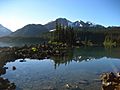
Mount Price and one of the Battleship Islands reflected in the clear water of Garibaldi Lake
|
|
| Highest point | |
| Elevation | 2,052 m (6,732 ft) |
| Prominence | 402 m (1,319 ft) |
| Geography | |

Mount Price
Location in British Columbia
|
|
| Parent range | Garibaldi Ranges |
| Topo map | NTS 92G/14 |
| Geology | |
| Mountain type | Stratovolcano |
| Volcanic arc/belt | Canadian Cascade Arc Garibaldi Volcanic Belt |
| Last eruption | 15,000–12,000 years ago |
Mount Price is a volcano in southwestern British Columbia, Canada. It is a type of volcano called a stratovolcano, which means it's shaped like a cone. Mount Price is part of the Garibaldi Ranges and stands tall above Garibaldi Lake.
This mountain is about 10 km (6.2 mi) southeast of a place called Garibaldi. Its highest point is 2,052 m (6,732 ft) above sea level. Mount Price is surrounded by a large provincial park that protects it and other nearby volcanoes.
Smaller volcanoes like Clinker Peak are found on Mount Price's northern and western sides. These smaller volcanoes formed from eruptions that came from different openings, not just the main one. This means Clinker Peak is actually considered part of Mount Price.
Mount Price is part of a group of volcanoes called the Garibaldi Lake volcanic field. This field is part of a bigger volcanic area known as the Garibaldi Volcanic Belt. Mount Price started forming about 1.2 million years ago. It last erupted between 15,000 and 12,000 years ago. Even though it hasn't erupted recently, it could erupt again. If it did, groups like the Interagency Volcanic Event Notification Plan (IVENP) are ready to warn people.
Contents
Understanding Mount Price's Geology
Mount Price is one of three main volcanoes in the southern part of the Garibaldi Volcanic Belt. Unlike many other volcanoes in Canada, Mount Price has a very even shape. It is one of several volcanoes in the Garibaldi Belt that have been active in the last 2.6 million years, a time period called the Quaternary period.
Clinker Peak, a broken volcanic crater on Mount Price's western side, formed about 10,000 years ago. The rocks on Mount Price have turned red because of a process called oxidation. This is like when metal rusts.
Mount Price, like other volcanoes in the Garibaldi Volcanic Belt, formed because of plate tectonics. The Juan de Fuca Plate is slowly sliding under the North American Plate. This process is called subduction. As one plate slides under another, it can create volcanoes and cause eruptions.
Scientists know this process is still happening because of the active volcanoes in the area. The speed at which these plates move has slowed down over millions of years. This slower movement might explain why there are fewer earthquakes and no deep ocean trench in this area.
Mount Price's Volcanic History
Mount Price has had at least three periods of eruptions. The first one happened about 1.2 million years ago. During this time, lava and volcanic rocks filled a basin that was shaped by glaciers. The Black Tusk, another volcano about 5 km (3.1 mi) north of Mount Price, was also active then. This is the oldest known eruption in the Garibaldi Lake volcanic field.

Around 300,000 years ago, during the Middle Pleistocene period, the volcanic activity moved west. This is when Mount Price itself formed, becoming the nearly symmetrical volcano we see today. It had many eruptions that produced different types of lava and fast-moving flows of hot gas and rock. Later, a huge ice sheet called the Cordilleran Ice Sheet covered the volcano during an Ice age.
After the Cordilleran Ice Sheet melted away from the higher areas less than 15,000 years ago, new eruptions happened. Lava erupted from a side vent at Price Bay, forming a small lava dome or scoria cone. Around the same time, Clinker Peak erupted two thick lava flows. These flows were at least 300 m (980 ft) thick and 6 km (3.7 mi) long. They were so thick because they cooled against the melting Cordilleran Ice Sheet, which still filled the valleys.
One of these lava flows created a natural dam called The Barrier. This dam holds back the water of Garibaldi Lake. The Barrier has caused two large landslides in the past. The most recent big landslide was in 1855-1856. It sent 30,000,000 m3 (1.1×10⁹ cu ft) of rock sliding 6 km (3.7 mi) down to the Cheakamus valley. The other lava flow formed a ridge called Clinker Ridge.
Unlike some other volcanic areas, there are no known hot springs around Garibaldi Lake. However, there is evidence of high heat underground near Mount Price. This suggests that hot rock (magma) is still present beneath the area, likely from recent volcanic activity.
Mount Price and People
How Mount Price Got Its Name

Mount Price has had a few names over time. It was first called Red Mountain because of its reddish color. However, to avoid confusion with another peak, its name was changed.
In 1927, a Canadian scientist named William Henry Mathews called it Clinker Mountain. But on September 2, 1930, the name Mount Price was officially chosen. It was named after Thomas E. Price, who was a mountaineer and engineer for the Canadian Pacific Railway. The names Clinker Peak and Clinker Ridge were kept to remember the earlier name, Clinker Mountain.
Protecting and Watching the Volcano
Mount Price and its volcanic features are protected within Garibaldi Provincial Park. This large wilderness park was created in 1927 and covers an area of 194,650 ha (481,000 acres). Many other volcanoes, like Mount Garibaldi and The Black Tusk, are also in the park.
Garibaldi Provincial Park is about 70 km (43 mi) north of Vancouver. It has many different plants, clear waters, and a rich geological history. You can also find lots of wildlife there, such as squirrels, chipmunks, Canada jays, and flickers. The park is named after Mount Garibaldi, which was named after an Italian hero, Giuseppe Garibaldi.
Scientists don't watch Mount Price as closely as some other volcanoes to see how active its magma system is. The Canadian National Seismograph Network monitors earthquakes across Canada. While it might detect a big increase in activity if Mount Price became very restless, it might only give a warning once an eruption has already started.
If Mount Price were to erupt, plans are in place to help people. The Interagency Volcanic Event Notification Plan (IVENP) helps different agencies work together. They would notify people threatened by an eruption in Canada or near the Canada–United States border.
Volcanic Dangers and Effects
Over the last 1.3 million years, there have been at least 63 volcanic events in the Garibaldi Lake volcanic field. There haven't been any eruptions since the early Holocene epoch (about 11,700 years ago). Future eruptions from Mount Price would likely be similar to past ones.
In Canada, there's a chance of an eruption about once every 200 years. For a slow lava flow, it's about once every 220 years. For a large, explosive eruption, it's about once every 3,333 years. This means that if Mount Price erupts, it's more likely to be a slow lava flow than a huge explosion. However, the Garibaldi Volcanic Belt is known for Canada's most explosive volcanoes, even if eruptions happen less often here.
Potential Effects of an Eruption
Mount Price is close to a highly populated area in British Columbia, so an eruption could affect many people. Even if Mount Price doesn't have the biggest, most explosive eruptions, it can still produce a lot of volcanic ash. This ash could impact nearby towns like Whistler and Squamish.
Mount Price is also near a major air traffic route. Volcanic ash can make it hard to see and can damage jet engines and other aircraft parts. Eruptions could also cause short-term and long-term water supply problems for Vancouver and the surrounding area. The water supply for Greater Vancouver is located downwind from Mount Price.

An eruption could also cause floods and lahars (mudflows). These could damage parts of the Sea to Sky Highway, threaten communities like Brackendale, and endanger water supplies from Pitt Lake. Fisheries on the Pitt River would also be at risk. These dangers become more serious as the population in the Lower Mainland grows.
Since the main type of lava from Mount Price is andesite, lava flows are a low to moderate danger. Andesite lava is thicker than some other types of lava, so it usually moves slower. This means it's less likely to travel very far from the volcano.
Because of concerns about The Barrier being unstable, the provincial government declared the area below it unsafe in 1980. This led to people moving out of the nearby village of Garibaldi. If The Barrier were to collapse completely, Garibaldi Lake would empty out. This would cause major damage downstream in the Cheakamus and Squamish rivers, including to the town of Squamish. It could even create a large wave in Howe Sound that would reach Vancouver Island.
The area prone to landslides is called the Barrier Civil Defence Zone. While large landslides are not expected soon, warning signs are posted there. These signs help visitors know about the potential danger and stay safe. For safety, BC Parks recommends that visitors do not camp, stop, or stay for long in this zone.
Images for kids
-
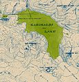
Topographic map of the Garibaldi Lake area depicting Mount Price and adjacent peaks
-
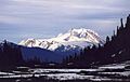
Mount Garibaldi with Mount Price and Clinker Peak in the left-centre
-
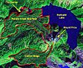
False colour image of Mount Price and associated lava flows
-
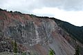
The Barrier is part of a thick lava flow that erupted from Clinker Peak between 15,000 and 8,000 years ago.
-
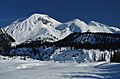
Mount Price with Clinker Peak on the right and the forested Price Bay dome on the left
-
Mount Price and Clinker Peak
-
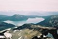
Garibaldi Lake with Mount Price behind on the left

.jpg)


See also
 In Spanish: Monte Price (Columbia Británica) para niños
