Northwest Oregon facts for kids
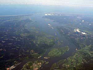
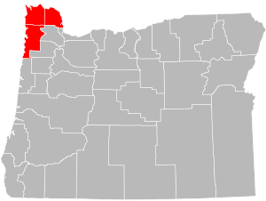
Northwest Oregon is a special part of the U.S. state of Oregon. It includes Clatsop, Columbia, and Tillamook counties. This area is in the northernmost part of Oregon, right along the lower Columbia River.
Contents
History of Northwest Oregon
For thousands of years, the Chinook and Salish peoples Native American tribes lived in this region. They were the first people here.
Early Explorers
In May 1792, an American explorer named Robert Gray was the first European American to sail on the Columbia River. He traded with the Native American tribes. Gray made a map of the lower river. Another explorer, George Vancouver, later explored the river even more, traveling all the way to Mount Hood.

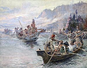
The famous Lewis and Clark Expedition reached the Pacific Ocean on November 7, 1805. They had a tough winter on the north side of the Columbia River. It was cold and stormy, and they didn't have much food. On November 24, 1805, the group decided to move their camp. They moved to the south side of the Columbia River, near where Astoria, Oregon is today.
Fort Clatsop
At this meeting, Sacagawea (a Native American woman who helped the expedition) and York (Clark's enslaved helper) were allowed to vote. This might have been the first time in American history that a woman and an enslaved person were part of such a vote.
On the south side of the river, they built Fort Clatsop. This fort gave them shelter and protection. It also showed that America was claiming this land. During the winter, Meriwether Lewis wrote a lot in his journals. He recorded important information about the plants and forests. Many of the men got sick with colds and the flu during this time.
In 1811, a British explorer named David Thompson reached Fort Astoria. This fort was being built near the mouth of the Columbia River. He arrived just two months after the American ship Tonquin had started building it. Fort Astoria was important because it showed that this area was an American settlement, not British. It became a key spot for American exploration. Later, it helped America claim this land during the Oregon boundary dispute with European countries. Astoria is the oldest place on the Pacific coast that Americans have lived in continuously.
In 1848, this area became part of the Oregon Territory. Then, in 1859, Oregon became a state, and Northwest Oregon became part of it.
Geography of Northwest Oregon

Northwest Oregon is bordered by the Columbia River to the north and east, which separates it from Washington. To the west is the Pacific Ocean. The rest of Oregon is to the southeast. Saddle Mountain is the highest mountain in this region. It is 3,288 feet tall. This mountain is part of the Oregon Coast Range, which covers most of the inner part of the region.
Counties in Northwest Oregon
Usually, these three counties are considered part of Northwest Oregon:
- Clatsop County (population 37,831)
- Columbia County (population 49,600)
- Tillamook County (population 25,653)
Sometimes, parts of Washington County are also included. The total population of this region is about 113,084 people.
Cities in Northwest Oregon
| City | County | Population (2015) |
|---|---|---|
| St. Helens | Columbia | 13,158 |
| Astoria | Clatsop | 9,626 |
| Scappoose | Columbia | 6,954 |
| Seaside | Clatsop | 6,540 |
| Warrenton | Clatsop | 5,282 |
| Tillamook | Tillamook | 4,997 |
| Vernonia | Columbia | 2,143 |
| Columbia City | Columbia | 1,958 |
| Rainier | Columbia | 1,920 |
| Clatskanie | Columbia | 1,759 |
| Cannon Beach | Clatsop | 1,702 |
| Gearhart | Clatsop | 1,524 |
| Rockaway Beach | Tillamook | 1,347 |
| Bay City | Tillamook | 1,332 |
| Garibaldi | Tillamook | 783 |
| Manzanita | Tillamook | 622 |
| Wheeler | Tillamook | 419 |
| Nehalem | Tillamook | 278 |
| Prescott | Columbia | 49 |
 | Shirley Ann Jackson |
 | Garett Morgan |
 | J. Ernest Wilkins Jr. |
 | Elijah McCoy |


