Rockingham County, Virginia facts for kids
Quick facts for kids
Rockingham County
|
|||
|---|---|---|---|

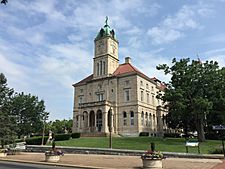
Rockingham County Courthouse in Court Square, Harrisonburg
|
|||
|
|||

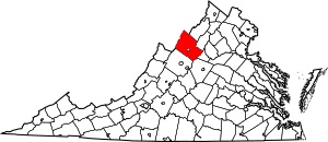
Location within the U.S. state of Virginia
|
|||
 Virginia's location within the U.S. |
|||
| Country | |||
| State | |||
| Founded | 1778 | ||
| Named for | Charles Watson-Wentworth | ||
| Seat | Harrisonburg | ||
| Largest town | Bridgewater | ||
| Area | |||
| • Total | 853 sq mi (2,210 km2) | ||
| • Land | 849 sq mi (2,200 km2) | ||
| • Water | 4.3 sq mi (11 km2) 0.5% | ||
| Population
(2020)
|
|||
| • Total | 83,759 | ||
| • Density | 98.19/sq mi (37.913/km2) | ||
| Time zone | UTC−5 (Eastern) | ||
| • Summer (DST) | UTC−4 (EDT) | ||
| Congressional district | 6th | ||
Rockingham County is a county located in the state of Virginia. In 2020, about 83,757 people lived here. Its main town, or county seat, is Harrisonburg.
Harrisonburg is a special kind of city in Virginia called an independent city. This means it's not officially part of Rockingham County, even though it's the county seat. Rockingham County and Harrisonburg together form the Harrisonburg Metropolitan Statistical Area. The county is also home to the Rockingham County Baseball League.
Contents
History of Rockingham County
Early Settlers and the Shenandoah Valley
People started settling in this area in 1727. A pioneer named Adam Miller was one of the first. He came from Pennsylvania and built a home near the Shenandoah River. He had heard about the beautiful Shenandoah Valley from explorers.
In the 1740s and 1750s, more European settlers arrived. They mostly came from the north, following a path called the Great Wagon Trail. This trail is now known as U.S. Route 11. It was easier to travel this way than to cross the Blue Ridge Mountains from eastern Virginia.
How the County Got Its Name
Rockingham County was officially created in 1778. It was formed from a larger area called Augusta County. Harrisonburg became the county seat in 1780. Later, in 1916, Harrisonburg became an independent city.
The county is named after Charles Watson-Wentworth, 2nd Marquess of Rockingham. He was a British leader who served as Prime Minister twice. He was a strong supporter of the American colonists' rights. During his first time as Prime Minister, he helped get rid of the unpopular Stamp Act of 1765, which had taxed the colonies.
When he became Prime Minister again in 1782, he supported the idea of the Thirteen Colonies becoming independent. This helped end the American Revolutionary War. Sadly, he died just 14 weeks after taking office.
It was unusual to name a place after a British official in 1778, as Virginia was fighting for its independence. For example, a county nearby, Dunmore County, was renamed that same year because its namesake, Governor John Murray, 4th Earl of Dunmore, was not liked. However, the Marquess of Rockingham was very popular with Americans because he had always supported them in the British Parliament. Other places named after him include counties in New Hampshire and North Carolina.
Rockingham County is also famous as the birthplace of Thomas Lincoln, who was Abraham Lincoln’s father.
In 1979, when the Adolf Coors Brewing Company came to Rockingham County, it caused a big discussion. Some people worried it would change the area's values, while others were happy about the new jobs it would bring.
Geography and Nature
Rockingham County covers about 853 square miles. Most of this is land, with a small amount of water. It's the third-largest county in Virginia by land area.
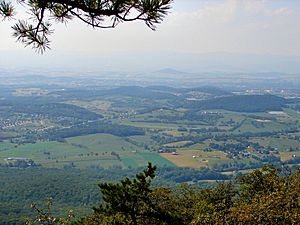
A lot of the county is part of Shenandoah National Park to the east and George Washington National Forest to the west. This means these areas are protected and can't be developed much. The county stretches from the Alleghany mountains in the west to the Blue Ridge Mountains in the east, covering the whole Shenandoah Valley.
A unique mountain range called Massanutten Mountain runs through the middle of Rockingham County. It splits the central Shenandoah Valley. The German River and the North Fork Shenandoah River flow on one side of Massanutten Mountain, while the South Fork flows on the other.
Neighboring Areas
Rockingham County shares borders with several other counties and one independent city:
- Pendleton County, West Virginia – west
- Hardy County, West Virginia – north
- Shenandoah County, Virginia – northeast
- Page County, Virginia – east
- Greene County, Virginia – southeast
- Albemarle County, Virginia – southeast
- Augusta County, Virginia – southwest
- Harrisonburg, Virginia – center (this city is surrounded by the county but is separate)
Protected Natural Areas
- George Washington National Forest (part of it is in the county)
- Shenandoah National Park (part of it is in the county)
People and Population
Population Growth Over Time
The population of Rockingham County has grown a lot over the years. Here's a quick look at how it has changed:
| Historical population | |||
|---|---|---|---|
| Census | Pop. | %± | |
| 1790 | 7,449 | — | |
| 1800 | 10,374 | 39.3% | |
| 1810 | 12,753 | 22.9% | |
| 1820 | 14,784 | 15.9% | |
| 1830 | 20,683 | 39.9% | |
| 1840 | 17,344 | −16.1% | |
| 1850 | 20,294 | 17.0% | |
| 1860 | 23,408 | 15.3% | |
| 1870 | 23,668 | 1.1% | |
| 1880 | 29,567 | 24.9% | |
| 1890 | 31,299 | 5.9% | |
| 1900 | 33,527 | 7.1% | |
| 1910 | 34,903 | 4.1% | |
| 1920 | 30,047 | −13.9% | |
| 1930 | 29,709 | −1.1% | |
| 1940 | 31,289 | 5.3% | |
| 1950 | 35,079 | 12.1% | |
| 1960 | 40,485 | 15.4% | |
| 1970 | 47,890 | 18.3% | |
| 1980 | 57,038 | 19.1% | |
| 1990 | 57,482 | 0.8% | |
| 2000 | 67,725 | 17.8% | |
| 2010 | 76,314 | 12.7% | |
| 2020 | 83,757 | 9.8% | |
| U.S. Decennial Census | |||
Who Lives Here? (2020 Census)
In 2020, the county's population was 83,757. Most people were White (85.21%). Other groups included Black or African American (2.11%), Asian (1.10%), and people of two or more races (2.72%). About 8.47% of the population was Hispanic or Latino (who can be of any race).
Education
Rockingham County has many schools and colleges.
Colleges and Universities
- Bridgewater College in Bridgewater, Virginia
- Eastern Mennonite University in Harrisonburg, Virginia
- James Madison University in Harrisonburg, Virginia
Transportation
Roads and Highways
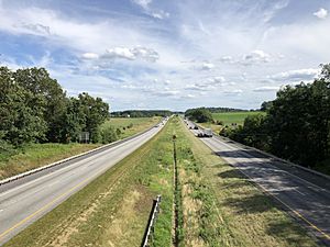
Interstate 81 is a major highway that runs north and south through the county. It connects with Interstate 64 to the south.
There are three other important state highways:
- U.S. Route 11: This road also runs north and south, following an old Native American trail.
- U.S. Route 33: This road goes east and west. It crosses the Shenandoah Valley and climbs the Blue Ridge Mountains. At Swift Run Gap, you can find an entrance to the Skyline Drive (part of Shenandoah National Park) and the Appalachian Trail.
- U.S. Route 340: This road runs north and south along the western side of the Blue Ridge Mountains.
All these main roads are kept up by the Virginia Department of Transportation (VDOT).
Communities in Rockingham County
Rockingham County has several towns and other communities.
Towns
Census-Designated Places (CDPs)
These are areas that are like towns but are not officially incorporated.
Other Communities
Many smaller communities are not officially towns or CDPs. Some of them are:
- Bergton
- Clover Hill
- Cross Keys
- Dale Enterprise
- Fulks Run
- Keezletown
- Linville
- McGaheysville
- Port Republic
- Singers Glen
- Spring Creek
Independent City
- Harrisonburg is the county seat, but it is an independent city and not politically part of Rockingham County.
Law Enforcement
The main law enforcement agency in Rockingham County is the Rockingham County Sheriff's Office (RCSO). They also help keep Harrisonburg safe. The current Sheriff is Bryan F. Hutcheson. The RCSO has received special awards for meeting high professional standards.
See also
 In Spanish: Condado de Rockingham (Virginia) para niños
 | Tommie Smith |
 | Simone Manuel |
 | Shani Davis |
 | Simone Biles |
 | Alice Coachman |


