Santos, São Paulo facts for kids
Quick facts for kids
Santos
|
|||
|---|---|---|---|
|
Municipality
|
|||
| Municipality of Estancia Balneária de Santos | |||
|
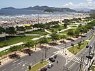
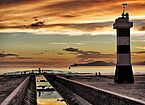
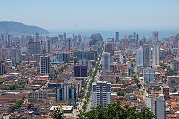
From top left to right: buildings on the edge of town; Monument of the 100 Years of Japanese Immigration in Roberto Mário Santini Park; beach front garden; Channel 6 of the city's drainage system; Ponta da Praia landmark and view of Santos Bay; cargo ship at the entrance to the Port of Santos; and panoramic view of the Santos waterfront.
|
|||
|
|||
| Motto(s):
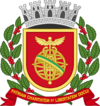
Patriam Charitatem et Libertatem Docui
(Latin: To the homeland I taught charity and liberty) |
|||
 |
|||
| Country | |||
| State | |||
| Government | |||
| • Type | Mayor-council | ||
| Area | |||
| • Municipality | 280.67 km2 (108.37 sq mi) | ||
| Elevation | 2 m (7 ft) | ||
| Population
(2022)
|
|||
| • Municipality | 418,608 | ||
| • Density | 1,491.460/km2 (3,862.86/sq mi) | ||
| • Metro | 1,672,991 | ||
| Demonym(s) | Santista | ||
| Time zone | UTC−3 (BRT) | ||
| Postal code |
11000-000
|
||
| Area code | +55 13 | ||
| HDI (2010) | 0.840 – very high (UNDP) | ||
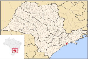
Santos is a city in the Brazilian state of São Paulo. It was founded in 1546 by a Portuguese nobleman named Brás Cubas. Most of Santos is on the island of São Vicente. This island is also home to the city of São Vicente. A smaller part of Santos is on the mainland.
Santos is the main city in the Baixada Santista area. About 418,608 people live here (2022 estimate). The city covers an area of about 280.67 square kilometers. Santos is famous for its Coffee Museum, where coffee prices were once set for the whole world. It also has a special memorial for great football players. This includes Pelé, who played most of his career for Santos FC. The city's beachfront garden is 5,335 meters long. It is listed in Guinness World Records as the largest beachfront garden in the world!
Contents
History of Santos
Early Days of Santos
The island of São Vicente was first mentioned in 1502. This was just two years after Brazil was officially discovered. An expedition led by Amerigo Vespucci explored the Brazilian coast. They named the island São Vicente after a saint.
Later, in 1531, Brazil became more important to Portugal. King D. João III sent Martim Afonso de Sousa to mark out territories. He found a small village and a dock called Porto de São Vicente. A trader named Cosme Fernandes had started this village, and it was growing fast. Martim Afonso took control and gave land to new settlers.
In 1543, a chapel was built by Luís de Góis. Brás Cubas then decided to move the port to a calmer spot called Enguaguaçu. This move helped trade grow a lot. Brás Cubas also built Brazil's second hospital there. It was called Santa Casa de Misericórdia de Todos os Santos. The new town of Enguaguaçu became known as Todos os Santos. Some people think the name Santos came from the port of Santos in Lisbon, Portugal. This new settlement was then called "Vila do Porto de Santos," and later, just "Santos."
Santos in the 1900s
The Port of Santos became very important for exporting coffee. This made the city rich around the start of the 20th century. The port's trade helped Santos become the modern city it is today. It is a vital way for products from São Paulo State to reach the world. The city also has canals that are over a hundred years old. In 1899, Santos faced a health challenge when the bubonic plague arrived in Brazil. In 1924, Santos became the center of the Roman Catholic Diocese of Santos.
In October 2006, oil was found off the coast in the Santos basin. This was an important discovery.
Santos became a popular place for tourists starting in the 1910s. New hotels like the International Hotel and Parque Balneário were built. The famous beachfront gardens were built in 1935. Today, tourism is still one of Santos's main activities. People love its beaches and historical sites.
Geography of Santos
Santos is about 50 kilometers (31 miles) from São Paulo, the state capital. São Paulo is also the biggest city in Brazil.
The city is home to the Laje de Santos Marine State Park. This park was created in 1993. It was the first marine park in the state. Santos has two main geographic areas. One is the heavily built-up island. The other is the continental area. About 70% of the continental area is protected land. These two areas are very different in terms of people, economy, and landscape.
The Island Area
Santos is partly on the island of São Vicente. This island is shared with the nearby city of São Vicente. The island part of Santos is about 39.4 square kilometers. Almost all the city's people live here. It has a flat area near the coast. This area is usually less than twenty meters above sea level. There are also some isolated hills. These hills were once home to both rich and poor families. They are not taller than 200 meters above sea level.
Most of the flat part of the island no longer has its original plants. However, in the northern parts, you can still find some mangrove forests. Before the city grew, this area had large wetlands with mangroves and Atlantic Forest plants.
On the city's hills, you can still see large areas of native Atlantic Forest. Even with some farms and homes, the forest remains. The 'Lagoa da Saudade' (Homesickness Lagoon) is on one of these hills. It was known for having a type of caiman. The lagoon is also a popular spot for families. It has playgrounds, barbecue areas, and green spaces. Building homes on the hills without planning can be risky. Cutting down trees leads to landslides, especially during the rainy season from January to March.
Many rivers on the island were turned into canals. Engineer Saturnino de Brito designed this system. For example, the Dois Rios ("Two Rivers") is now called 'Canal 4'. Other rivers, like the Rio de São Jorge, face pollution problems.
Beaches of Santos
- José Menino Beach
- Pompeia Beach
- Gonzaga Beach
- Boqueirão Beach
- Embaré Beach
- Aparecida Beach
- Ponta da Praia Beach
Islands Near Santos
- Urubuqueçaba Island
- Barnabé Island
- Diana Island
Climate in Santos
Santos is just outside the tropics. However, it has a tropical rainforest climate (Köppen: Af). This means it has no real dry season. Tropical rainforest climates are usually found closer to the equator. All months of the year in Santos get more than 60 mm of rain.
Santos has warm weather all year. June is a bit cooler and drier than January. Average temperatures are around 19 °C in winter. In summer, they are around 25 °C. Santos gets a lot of rain, about 2000 mm each year. It is one of the few places in Brazil outside the Amazon Basin that gets this much rain.
| Climate data for Santos, São Paulo (1981–2010) | |||||||||||||
|---|---|---|---|---|---|---|---|---|---|---|---|---|---|
| Month | Jan | Feb | Mar | Apr | May | Jun | Jul | Aug | Sep | Oct | Nov | Dec | Year |
| Record high °C (°F) | 42.0 (107.6) |
40.3 (104.5) |
38.3 (100.9) |
37.0 (98.6) |
37.0 (98.6) |
34.5 (94.1) |
35.8 (96.4) |
38.7 (101.7) |
40.8 (105.4) |
38.4 (101.1) |
40.3 (104.5) |
40.7 (105.3) |
42.0 (107.6) |
| Mean daily maximum °C (°F) | 29.4 (84.9) |
29.4 (84.9) |
28.3 (82.9) |
27.3 (81.1) |
25.2 (77.4) |
24.1 (75.4) |
23.0 (73.4) |
22.7 (72.9) |
23.0 (73.4) |
24.7 (76.5) |
26.7 (80.1) |
27.9 (82.2) |
26.0 (78.8) |
| Daily mean °C (°F) | 26.3 (79.3) |
26.4 (79.5) |
25.6 (78.1) |
24.3 (75.7) |
22.0 (71.6) |
20.2 (68.4) |
19.3 (66.7) |
19.2 (66.6) |
20.1 (68.2) |
22.0 (71.6) |
24.0 (75.2) |
25.0 (77.0) |
22.9 (73.2) |
| Mean daily minimum °C (°F) | 22.8 (73.0) |
22.9 (73.2) |
22.3 (72.1) |
21.0 (69.8) |
18.7 (65.7) |
16.5 (61.7) |
15.9 (60.6) |
16.0 (60.8) |
17.2 (63.0) |
19.0 (66.2) |
20.8 (69.4) |
21.7 (71.1) |
19.6 (67.3) |
| Record low °C (°F) | 14.6 (58.3) |
14.1 (57.4) |
15.3 (59.5) |
10.0 (50.0) |
8.7 (47.7) |
4.2 (39.6) |
2.0 (35.6) |
4.3 (39.7) |
7.2 (45.0) |
10.4 (50.7) |
8.2 (46.8) |
13.6 (56.5) |
2.0 (35.6) |
| Average precipitation mm (inches) | 206.7 (8.14) |
203.2 (8.00) |
257.3 (10.13) |
180.3 (7.10) |
123.2 (4.85) |
123.1 (4.85) |
102.4 (4.03) |
73.6 (2.90) |
145.1 (5.71) |
137.5 (5.41) |
110.4 (4.35) |
181.1 (7.13) |
1,843.9 (72.59) |
| Average precipitation days (≥ 1.0 mm) | 14 | 13 | 14 | 11 | 10 | 9 | 8 | 7 | 12 | 12 | 11 | 13 | 134 |
| Average relative humidity (%) | 80.4 | 82.0 | 82.0 | 81.0 | 81.8 | 81.2 | 82.0 | 82.8 | 83.3 | 81.9 | 79.8 | 79.6 | 81.5 |
| Mean monthly sunshine hours | 130.9 | 120.9 | 124.7 | 127.7 | 135.0 | 118.0 | 115.9 | 95.2 | 69.9 | 95.3 | 122.0 | 120.8 | 1,376.3 |
| Source: Instituto Nacional de Meteorologia | |||||||||||||
Economy of Santos
The Port of Santos is the largest seaport in Latin America. In 2010, it handled 96 million tons of goods. It also managed 2.7 million TEUs (a measure for shipping containers). The port has big industrial areas and shipping centers. It handles a large part of the world's coffee exports. Many other Brazilian products also pass through here. These include steel, oil, cars, oranges, bananas, and cotton.
In 2014, Santos was the 6th largest exporting city in Brazil. It traded goods worth $4.36 billion USD. The top four products exported from Santos were raw sugar (23% of all exports), refined petroleum (16%), coffee (15%), and soybeans (13%).
Transportation in Santos
Airports and Air Force Base
Santos Air Force Base - BAST is located in the nearby city of Guarujá. The city will also be served by Guarujá Civil Metropolitan Aerodrome, also in Guarujá.
Media and Communication
In the past, the city's phone services were provided by Companhia Telefônica Brasileira. Later, Telecomunicações de São Paulo took over in 1973. In 1998, Telefónica bought this company. It started using the Vivo brand in 2012.
Today, Vivo offers cell phone services, landlines, internet (fiber optics/4G), and television (satellite and cable) in Santos.
Famous People from Santos
- Gilmar (1930-2013), a famous former Santos FC football player. He won the FIFA World Cup twice with the Brazil national football team (in 1958 and 1962).
- Pepe (1935-), another great former Santos FC football player. He also won the FIFA World Cup twice with Brazil (in 1958 and 1962).
- Affonso Giaffone (1968-), a former racing car driver.
- Diego Higa (1997-), a drifting driver and champion of the TV show Hyperdrive.
Sister Cities of Santos
Santos has many sister cities around the world. This means it has special friendly relationships with these cities:
 Alajuela, Costa Rica
 Ansião, Portugal
 Arouca, Portugal
 Cádiz, Spain
 Callao, Peru
 Coimbra, Portugal
 Colón, Panama
 Constanța, Romania
 Fernando de la Mora, Paraguay
 Funchal, Portugal
 Havana, Cuba
 Kenitra, Morocco
 Nagasaki, Japan
 Ningbo, China
 Porto, Portugal
 Rizhao, China
 Shimonoseki, Japan
 Taizhou, China
 Trieste, Italy
 Ulsan, South Korea
 Ushuaia, Argentina
 Veracruz, Mexico
 Viseu, Portugal
See also
 In Spanish: Santos para niños
 | Jackie Robinson |
 | Jack Johnson |
 | Althea Gibson |
 | Arthur Ashe |
 | Muhammad Ali |


