
Sault Ste facts for kids
Quick facts for kids
Sault Ste. Marie
|
|||
|---|---|---|---|
| City of Sault Ste. Marie | |||

View of Sault Ste. Marie, Michigan, from the Canadian side of the river.
|
|||
|
|||
| Nickname(s):
The Soo
|
|||

Location of Sault Ste. Marie in Chippewa County and Michigan
|
|||

Sault Ste. Marie
Location in the United States
|
|||
| Country | United States | ||
| State | Michigan | ||
| County | Chippewa | ||
| Founded | 1668 | ||
| Incorporated | 1879 (village) | ||
| Incorporated | 1887 (city) | ||
| Government | |||
| • Type | Commission-Manager | ||
| Area | |||
| • Total | 20.16 sq mi (52.21 km2) | ||
| • Land | 14.77 sq mi (38.25 km2) | ||
| • Water | 5.39 sq mi (13.96 km2) 26.74% | ||
| Population
(2010)
|
|||
| • Total | 14,144 | ||
| • Estimate
(2012)
|
14,194 | ||
| • Density | 957.6/sq mi (369.7/km2) | ||
| Time zone | UTC-5 (EST) | ||
| • Summer (DST) | UTC-4 (EDT) | ||
| Website | saultcity.com | ||

Sault Ste. Marie is a city in Michigan, United States. It's the main city in Chippewa County. It's located at the very top of Michigan's Upper Peninsula, right on the border with Canada. A river called the St. Marys River separates it from its twin city, Sault Ste. Marie, Ontario.
The city is quite far from other big cities in Michigan, about 346 miles from Detroit. In 2010, about 14,144 people lived here, making it the second largest city in the Upper Peninsula. Its Canadian twin city is much bigger, with over 75,000 people. This is because the Canadian side developed more industries in the 20th century.
People have lived in Sault Ste. Marie for over 12,000 years. Native American tribes used it as a place for fishing and trading around the Great Lakes. In 1668, a French Jesuit priest named Jacques Marquette founded a Catholic mission here. This made it the first European settlement in the area that is now the Midwestern United States.
French colonists later set up a fur trading post. This attracted trappers and Native Americans who came seasonally. The settlement grew quickly and became a major trading hub. It was part of a 3,000 mile trade route that stretched from Montreal to the Sault, and then north of Lake Superior.
Sault Ste. Marie was one community under French and then British rule until 1817. After the War of 1812, the border between the US and British Canada was set along the river. The US stopped Canadian traders from working in the US. This greatly reduced trade and divided the community's economy. The American and Canadian parts of Sault Ste. Marie became separate cities in the late 1800s.
The name Sault Sainte-Marie in French means "the Rapids of Saint Mary". The Saint Mary's River flows from Lake Superior to Lake Huron. The two cities are located on either side of these rapids.
In English, the name is spelled the same, but the pronunciation is different. People often call the area "The Sault" or "The Soo".
The two cities are connected by the International Bridge. This bridge links Interstate 75 in Michigan to Huron Street in Ontario. Large ships in the Great Lakes use the American Soo Locks to get around the rapids. These locks are the busiest canal in the world for the amount of goods that pass through them. Smaller boats use the Canadian Sault Ste. Marie Canal.
People from all over the world visit to watch ships pass through the locks. The biggest ships are 1,000 feet long and 105 feet wide. These are called "lakers" and stay within the Great Lakes. Foreign ships, called "salties", are smaller and can travel to the St. Lawrence River and the Atlantic Ocean.
Sault Ste. Marie also hosts the International 500 Snowmobile Race. This race happens every year and brings in people from the US and Canada. It started in 1969, inspired by the Indianapolis 500.
Contents
History of Sault Ste. Marie

For many centuries, Ojibwe (Chippewa) Native Americans lived in this area. They called it Baawitigong, meaning "at the cascading rapids" of the St. Marys River. French colonists later called the region Saulteaux, which means "rapids" in French.
In 1668, French missionaries Claude Dablon and Jacques Marquette started a Jesuit mission here. Sault Ste. Marie became one of the oldest European cities in the US west of the Appalachian Mountains. It is the oldest permanent settlement in what is now Michigan. On June 4, 1671, French officials claimed the huge territory around Lake Superior for King Louis XIV.
In the 1700s, the settlement became a key center for the fur trade. It was a post for the British-owned North West Company. In 1790, John Johnston, an immigrant from Ireland, became one of the first European settlers. He married a high-ranking Ojibwe woman named Ozhaguscodaywayquay, also known as Susan Johnston. She was the daughter of an important chief. Their family was well-known among Native Americans, First Nations, and Europeans. They had eight children who spoke Ojibwe, English, and French.
The fur trade brought together Ojibwe, Ottawa, Métis, and Europeans. After the War of 1812, the community changed. The US built Fort Brady nearby, bringing in new American settlers. In 1817, the US and Britain set the new border along the St. Mary's River. The US then stopped British fur traders from working in the United States.
The Erie Canal opened in New York in 1825. This led to many more settlers moving to Ohio and Michigan from New York and New England. These new settlers brought their own culture, which was different from the mixed culture of the earlier settlers. They were often less accepting of Native Americans and Métis.
The rapids made it hard for ships to travel between the Great Lakes. Early ships had to be carried around the rapids, which could take weeks. Later, only the cargo was unloaded, moved around the rapids, and then loaded onto other ships. The first American lock, the State Lock, was built in 1855. This greatly improved shipping. Over the years, the locks were made bigger and better.
In 1900, the Northwestern Leather Company opened a tannery in Sault Ste. Marie. This factory processed leather for shoes. It closed in 1958.
In 1938, during the Great Depression, Sophia Nolte Pullar donated $70,000 to build the Pullar Community Building. It opened in 1939 and had an indoor ice rink with artificial ice, which was a new idea at the time. The city still owns this ice rink.
Getting Around Sault Ste. Marie
- Interstate 75 (I-75) ends here at the International Bridge. On the Canadian side, you use city streets to connect to Highway 17.
- M-28
- M-129
- County Highway H-63
I-75 starts here and goes south to Miami, Florida. It connects to the Mackinac Bridge about 52 miles south. M-129 also starts in the city. It was once part of the Dixie Highway system, which connected northern industrial states with southern farming states.
For air travel, the Chippewa County International Airport is about 20 miles south in Kinross. Smaller planes use the Sault Ste. Marie Municipal Airport, about 1 mile southwest.
Sault Ste. Marie was the namesake for the Soo Line Railroad. This railroad had a bridge next to the International Bridge that crossed the St. Marys River. Today, Canadian National Railway operates the rail lines and bridge in the Sault Ste. Marie area.
The Sugar Island Ferry takes cars and people between Sault Ste. Marie and Sugar Island. This short ferry ride crosses the main shipping channel. Even though many freighters pass through the locks, they usually don't dock in Sault Ste. Marie. However, the city has tugboats, a tourist ferry, and a Coast Guard station. The United States Postal Service even has a "Marine Post Office" inside the locks to deliver mail to ships as they pass by!
Geography and Climate
The city is located at Latitude: 46.49 N, Longitude: -84.35 W.
Sault Ste. Marie has a total area of 20.16 square miles. About 14.77 square miles is land, and 5.39 square miles is water.
Weather in Sault Ste. Marie
Sault Ste. Marie has cold, snowy winters and warm summers. It's one of the snowiest places in Michigan, getting about 128 inches of snow each year. In December 1995, a record 62 inches of snow fell in just five days! The city also gets about 34 inches of rain each year. It's one of the cloudiest places in Michigan, with over 200 cloudy days a year.
Temperatures have ranged from a record low of -36°F to a record high of 98°F. The average temperature in January is 13°F, and in July it's 64°F. On average, the temperature reaches 90°F only two out of every five years. There are about 85 days a year when the high temperature stays at or below freezing.
The least amount of rain falls in February. The most rain falls in September and October. This is unusual for places with this type of climate. It happens because of the Great Lakes. In spring and early summer, the lake waters are cooler than the land. This can stop rain and thunderstorms. In autumn, the lakes release their stored heat, making them warmer than the land. Cold air moving over the warmer lakes picks up moisture, causing clouds and showers. This is why September and October are the wettest months.
-
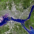
Satellite image from June 2007.
-
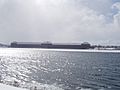
Sault Ste. Marie, Michigan Saint Marys Falls Hydropower Plant generation station.
-
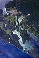
Astronaut photograph of Sault Ste. Marie.


| Climate data for Sault Ste. Marie, Michigan (1981–2010 normals, extremes 1888–present) | |||||||||||||
|---|---|---|---|---|---|---|---|---|---|---|---|---|---|
| Month | Jan | Feb | Mar | Apr | May | Jun | Jul | Aug | Sep | Oct | Nov | Dec | Year |
| Record high °F (°C) | 54 (12) |
50 (10) |
83 (28) |
85 (29) |
91 (33) |
93 (34) |
98 (37) |
98 (37) |
95 (35) |
82 (28) |
74 (23) |
62 (17) |
98 (37) |
| Mean daily maximum °F (°C) | 23.0 (−5.0) |
25.9 (−3.4) |
34.7 (1.5) |
49.4 (9.7) |
62.7 (17.1) |
71.3 (21.8) |
76.2 (24.6) |
74.7 (23.7) |
66.5 (19.2) |
53.3 (11.8) |
40.1 (4.5) |
28.6 (−1.9) |
50.5 (10.3) |
| Mean daily minimum °F (°C) | 7.6 (−13.6) |
9.4 (−12.6) |
17.9 (−7.8) |
31.1 (−0.5) |
40.9 (4.9) |
48.7 (9.3) |
54.4 (12.4) |
54.5 (12.5) |
47.7 (8.7) |
37.8 (3.2) |
28.1 (−2.2) |
15.8 (−9.0) |
32.8 (0.4) |
| Record low °F (°C) | −36 (−38) |
−37 (−38) |
−27 (−33) |
−13 (−25) |
18 (−8) |
26 (−3) |
36 (2) |
29 (−2) |
25 (−4) |
15 (−9) |
−12 (−24) |
−31 (−35) |
−37 (−38) |
| Average precipitation inches (mm) | 2.19 (56) |
1.34 (34) |
1.95 (50) |
2.39 (61) |
2.57 (65) |
2.70 (69) |
2.86 (73) |
3.17 (81) |
3.82 (97) |
3.80 (97) |
3.37 (86) |
2.79 (71) |
32.95 (840) |
| Average snowfall inches (cm) | 31.4 (80) |
18.6 (47) |
13.4 (34) |
6.7 (17) |
0.1 (0.25) |
0 (0) |
0 (0) |
0 (0) |
trace | 1.6 (4.1) |
15.1 (38) |
33.5 (85) |
120.4 (306) |
| Average precipitation days (≥ 0.01 in) | 18.4 | 13.0 | 12.3 | 10.9 | 11.2 | 11.1 | 11.2 | 10.9 | 12.9 | 15.5 | 16.7 | 18.8 | 162.9 |
| Average snowy days (≥ 0.1 in) | 19.6 | 14.2 | 10.1 | 4.6 | 0.4 | 0 | 0 | 0 | 0.1 | 2.2 | 10.0 | 18.0 | 79.2 |
| Average relative humidity (%) | 77.2 | 75.2 | 74.7 | 69.9 | 67.9 | 74.7 | 76.3 | 79.6 | 81.6 | 80.4 | 81.7 | 81.0 | 76.7 |
| Mean monthly sunshine hours | 104.9 | 142.5 | 206.4 | 227.5 | 280.3 | 281.2 | 303.6 | 248.9 | 172.9 | 122.6 | 70.4 | 77.4 | 2,238.6 |
| Percent possible sunshine | 37 | 49 | 56 | 56 | 60 | 59 | 64 | 57 | 46 | 36 | 25 | 29 | 50 |
| Source: NOAA (relative humidity and sun 1961–1990) | |||||||||||||
Population and People
| Historical population | |||
|---|---|---|---|
| Census | Pop. | %± | |
| 1860 | 596 | — | |
| 1880 | 1,947 | — | |
| 1890 | 5,760 | 195.8% | |
| 1900 | 10,538 | 83.0% | |
| 1910 | 12,615 | 19.7% | |
| 1920 | 12,096 | −4.1% | |
| 1930 | 13,755 | 13.7% | |
| 1940 | 15,847 | 15.2% | |
| 1950 | 17,912 | 13.0% | |
| 1960 | 18,722 | 4.5% | |
| 1970 | 15,136 | −19.2% | |
| 1980 | 14,448 | −4.5% | |
| 1990 | 14,689 | 1.7% | |
| 2000 | 14,324 | −2.5% | |
| 2010 | 14,144 | −1.3% | |
| 2015 (est.) | 13,827 | −2.2% | |
| source: | |||
Who Lives in Sault Ste. Marie?
In 2010, there were 14,144 people living in Sault Ste. Marie. There were 5,995 households and 3,265 families. The city had about 957 people per square mile.
- 74.8% White
- 0.7% African American
- 17.7% Native American
- 0.9% Asian
- 0.1% Pacific Islander
- 0.3% from other races
- 5.5% from two or more races
- 1.5% Hispanic or Latino (of any race)
About 28.1% of households had children under 18. About 35.0% were married couples. The average household had 2.22 people, and the average family had 2.88 people.
The average age in the city was 33.8 years. About 21.3% of residents were under 18. About 13.9% were 65 or older. For every 100 females, there were 94.2 males.
Economy and Jobs
Tourism is a big industry in Sault Ste. Marie. The Soo Locks and the nearby Kewadin Casino, Hotel and Convention Center are major attractions. The forests, lakes, and Lake Superior shoreline also draw visitors. Sault Ste. Marie is a way to explore Lake Superior's beautiful north shore through its twin city in Ontario. The Sault Ste. Marie International Bridge connects the two cities.
Education in Sault Ste. Marie

University
Sault Ste. Marie is home to Lake Superior State University (LSSU). It started in 1946 and is built on the former Fort Brady. LSSU is known for its Lakers sports teams. They play Division I Hockey and Division II in other sports. LSSU has about 2,500 students, making it Michigan's smallest public university.
High Schools
The main public high school is Sault Area High School, often called "Sault High". It has a career center attached, which is unusual for high schools in Michigan. The school's mascot is the Blue Devil. Sault High has many successful sports teams, including baseball and basketball. In total, the school offers 24 competitive sports teams for boys and girls.
Malcolm High School is an alternative school run by the district.
Middle Schools
Sault Ste. Marie has two middle schools. One is Sault Area Middle School, part of the Sault Ste. Marie School System. The other is Joseph K. Lumsden Bahweting School, a public school linked to Native American culture.
St. Mary's Catholic School serves students from kindergarten to 8th grade.
Elementary Schools
There are several elementary schools in Sault Ste. Marie and nearby areas. These include Lincoln Elementary, Washington Elementary, and Soo Township Elementary. There's also Joseph K. Lumsden Bahweting School and St. Mary's Catholic School. Some elementary schools have closed in recent years due to fewer students.
Media and News

TV Stations
Most TV stations here are rebroadcasts from Traverse City and Cadillac.
- Channel 8: WGTQ, ABC (rebroadcasts WGTU); NBC on digital subchannel 8.2 (rebroadcasts WPBN-TV)
- Channel 10: WWUP, CBS (rebroadcasts WWTV); Fox on digital subchannel 10.2 (rebroadcasts WFQX-TV)
- Channel 28: W28DY-D, 3ABN (all programming via satellite)
Radio Stations
- 1230 AM – WSOO (adult contemporary/news/sports)
- 1400 AM – WKNW (talk/sports)
- 90.1 FM – WLSO, Lake Superior State University college radio
- 91.5 FM – WJOH (Contemporary Christian) "Smile FM" (rebroadcasts WLGH from Lansing)
- 98.3 FM – WCMZ (NPR/jazz) (rebroadcasts WCMU-FM from Mount Pleasant)
- 99.5 FM – WYSS (contemporary hit radio)
- 101.3 FM – WSUE (active rock)
- 102.3 FM – WTHN (religious) (rebroadcasts WPHN-FM from Gaylord)
- 103.3 FM – W277AG (religious) (rebroadcasts WHWL-FM from Marquette)
Newspapers
The main daily newspaper in the city is the Sault Ste. Marie Evening News.
Sports and Athletics
Sault Ste. Marie offers exciting spectator sports. You can watch Lake Superior State University Athletics and the Soo Eagles hockey team.
The LSSU Lakers hockey team plays in the NCAA Division I. They play their home games at Taffy Abel Arena. This team has won three NCAA Division I championships (1988, 1992, 1994).
Other LSSU sports teams play in the NCAA Division II. The men's basketball team has won several titles. The women's basketball team also had great success from 2001 to 2005. Both basketball teams play at the Bud Cooper Gymnasium.
Famous People from Sault Ste. Marie
- Terry O'Quinn: An actor known for playing John Locke in the TV show Lost.
- John Johnston: A fur trader who built a successful business with his Ojibwe wife, Ozhaguscodaywayquay (Susan Johnston).
- Bruce Martyn: A radio and TV announcer for the Detroit Red Wings hockey team.
- Chase S. Osborn: The only Governor of Michigan from the Upper Peninsula.
- Jane Johnston Schoolcraft: Recognized as the first Native American literary writer and poet.
- Henry Rowe Schoolcraft: An ethnographer who named many places in Michigan. He was married to Jane Johnston Schoolcraft.
- Taffy Abel: A former Olympic and NHL hockey player.
- Jeff Blashill: A former head coach for the NHL's Detroit Red Wings. He grew up in Sault Ste. Marie.
Cool Places to Visit
- Pullar Stadium: Built in 1937, this ice arena is where the Soo Eagles and Sault High Blue Devils hockey teams play.
- Ramada Plaza Hotel Ojiway: This elegant hotel opened in 1927. It was a dream of Governor Chase S. Osborn, who donated the land. It has hosted famous guests like Jack Dempsey and President George H.W. Bush.
- The Soo Theatre: This theater has been a part of Sault Ste. Marie for over 80 years. It used to show movies and live performances. After closing in 1998, it was bought and restored in 2003. Now, plays and other shows are back!
- Holy Name of Mary Pro-Cathedral (Sault Ste. Marie, Michigan): This church was started by Jesuits in 1668. It's one of the oldest parishes in the United States. The current church building was built in 1881. In 1968, the church built the Tower of History as a tribute to the Catholic missionaries.
- Soo Locks: These are a series of locks that help ships travel between Lake Superior and the lower Great Lakes. They bypass rapids where the water drops 21 feet. About 10,000 ships use the locks each year. They close in winter for maintenance when ice stops shipping. The Sault Ste. Marie International Bridge crosses over the locks.
- Taffy Abel Arena: This 4,000-seat arena is home to Lake Superior State University's Division I hockey team. It's named after Clarence "Taffy" Abel, the first American-born player to become a regular in the NHL.
- Lake Superior State University: The university campus is on the former site of U.S. Army Fort Brady. Many of the old fort buildings are now used for student housing and offices. Several buildings on the 115-acre campus are listed on the National Register of Historic Places.
Sister Cities
 Ryūō, Shiga, Japan
 Sault Ste. Marie, Ontario, Canada (also a twin city)
