Schuyler County, New York facts for kids
Quick facts for kids
Schuyler County
|
|||
|---|---|---|---|

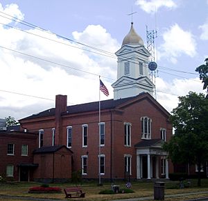
Schuyler County Courthouse
|
|||
|
|||

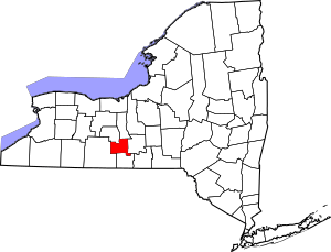
Location within the U.S. state of New York
|
|||
 New York's location within the U.S. |
|||
| Country | |||
| State | |||
| Founded | 1854 | ||
| Named for | Philip Schuyler | ||
| Seat | Watkins Glen | ||
| Largest community | Watkins Glen | ||
| Area | |||
| • Total | 342 sq mi (890 km2) | ||
| • Land | 328 sq mi (850 km2) | ||
| • Water | 14 sq mi (40 km2) 4.1% | ||
| Population
(2020)
|
|||
| • Total | 17,898 | ||
| • Density | 54.5/sq mi (21.0/km2) | ||
| Time zone | UTC−5 (Eastern) | ||
| • Summer (DST) | UTC−4 (EDT) | ||
| Congressional district | 23rd | ||
Schuyler County is a county located in the state of New York. In 2020, about 17,898 people lived here. This makes it the second smallest county in New York by population.
The main town, or county seat, is Watkins Glen. The county is named after General Philip Schuyler. He was an important general in the Continental Army during the American Revolutionary War. Schuyler County is part of the Southern Tier region of New York.
Contents
History of Schuyler County
When New York State first created counties in 1683, the area that is now Schuyler County was part of Albany County. This original Albany County was huge! It covered much of northern New York and even parts of what is now Vermont. It also stretched west all the way to the Pacific Ocean (at least on paper).
Over time, Albany County got smaller. In 1772, it was split into three parts. One new part was called Tryon County. This county included the western part of New York. It was named after William Tryon, who was the governor of New York at the time.
After the American Revolutionary War ended in 1784, many people who supported the British (called Loyalists) left Tryon County. The county's name was then changed to Montgomery County. This honored General Richard Montgomery, a hero who fought for America.
How Schuyler County Was Formed
Over many years, Montgomery County was also divided into smaller counties. This process happened many times. New counties were created from parts of older ones.
For example, Ontario County was formed in 1789. Then, Herkimer and Tioga counties were created in 1791. Later, Onondaga County was formed in 1794.
In 1796, Steuben County was created from Ontario County. Then, Chemung County was formed from Tioga County in 1798.
Finally, on April 17, 1854, parts of Steuben, Chemung, and Tompkins counties were combined. This is how Schuyler County was officially created!
Geography of Schuyler County
Schuyler County covers about 342 square miles. Most of this (328 square miles) is land, and about 14 square miles (4.1%) is water.
The county is in the western part of New York State. It is located west of Ithaca. It sits at the southern end of Seneca Lake, which is one of the famous Finger Lakes.
Part of the Finger Lakes National Forest is in the northern part of Schuyler County.
Neighboring Counties
- Seneca County - to the north
- Tompkins County - to the east
- Chemung County - to the south
- Steuben County - to the west
- Yates County - to the northwest
Protected Natural Areas
- Finger Lakes National Forest (a part of it is in Schuyler County)
People of Schuyler County
| Historical population | |||
|---|---|---|---|
| Census | Pop. | %± | |
| 1860 | 18,840 | — | |
| 1870 | 18,989 | 0.8% | |
| 1880 | 18,842 | −0.8% | |
| 1890 | 16,711 | −11.3% | |
| 1900 | 15,811 | −5.4% | |
| 1910 | 14,004 | −11.4% | |
| 1920 | 13,098 | −6.5% | |
| 1930 | 12,909 | −1.4% | |
| 1940 | 12,979 | 0.5% | |
| 1950 | 14,182 | 9.3% | |
| 1960 | 15,044 | 6.1% | |
| 1970 | 16,737 | 11.3% | |
| 1980 | 17,686 | 5.7% | |
| 1990 | 18,662 | 5.5% | |
| 2000 | 19,224 | 3.0% | |
| 2010 | 18,343 | −4.6% | |
| 2020 | 17,898 | −2.4% | |
| U.S. Decennial Census 1790-1960 1900-1990 1990-2000 2010-2020 |
|||
In 2000, there were 19,224 people living in Schuyler County. The population density was about 58 people per square mile. Most people (96.48%) identified as White. About 1.45% were African American, and 0.40% were Native American. About 1.22% of the population was Hispanic or Latino.
Most people in the county speak English (97.1%) as their first language.
2020 Census Information
The 2020 census showed the following racial makeup for Schuyler County:
| Race | Number of People | Percentage |
|---|---|---|
| White (not Hispanic) | 16,618 | 93% |
| Black or African American (not Hispanic) | 91 | 0.51% |
| Native American (not Hispanic) | 38 | 0.21% |
| Asian (not Hispanic) | 108 | 0.6% |
| Pacific Islander (not Hispanic) | 1 | 0.01% |
| Other/Mixed (not Hispanic) | 713 | 4% |
| Hispanic or Latino | 329 | 1.83% |
Transportation in Schuyler County
Schuyler County has several small, private airstrips. The closest major airport is Elmira Corning Regional Airport. Bus service is provided by Schuyler County Transit.
The county's Highway Department is in Watkins Glen. This department takes care of roads. Their jobs include:
- Building and fixing roads.
- Giving out permits for hauling and road construction.
- Clearing snow and ice from roads.
Each town and village in Schuyler County also has its own highway department.
Main Roads
 New York State Route 13
 New York State Route 14
 New York State Route 14A
 New York State Route 79
 New York State Route 224
 New York State Route 226
 New York State Route 227
 New York State Route 228
 New York State Route 230
 New York State Route 329
 New York State Route 409
 New York State Route 414
- List of county routes in Schuyler County, New York
Communities in Schuyler County
Largest Towns and Villages
These are the biggest villages in Schuyler County:
| # | Location | Population |
|---|---|---|
| 1 | †Watkins Glen | 1,859 |
| 2 | Montour Falls | 1,711 |
| 3 | Odessa | 591 |
| 4 | Burdett | 357 |
† - This is the County Seat (main town).
Towns in Schuyler County
Villages in Schuyler County
- Burdett
- Montour Falls
- Odessa
- Watkins Glen (county seat)
Small Communities (Hamlets)
- Mecklenburg
- Perry City
- Valois
See also
 In Spanish: Condado de Schuyler (Nueva York) para niños
 | Jessica Watkins |
 | Robert Henry Lawrence Jr. |
 | Mae Jemison |
 | Sian Proctor |
 | Guion Bluford |


