
Smithtown, New York facts for kids
Quick facts for kids
Smithtown, New York
|
|||
|---|---|---|---|
| Town of Smithtown | |||

Town Hall
|
|||
|
|||

Location in Suffolk County
|
|||
| Country | United States | ||
| State | New York | ||
| County | Suffolk | ||
| First settled | 1665 | ||
| Incorporated as a town | March 7, 1788 | ||
| Area | |||
| • Total | 111.45 sq mi (288.64 km2) | ||
| • Land | 53.75 sq mi (139.21 km2) | ||
| • Water | 57.70 sq mi (149.43 km2) | ||
| Elevation | 105 ft (32 m) | ||
| Population
(2020)
|
|||
| • Total | 116,296 | ||
| • Density | 2,163.6/sq mi (835.4/km2) | ||
| Time zone | UTC−5 (EST) | ||
| • Summer (DST) | UTC−4 (EDT) | ||
| ZIP codes |
11725, 11745, 11754, 11755 (part), 11768 (part), 11779 (part), 11780, 11787, 11788
|
||
| Area code(s) | 631, 934 | ||
| FIPS code | 36-68000 | ||
| Cook PVI | R+24 | ||
,_New_York_Flag.png)

Smithtown is a town located in Suffolk County, New York, on the northern coast of Long Island. It's part of the larger New York metropolitan area. In 2020, about 116,296 people lived there.
The area known as Smithtown is a specific community found within the town's borders.
Contents
Exploring Smithtown's Past
.JPG)
The land that makes up Smithtown was originally home to the Nissequogue Native Americans.
The Legend of the Smithtown Bull
A popular story, though not entirely true, tells how Smithtown got its land. It says that a man named Richard Smith saved a Native American chief's daughter. As a reward, the chief offered Smith all the land he could ride around on a bull in one day.
Smith supposedly chose the longest day of the year, the summer solstice in 1665, to ride the bull. This allowed him to cover more ground. The land he claimed is said to be very similar to Smithtown's current shape. Today, a large statue of Smith's bull, named Whisper, stands where Jericho Turnpike and St. Johnland Road meet. It reminds everyone of this famous legend.
How Smithtown Was Really Founded
Local historians say the bull story is a myth. The real story involves Lion Gardiner, an English settler, who helped rescue the Nissequogue Grand Sachem (chief) Wyandanch's daughter. She had been taken by a rival tribe.
Richard Smith, who was Gardiner's friend, was present when the princess was returned to her father. As a thank you, the Grand Sachem gave a large piece of land to Gardiner. In 1663, Gardiner sold this land to Smith. Two years later, in 1665, the colonial Governor Richard Nicolls officially approved Smith's claim to the land. This is why 1665 is considered the year Smithtown was founded.
Smithtown was first called "Smithfield." The border between Smithtown and the town of Huntington follows a road called Bread and Cheese Hollow Road. The name comes from a legend that Richard Smith stopped there for lunch during his bull ride.
Celebrating 350 Years
In 2015, Smithtown celebrated its 350th anniversary. A new statue of founder Richard Smith was revealed. It stands in front of an office building at the intersection of Main Street and Route 111.
Smithtown's Location and Size
Smithtown is bordered by the Long Island Sound to the north. To the south is Islip, to the east is Brookhaven, and to the west is Huntington.
The town covers about 111.5 square miles (288.64 square kilometers). About 53.8 square miles (139.21 square kilometers) is land, and 57.7 square miles (149.43 square kilometers) is water. This means a large part of Smithtown's area is water!
People of Smithtown
| Historical population | |||
|---|---|---|---|
| Census | Pop. | %± | |
| 1790 | 1,022 | — | |
| 1800 | 1,413 | 38.3% | |
| 1810 | 1,592 | 12.7% | |
| 1820 | 1,874 | 17.7% | |
| 1830 | 1,686 | −10.0% | |
| 1840 | 1,932 | 14.6% | |
| 1850 | 1,972 | 2.1% | |
| 1860 | 2,130 | 8.0% | |
| 1870 | 2,136 | 0.3% | |
| 1880 | 2,249 | 5.3% | |
| 1890 | 3,357 | 49.3% | |
| 1900 | 5,863 | 74.6% | |
| 1910 | 7,073 | 20.6% | |
| 1920 | 9,114 | 28.9% | |
| 1930 | 11,855 | 30.1% | |
| 1940 | 13,970 | 17.8% | |
| 1950 | 20,993 | 50.3% | |
| 1960 | 50,347 | 139.8% | |
| 1970 | 114,657 | 127.7% | |
| 1980 | 116,663 | 1.7% | |
| 1990 | 113,406 | −2.8% | |
| 2000 | 115,715 | 2.0% | |
| 2010 | 117,801 | 1.8% | |
| 2020 | 116,296 | −1.3% | |
| U.S. Decennial Census | |||
In 2000, there were about 115,715 people living in Smithtown. Most families living together were married couples. The average household had almost three people.
The population was spread out by age. About 26% of the people were under 18 years old. The median age was 38 years old. This means half the people were younger than 38 and half were older.
Many people in Smithtown have Italian, Irish, German, Polish, English, or Russian backgrounds.
Communities and Places in Smithtown
Smithtown includes several different communities. Some are "villages" with their own local governments, and others are "hamlets" which are unincorporated areas.
Villages (with their own governments)
Hamlets (unincorporated communities)
- Commack (partially shared with Town of Huntington)
- Fort Salonga (partially shared with Town of Huntington)
- Hauppauge (partially shared with Town of Islip)
- Kings Park
- Lake Ronkonkoma (partially shared with Town of Brookhaven and Town of Islip)
- Nesconset
- Smithtown
- St. James
Other Areas to Know
- North Smithtown
- San Remo
- Smithtown Pines
State Parks to Explore
Smithtown is home to several beautiful state parks:
- Caleb Smith State Park Preserve
- Sunken Meadow State Park
- Nissequogue River State Park
- Blydenburgh Park Historic District
Media and Culture in Smithtown

Smithtown has its own public television station, SGTV, where you can watch town board meetings. The local newspaper, The Times of Smithtown, shares community news.
The Smithtown Performing Arts Center is a theater located at 2 East Main Street. This historic building was built in 1933 and used to be a movie theater. In 2002, it was updated for live performances. Today, a non-profit group runs the center, offering musicals, plays, music, comedy, and educational programs.
Emergency Services in Smithtown
Local fire protection and Emergency Medical Services (EMS) are provided by volunteer fire departments and ambulance corps. These groups are made up of people who volunteer their time to help the community.
The Suffolk County Police Department's 4th Precinct handles all 911 emergency calls in Smithtown. The Smithtown Department of Public Safety also helps keep the town safe. Their Park Rangers are peace officers who work on town property. They also have Harbor Masters and Fire Marshals.
For medical emergencies, there's St. Catherine of Siena Medical Center in Smithtown. Stony Brook University Hospital is also nearby.
Getting Around Smithtown
Train Stations
The Long Island Rail Road's Port Jefferson Branch has stations in Smithtown. You can catch a train at:
- Kings Park
- Smithtown
- Saint James
Bus Services
Suffolk County Transit bus routes serve the entire town of Smithtown, making it easy to get around without a car.
Main Roads in Smithtown

Several important roads run through Smithtown:
 I-495 is the Long Island Expressway. It passes through the southwest part of town.
 Northern State Parkway is a major highway that goes from west to east.
 Sagtikos State Parkway runs from south to north, connecting to the Northern State Parkway.
 Sunken Meadow State Parkway continues from the Sagtikos Parkway and leads to Sunken Meadow State Park.
 NY 25A is a northern road that goes through Fort Salonga, Kings Park, and St. James.
 NY 25 is also known as Jericho Turnpike and Middle Country Road. It runs through the town from west to east.
 CR 16 includes Terry Road and Smithtown Boulevard.
 CR 67 is part of the historic Long Island Motor Parkway.
 NY 111
 NY 347
 NY 454
Education in Smithtown
The Smithtown Central School District serves many students in the area. It has seven elementary schools, three middle schools, and two high schools.
Other parts of Smithtown are served by different school districts, including Kings Park, Commack, Hauppauge, and Sachem.
Elementary Schools
- Accompsett Elementary School
- Dogwood Elementary School
- Mills Pond Elementary School
- Mt. Pleasant Elementary School
- Smithtown Elementary School
- St. James Elementary School
- Tackan Elementary School
Middle Schools
- Accompsett Middle School
- Great Hollow Middle School
- Nesaquake Middle School
Smithtown High Schools
- Eastern Campus (located in St. James)
- Western Campus (located south of Kings Park Hamlet)

Private Schools
- Smithtown Christian School (for students from pre-school through twelfth grade)
Famous People from Smithtown
Many notable people have lived in or are from Smithtown, including:
- Mose Allison, a jazz and blues musician
- Craig Biggio, a former Major League baseball player
- Bob Costas, a famous sportscaster
- Mick Foley, a former professional wrestler and author
- Melissa Joan Hart, an American actress
- Lori Loughlin, an actress
- Michael P. Murphy, a Medal of Honor recipient
- Soledad O'Brien, a TV news anchor
- John Petrucci, guitarist for the band Dream Theater
- Jodi Picoult, a novelist
- William Weld, a former Governor of Massachusetts
Images for kids
-
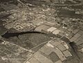
Smithtown in 1931
.jpg)
See also
 In Spanish: Smithtown (Nueva York) para niños
